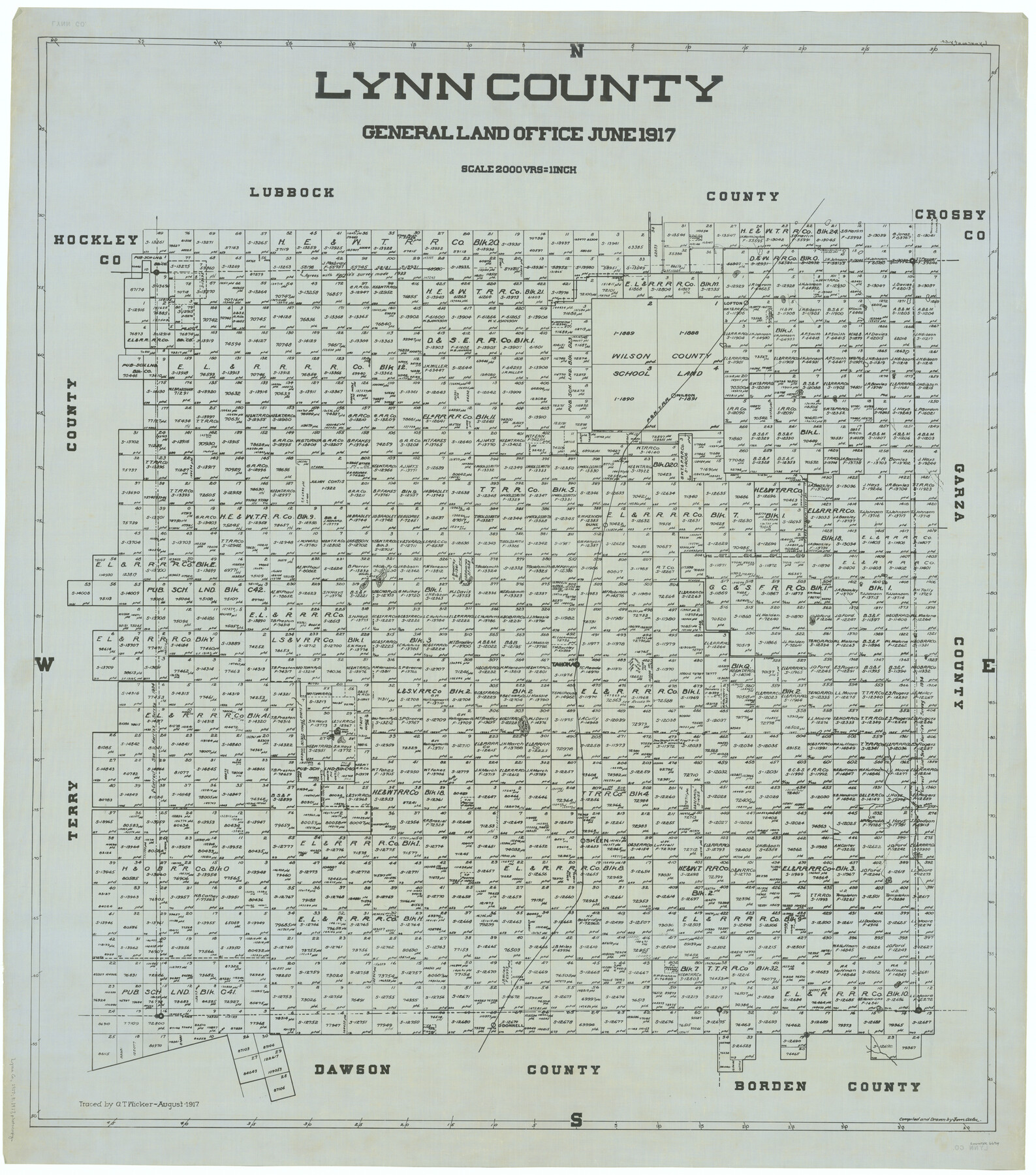
Lynn County
-
Map/Doc
66914
-
Collection
General Map Collection
-
Object Dates
1917 (Creation Date)
-
People and Organizations
Texas General Land Office (Publisher)
Tom G. Atlee (Draftsman)
Tom G. Atlee (Compiler)
-
Counties
Lynn
-
Subjects
County
-
Height x Width
44.6 x 39.4 inches
113.3 x 100.1 cm
-
Comments
Traced in August 1917 by G. T. Wicker.
Part of: General Map Collection
University Lands Block 35 Crane & Ector Counties

Print $20.00
- Digital $50.00
University Lands Block 35 Crane & Ector Counties
1935
Size 40.2 x 46.7 inches
Map/Doc 2442
Right of Way and Track Map International & Gt. Northern Ry. operated by the International & Gt. Northern Ry. Co., Gulf Division, Columbia Branch

Print $40.00
- Digital $50.00
Right of Way and Track Map International & Gt. Northern Ry. operated by the International & Gt. Northern Ry. Co., Gulf Division, Columbia Branch
1917
Size 25.1 x 57.0 inches
Map/Doc 64600
Burleson County Working Sketch 42

Print $20.00
- Digital $50.00
Burleson County Working Sketch 42
1953
Size 41.6 x 33.6 inches
Map/Doc 67761
[Surveying Test and Answer Key]
![76001, [Surveying Test and Answer Key], General Map Collection](https://historictexasmaps.com/wmedia_w700/maps/76001.tif.jpg)
Print $20.00
- Digital $50.00
[Surveying Test and Answer Key]
Size 17.5 x 19.9 inches
Map/Doc 76001
Kerr County Rolled Sketch 14

Print $20.00
- Digital $50.00
Kerr County Rolled Sketch 14
1951
Size 38.3 x 30.6 inches
Map/Doc 9345
Edwards County Sketch File 2 and 3

Print $8.00
- Digital $50.00
Edwards County Sketch File 2 and 3
1874
Size 9.3 x 4.1 inches
Map/Doc 21676
Sterling County Rolled Sketch 22

Print $20.00
- Digital $50.00
Sterling County Rolled Sketch 22
Size 33.6 x 30.8 inches
Map/Doc 9953
Flight Mission No. BRE-2P, Frame 77, Nueces County

Print $20.00
- Digital $50.00
Flight Mission No. BRE-2P, Frame 77, Nueces County
1956
Size 18.4 x 22.2 inches
Map/Doc 86772
Presidio County Sketch File 66

Print $6.00
- Digital $50.00
Presidio County Sketch File 66
1940
Size 11.4 x 8.7 inches
Map/Doc 34656
Young County Working Sketch 10

Print $20.00
- Digital $50.00
Young County Working Sketch 10
1921
Size 24.4 x 34.4 inches
Map/Doc 62033
Rand, McNally and Co.'s Texas and Indian Territory

Print $20.00
- Digital $50.00
Rand, McNally and Co.'s Texas and Indian Territory
1883
Size 24.3 x 18.6 inches
Map/Doc 4331
Flight Mission No. BRA-3M, Frame 122, Jefferson County

Print $20.00
- Digital $50.00
Flight Mission No. BRA-3M, Frame 122, Jefferson County
1953
Size 18.7 x 22.3 inches
Map/Doc 85396
You may also like
Bowie County Sketch File 7

Print $40.00
- Digital $50.00
Bowie County Sketch File 7
1927
Size 18.0 x 35.5 inches
Map/Doc 10943
Motley County Sketch File 6 (S)

Print $22.00
- Digital $50.00
Motley County Sketch File 6 (S)
Size 12.9 x 13.8 inches
Map/Doc 32145
Flight Mission No. BRA-8M, Frame 83, Jefferson County

Print $20.00
- Digital $50.00
Flight Mission No. BRA-8M, Frame 83, Jefferson County
1953
Size 15.8 x 15.7 inches
Map/Doc 85603
McCulloch County Rolled Sketch 7

Print $20.00
- Digital $50.00
McCulloch County Rolled Sketch 7
1982
Size 20.7 x 30.5 inches
Map/Doc 6718
Canada, United States of America, Estados Unidos Mexicanos

Print $20.00
- Digital $50.00
Canada, United States of America, Estados Unidos Mexicanos
Size 41.9 x 36.1 inches
Map/Doc 96512
Oldham County Working Sketch 4

Print $20.00
- Digital $50.00
Oldham County Working Sketch 4
1948
Size 28.8 x 26.2 inches
Map/Doc 71326
King County Working Sketch 16

Print $40.00
- Digital $50.00
King County Working Sketch 16
1979
Size 41.4 x 59.4 inches
Map/Doc 70180
Pecos County Working Sketch 28

Print $20.00
- Digital $50.00
Pecos County Working Sketch 28
1935
Size 27.9 x 29.2 inches
Map/Doc 71500

Kendall County Working Sketch 7

Print $20.00
- Digital $50.00
Kendall County Working Sketch 7
1950
Size 30.8 x 32.4 inches
Map/Doc 66679
Knox County Rolled Sketch 20

Print $20.00
- Digital $50.00
Knox County Rolled Sketch 20
Size 31.5 x 23.3 inches
Map/Doc 6560
Foard County Working Sketch 11

Print $20.00
- Digital $50.00
Foard County Working Sketch 11
1977
Size 26.7 x 35.6 inches
Map/Doc 69202