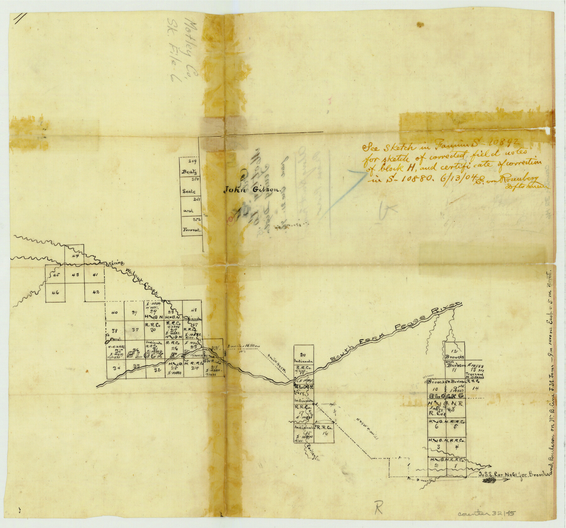
Motley County Sketch File 6 (S)
[Sketch of surveys on South Fork of Pease River]
-
Map/Doc
32145
-
Collection
General Map Collection
-
Object Dates
12/21/1896 (File Date)
-
Counties
Motley Dickens
-
Subjects
Surveying Sketch File
-
Height x Width
12.9 x 13.8 inches
32.8 x 35.1 cm
-
Medium
paper, manuscript
-
Features
Walnut Creek
South Fork of Pease River
Turkey Creek
Part of: General Map Collection
Hamilton County Rolled Sketch 11

Print $20.00
- Digital $50.00
Hamilton County Rolled Sketch 11
Size 20.1 x 14.1 inches
Map/Doc 6060
Colorado River, El Campo Sheet

Print $6.00
- Digital $50.00
Colorado River, El Campo Sheet
1939
Size 27.4 x 35.2 inches
Map/Doc 65318
Cameron County Rolled Sketch 13

Print $40.00
- Digital $50.00
Cameron County Rolled Sketch 13
1952
Size 37.7 x 62.7 inches
Map/Doc 61787
Newton County Rolled Sketch 25

Print $20.00
- Digital $50.00
Newton County Rolled Sketch 25
1893
Size 22.4 x 18.7 inches
Map/Doc 6853
Flight Mission No. DAH-9M, Frame 205, Orange County

Print $20.00
- Digital $50.00
Flight Mission No. DAH-9M, Frame 205, Orange County
1953
Size 18.7 x 22.6 inches
Map/Doc 86873
Duval County Sketch File 31

Print $20.00
- Digital $50.00
Duval County Sketch File 31
1932
Size 29.3 x 17.7 inches
Map/Doc 11389
Montgomery County Boundary File 1

Print $4.00
- Digital $50.00
Montgomery County Boundary File 1
Size 5.8 x 5.5 inches
Map/Doc 57446

Burleson County Working Sketch 31

Print $40.00
- Digital $50.00
Burleson County Working Sketch 31
1981
Size 70.6 x 37.8 inches
Map/Doc 67750
Hardin County Working Sketch 18

Print $20.00
- Digital $50.00
Hardin County Working Sketch 18
1944
Size 18.7 x 22.0 inches
Map/Doc 63416
Karnes County Working Sketch Graphic Index

Print $20.00
- Digital $50.00
Karnes County Working Sketch Graphic Index
1921
Size 45.0 x 40.3 inches
Map/Doc 76600
Flight Mission No. CUG-3P, Frame 79, Kleberg County

Print $20.00
- Digital $50.00
Flight Mission No. CUG-3P, Frame 79, Kleberg County
1956
Size 18.4 x 22.2 inches
Map/Doc 86254
You may also like
[Surveys in Austin's Colony along Saline Creek]
![180, [Surveys in Austin's Colony along Saline Creek], General Map Collection](https://historictexasmaps.com/wmedia_w700/maps/180.tif.jpg)
Print $20.00
- Digital $50.00
[Surveys in Austin's Colony along Saline Creek]
Size 20.8 x 20.7 inches
Map/Doc 180
San Jacinto County Sketch File 17

Print $40.00
San Jacinto County Sketch File 17
1934
Size 60.1 x 26.3 inches
Map/Doc 10598
Schleicher County Sketch File 3

Print $20.00
- Digital $50.00
Schleicher County Sketch File 3
Size 28.1 x 19.9 inches
Map/Doc 12295
Flight Mission No. DQO-12K, Frame 40, Galveston County

Print $20.00
- Digital $50.00
Flight Mission No. DQO-12K, Frame 40, Galveston County
1952
Size 18.6 x 22.3 inches
Map/Doc 85230

Flight Mission No. BQR-9K, Frame 11, Brazoria County

Print $20.00
- Digital $50.00
Flight Mission No. BQR-9K, Frame 11, Brazoria County
1952
Size 18.7 x 22.4 inches
Map/Doc 84040
Flight Mission No. CGI-1N, Frame 185, Cameron County

Print $20.00
- Digital $50.00
Flight Mission No. CGI-1N, Frame 185, Cameron County
1955
Size 18.6 x 22.2 inches
Map/Doc 84520
Guadalupe County Working Sketch 2

Print $20.00
- Digital $50.00
Guadalupe County Working Sketch 2
1925
Size 37.2 x 19.2 inches
Map/Doc 63311
Dawson County Working Sketch 17

Print $20.00
- Digital $50.00
Dawson County Working Sketch 17
1961
Size 33.3 x 29.9 inches
Map/Doc 68561
Flight Mission No. BRA-7M, Frame 142, Jefferson County

Print $20.00
- Digital $50.00
Flight Mission No. BRA-7M, Frame 142, Jefferson County
1953
Size 18.6 x 22.5 inches
Map/Doc 85536
Brazoria County Working Sketch 32

Print $20.00
- Digital $50.00
Brazoria County Working Sketch 32
1979
Size 15.8 x 36.9 inches
Map/Doc 67517
Concho County

Print $20.00
- Digital $50.00
Concho County
1897
Size 45.9 x 38.0 inches
Map/Doc 66785