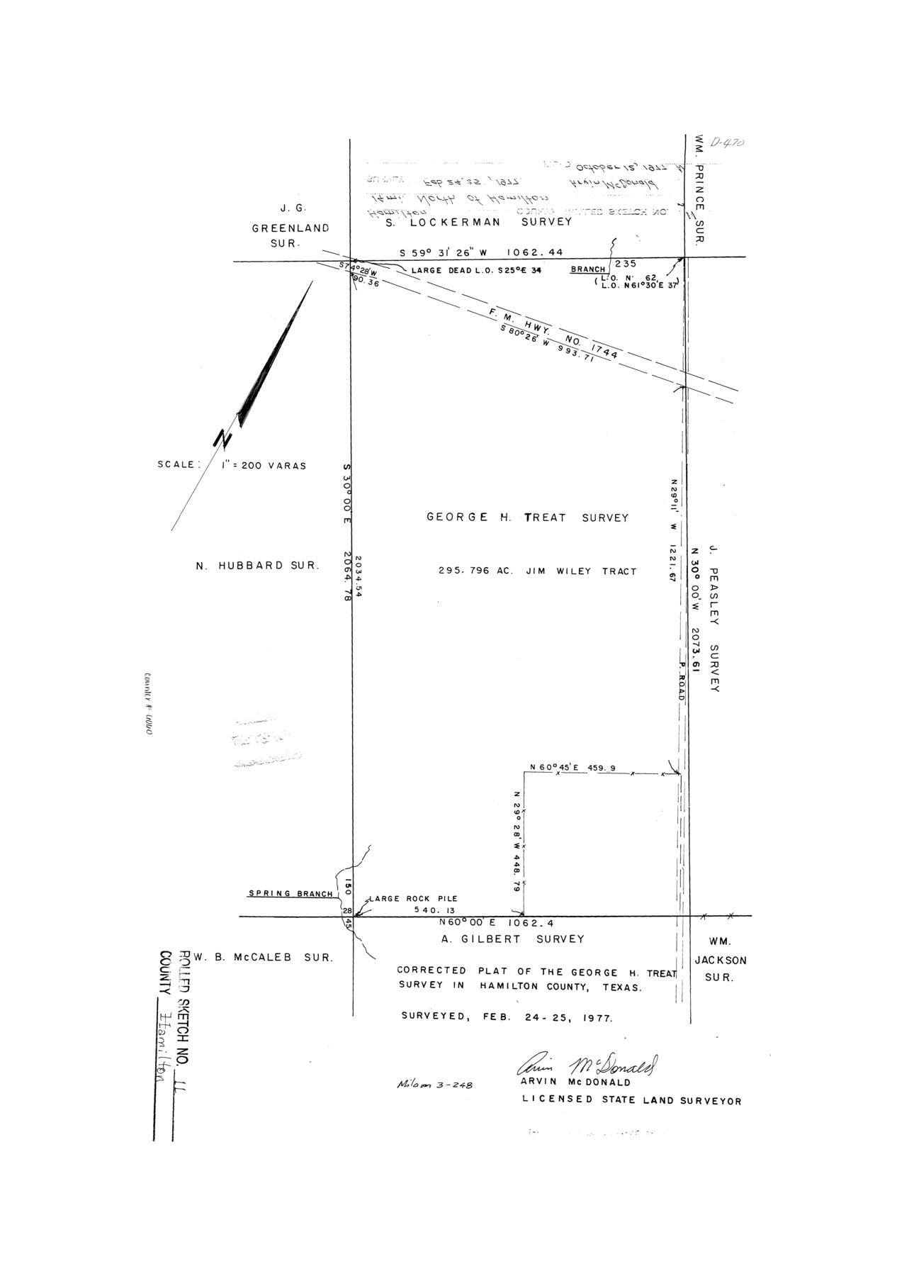
Hamilton County Rolled Sketch 11
Corrected plat of the George H. Treat survey in Hamilton County, Texas
-
Map/Doc
6060
-
Collection
General Map Collection
-
Object Dates
1977/2/25 (Survey Date)
1977/10/12 (File Date)
-
People and Organizations
Arvin McDonald (Surveyor/Engineer)
-
Counties
Hamilton
-
Subjects
Surveying Rolled Sketch
-
Height x Width
20.1 x 14.1 inches
51.1 x 35.8 cm
-
Scale
1" = 200 varas
Part of: General Map Collection
[Overlay for Fractional Township No. 7 South Range No. 17 East of the Indian Meridian, Indian Territory]
![75230, [Overlay for Fractional Township No. 7 South Range No. 17 East of the Indian Meridian, Indian Territory], General Map Collection](https://historictexasmaps.com/wmedia_w700/maps/75230.tif.jpg)
Print $3.00
- Digital $50.00
[Overlay for Fractional Township No. 7 South Range No. 17 East of the Indian Meridian, Indian Territory]
Size 11.2 x 11.7 inches
Map/Doc 75230
Old Miscellaneous File 3

Print $4.00
- Digital $50.00
Old Miscellaneous File 3
1839
Size 8.8 x 8.2 inches
Map/Doc 75414
Newton County Working Sketch 28

Print $40.00
- Digital $50.00
Newton County Working Sketch 28
1954
Size 34.7 x 55.0 inches
Map/Doc 71274
Harrison County Working Sketch 11

Print $20.00
- Digital $50.00
Harrison County Working Sketch 11
1961
Size 27.8 x 28.0 inches
Map/Doc 66031
Calhoun County Rolled Sketch 27

Print $127.00
- Digital $50.00
Calhoun County Rolled Sketch 27
1976
Size 10.1 x 16.0 inches
Map/Doc 43621
Upton County Rolled Sketch 59A

Print $20.00
- Digital $50.00
Upton County Rolled Sketch 59A
Size 35.7 x 45.9 inches
Map/Doc 76423
Freestone County Working Sketch 19

Print $20.00
- Digital $50.00
Freestone County Working Sketch 19
1980
Size 39.3 x 44.4 inches
Map/Doc 69261
Flight Mission No. CUG-2P, Frame 28, Kleberg County

Print $20.00
- Digital $50.00
Flight Mission No. CUG-2P, Frame 28, Kleberg County
1956
Size 18.5 x 22.2 inches
Map/Doc 86193
Polk County Working Sketch 20

Print $40.00
- Digital $50.00
Polk County Working Sketch 20
1952
Size 42.2 x 51.7 inches
Map/Doc 71635
Map of Chicago, Rock Island & Texas Railway

Print $20.00
- Digital $50.00
Map of Chicago, Rock Island & Texas Railway
1892
Size 22.4 x 44.0 inches
Map/Doc 64443
Harris County Historic Topographic 7

Print $20.00
- Digital $50.00
Harris County Historic Topographic 7
1916
Size 20.4 x 23.4 inches
Map/Doc 65817
Williamson County Working Sketch 5

Print $20.00
- Digital $50.00
Williamson County Working Sketch 5
1919
Size 23.4 x 18.3 inches
Map/Doc 72565
You may also like
Bowie County Sketch File 9

Print $10.00
- Digital $50.00
Bowie County Sketch File 9
Size 8.1 x 3.9 inches
Map/Doc 14907
Rains County Rolled Sketch 1

Print $40.00
- Digital $50.00
Rains County Rolled Sketch 1
1958
Size 42.0 x 65.2 inches
Map/Doc 9806
[Leagues along West line of County]
![90547, [Leagues along West line of County], Twichell Survey Records](https://historictexasmaps.com/wmedia_w700/maps/90547-1.tif.jpg)
Print $2.00
- Digital $50.00
[Leagues along West line of County]
Size 5.7 x 11.6 inches
Map/Doc 90547
The Peters Colony. August 30, 1841

Print $20.00
The Peters Colony. August 30, 1841
2020
Size 21.7 x 21.7 inches
Map/Doc 96362
Uvalde County Sketch File 26-1

Print $6.00
- Digital $50.00
Uvalde County Sketch File 26-1
1930
Size 11.5 x 8.9 inches
Map/Doc 39013
Hale County Boundary File 4

Print $40.00
- Digital $50.00
Hale County Boundary File 4
Size 8.8 x 4.2 inches
Map/Doc 54048
Harris County Working Sketch 74

Print $20.00
- Digital $50.00
Harris County Working Sketch 74
1959
Size 25.7 x 30.0 inches
Map/Doc 65966
Galveston to Rio Grande

Print $20.00
- Digital $50.00
Galveston to Rio Grande
1973
Size 44.2 x 36.8 inches
Map/Doc 69956
Duval County Sketch File 64

Print $6.00
- Digital $50.00
Duval County Sketch File 64
1942
Size 14.2 x 9.0 inches
Map/Doc 21438
Stephens County Working Sketch 38

Print $20.00
- Digital $50.00
Stephens County Working Sketch 38
1988
Size 24.3 x 32.7 inches
Map/Doc 63981
Sutton County Sketch File 18

Print $94.00
- Digital $50.00
Sutton County Sketch File 18
1893
Size 12.9 x 8.3 inches
Map/Doc 37410
Brown County State Real Property Sketch 1

Print $80.00
- Digital $50.00
Brown County State Real Property Sketch 1
2018
Size 48.0 x 36.0 inches
Map/Doc 95204