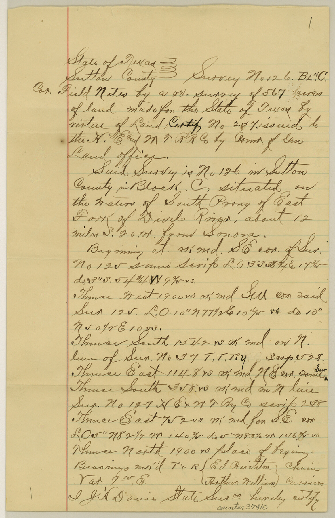
Sutton County Sketch File 18
[Sketch Showing Surveys in Sutton County, Texas]
-
Map/Doc
37410
-
Collection
General Map Collection
-
Object Dates
1912/5/24 (File Date)
1903/4/25 (Survey Date)
1893 (Creation Date)
1893 (Survey Date)
-
People and Organizations
J.H. Davis (Surveyor/Engineer)
Ed Creichton (Chainman/Field Personnel)
Arthur Williams (Chainman/Field Personnel)
-
Counties
Sutton
-
Subjects
Surveying Sketch File
-
Height x Width
12.9 x 8.3 inches
32.8 x 21.1 cm
-
Medium
paper, manuscript
-
Features
South Prong of East Fork of Devil's River
South Prong of East Fork of Devil's River
North Prong of East Fork of Devil's River
East Fork of Devil's River
Part of: General Map Collection
Kimble County

Print $40.00
- Digital $50.00
Kimble County
1930
Size 44.8 x 50.3 inches
Map/Doc 95557
Gillespie County Sketch File 12

Print $4.00
- Digital $50.00
Gillespie County Sketch File 12
1877
Size 9.6 x 6.3 inches
Map/Doc 24151
Brown County Working Sketch 14

Print $20.00
- Digital $50.00
Brown County Working Sketch 14
1989
Size 20.1 x 21.3 inches
Map/Doc 67779
Presidio County Working Sketch 146

Print $20.00
- Digital $50.00
Presidio County Working Sketch 146
1989
Size 20.7 x 20.6 inches
Map/Doc 71824
Childress County Rolled Sketch 12

Print $20.00
- Digital $50.00
Childress County Rolled Sketch 12
1940
Size 44.2 x 11.3 inches
Map/Doc 8603
Austin County Sketch File 14

Print $40.00
- Digital $50.00
Austin County Sketch File 14
Size 18.8 x 8.8 inches
Map/Doc 13880
Gray County Boundary File 1

Print $10.00
- Digital $50.00
Gray County Boundary File 1
Size 11.4 x 8.8 inches
Map/Doc 53845
Karnes County Sketch File 2

Print $6.00
- Digital $50.00
Karnes County Sketch File 2
1851
Size 12.5 x 8.1 inches
Map/Doc 28547
Rockwall County Sketch File 1

Print $22.00
Rockwall County Sketch File 1
Size 14.5 x 16.1 inches
Map/Doc 35413
Jefferson County Rolled Sketch 61G

Print $20.00
- Digital $50.00
Jefferson County Rolled Sketch 61G
1928
Size 27.2 x 40.3 inches
Map/Doc 6416
Current Miscellaneous File 63

Print $6.00
- Digital $50.00
Current Miscellaneous File 63
1957
Size 14.1 x 8.8 inches
Map/Doc 74100
Flight Mission No. BRA-16M, Frame 93, Jefferson County

Print $20.00
- Digital $50.00
Flight Mission No. BRA-16M, Frame 93, Jefferson County
1953
Size 18.5 x 22.4 inches
Map/Doc 85705
You may also like
Flight Mission No. DQN-3K, Frame 72, Calhoun County

Print $20.00
- Digital $50.00
Flight Mission No. DQN-3K, Frame 72, Calhoun County
1953
Size 16.2 x 16.1 inches
Map/Doc 84363
Lyons Subdivision North Part Block 79

Print $20.00
- Digital $50.00
Lyons Subdivision North Part Block 79
Size 19.6 x 24.5 inches
Map/Doc 92795
Pecos County Working Sketch 121

Print $20.00
- Digital $50.00
Pecos County Working Sketch 121
1973
Size 44.3 x 37.7 inches
Map/Doc 71594
[Rosebud Station Map - Tracks and Structures - Lands, San Antonio and Aransas Pass Railway Co.]
![62566, [Rosebud Station Map - Tracks and Structures - Lands, San Antonio and Aransas Pass Railway Co.], General Map Collection](https://historictexasmaps.com/wmedia_w700/maps/62566.tif.jpg)
Print $4.00
- Digital $50.00
[Rosebud Station Map - Tracks and Structures - Lands, San Antonio and Aransas Pass Railway Co.]
1919
Size 11.7 x 18.6 inches
Map/Doc 62566
Acreage in Texas Counties

Print $20.00
- Digital $50.00
Acreage in Texas Counties
1966
Size 47.1 x 25.8 inches
Map/Doc 73594
El Paso County Sketch File 26

Print $20.00
- Digital $50.00
El Paso County Sketch File 26
Size 24.8 x 21.9 inches
Map/Doc 11457
Map of Texas and the Countries Adjacent

Map of Texas and the Countries Adjacent
1844
Size 19.0 x 29.6 inches
Map/Doc 94561
Frio County Boundary File 31b

Print $72.00
- Digital $50.00
Frio County Boundary File 31b
Size 9.4 x 4.5 inches
Map/Doc 53617
Dickens County Rolled Sketch P1

Print $20.00
- Digital $50.00
Dickens County Rolled Sketch P1
1915
Size 40.5 x 36.2 inches
Map/Doc 8783
Presidio County Sketch File 110

Print $12.00
- Digital $50.00
Presidio County Sketch File 110
1886
Size 12.3 x 8.5 inches
Map/Doc 34818
[St. L. S-W. Ry. of Texas Map of Lufkin Branch in Angelina County, Texas]
![64561, [St. L. S-W. Ry. of Texas Map of Lufkin Branch in Angelina County, Texas], General Map Collection](https://historictexasmaps.com/wmedia_w700/maps/64561-1.tif.jpg)
Print $40.00
- Digital $50.00
[St. L. S-W. Ry. of Texas Map of Lufkin Branch in Angelina County, Texas]
1913
Size 25.4 x 121.3 inches
Map/Doc 64561
Fort Bend County Sketch File 28

Print $40.00
- Digital $50.00
Fort Bend County Sketch File 28
Size 13.7 x 8.6 inches
Map/Doc 22979