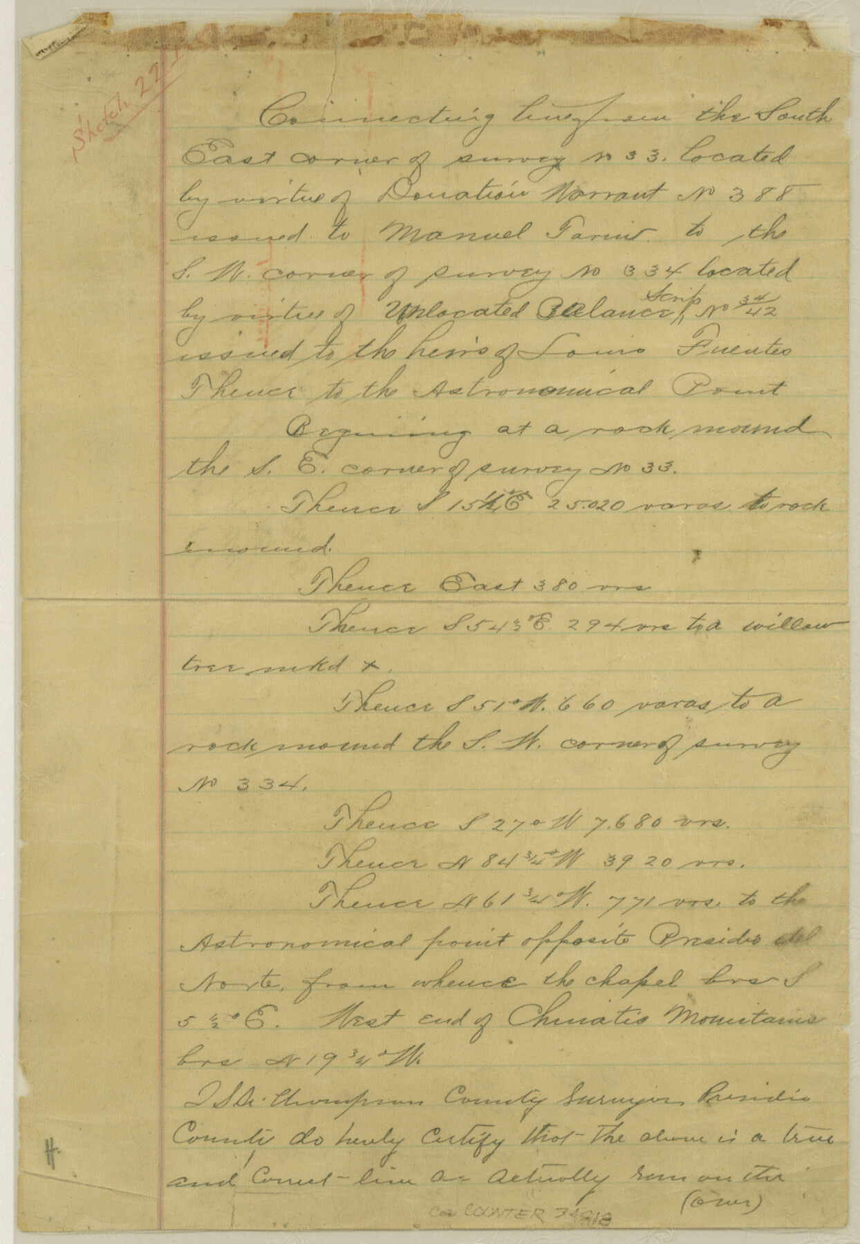
Presidio County Sketch File 110
[Reports of three connecting lines in south half of Presidio County]
- 
                          Map/Doc34818
- 
                            CollectionGeneral Map Collection
- 
                            Object Dates7/1886 (Creation Date)9/13/1886 (File Date)7/28/1853 (Creation Date)
- 
                            People and OrganizationsS.A. Thompson (Surveyor/Engineer)
- 
                            CountiesPresidio
- 
                            SubjectsSurveying Sketch File
- 
                            Height x Width12.3 x 8.5 inches31.2 x 21.6 cm
- 
                            Mediumpaper, manuscript
- 
                            FeaturesPresidio Del NorteIndia Creek
Part of: General Map Collection
            Fort Bend County Sketch File 30


                                            Print $18.00                    
                                             -                         Digital $50.00                                    
                Fort Bend County Sketch File 30
1920
Size 12.1 x 6.5 inches
                                Map/Doc 22988
            
            Motley County Sketch File 20 (N)


                                            Print $6.00                    
                                             -                         Digital $50.00                                    
                Motley County Sketch File 20 (N)
1943
Size 11.3 x 8.8 inches
                                Map/Doc 32066
            
            Crane County Working Sketch 17


                                            Print $20.00                    
                                             -                         Digital $50.00                                    
                Crane County Working Sketch 17
1957
Size 10.7 x 37.0 inches
                                Map/Doc 63911
            
            La Salle County Working Sketch 33


                                            Print $20.00                    
                                             -                         Digital $50.00                                    
                La Salle County Working Sketch 33
1956
Size 33.0 x 38.3 inches
                                Map/Doc 70334
            
            United States - Gulf Coast - From Latitude 26° 33' to the Rio Grande Texas


                                            Print $20.00                    
                                             -                         Digital $50.00                                    
                United States - Gulf Coast - From Latitude 26° 33' to the Rio Grande Texas
1913
Size 18.4 x 27.9 inches
                                Map/Doc 72842
            
            Duval County Sketch File 6a


                                            Print $20.00                    
                                             -                         Digital $50.00                                    
                Duval County Sketch File 6a
1875
Size 10.9 x 22.9 inches
                                Map/Doc 11382
            
            Hood County Working Sketch 6


                                            Print $40.00                    
                                             -                         Digital $50.00                                    
                Hood County Working Sketch 6
1969
Size 39.4 x 48.0 inches
                                Map/Doc 66200
            
            Dimmit County Sketch File 41


                                            Print $4.00                    
                                             -                         Digital $50.00                                    
                Dimmit County Sketch File 41
1901
Size 14.6 x 9.1 inches
                                Map/Doc 21169
            
            Culberson County Working Sketch 33


                                            Print $20.00                    
                                             -                         Digital $50.00                                    
                Culberson County Working Sketch 33
1960
Size 26.9 x 34.1 inches
                                Map/Doc 68486
            
            [Sketch for Mineral Application 26649-26650 - Sabine River, Harry A. Wolan]
            
                                    ![65565, [Sketch for Mineral Application 26649-26650 - Sabine River, Harry A. Wolan], General Map Collection](https://historictexasmaps.com/wmedia_w700/maps/65565.tif.jpg) 


    ![65565, [Sketch for Mineral Application 26649-26650 - Sabine River, Harry A. Wolan], General Map Collection](https://historictexasmaps.com/wmedia_w700/maps/65565.tif.jpg) 
                                
            
                                            Print $40.00                    
                                             -                         Digital $50.00                                    
                [Sketch for Mineral Application 26649-26650 - Sabine River, Harry A. Wolan]
Size 36.8 x 71.9 inches
                                Map/Doc 65565
            
            Collingsworth County Sketch File 5


                                            Print $20.00                    
                                             -                         Digital $50.00                                    
                Collingsworth County Sketch File 5
1891
Size 32.0 x 24.3 inches
                                Map/Doc 11132
            
            Flight Mission No. CRC-4R, Frame 159, Chambers County


                                            Print $20.00                    
                                             -                         Digital $50.00                                    
                Flight Mission No. CRC-4R, Frame 159, Chambers County
1956
Size 18.6 x 22.2 inches
                                Map/Doc 84918
            You may also like
            The Judicial District/County of Ward. Created, January 19, 1841


                                            Print $20.00                    
                                    
                The Judicial District/County of Ward. Created, January 19, 1841
2020
Size 18.7 x 21.7 inches
                                Map/Doc 96354
            
            Anderson County Boundary File 2


                                            Print $8.00                    
                                             -                         Digital $50.00                                    
                Anderson County Boundary File 2
Size 14.3 x 8.7 inches
                                Map/Doc 49730
            
            Dickens County Working Sketch 15


                                            Print $20.00                    
                                             -                         Digital $50.00                                    
                Dickens County Working Sketch 15
2011
Size 28.8 x 28.6 inches
                                Map/Doc 90067
            
            Geological map of Texas showing approximate locations and drilling wells. Also names of companies drilling


                                            Print $20.00                    
                                             -                         Digital $50.00                                    
                Geological map of Texas showing approximate locations and drilling wells. Also names of companies drilling
1920
Size 26.9 x 26.6 inches
                                Map/Doc 93937
            
            [Worksheets related to the Wilson Strickland survey and vicinity]
            
                                    ![91381, [Worksheets related to the Wilson Strickland survey and vicinity], Twichell Survey Records](https://historictexasmaps.com/wmedia_w700/maps/91381-1.tif.jpg) 


    ![91381, [Worksheets related to the Wilson Strickland survey and vicinity], Twichell Survey Records](https://historictexasmaps.com/wmedia_w700/maps/91381-1.tif.jpg) 
                                
            
                                            Print $20.00                    
                                             -                         Digital $50.00                                    
                [Worksheets related to the Wilson Strickland survey and vicinity]
Size 20.1 x 24.8 inches
                                Map/Doc 91381
            
            Culberson County Working Sketch 44


                                            Print $40.00                    
                                             -                         Digital $50.00                                    
                Culberson County Working Sketch 44
1970
Size 53.4 x 36.4 inches
                                Map/Doc 68498
            
            General Highway Map, Bee County, Texas


                                            Print $20.00                    
                                    
                General Highway Map, Bee County, Texas
1940
Size 25.0 x 18.4 inches
                                Map/Doc 79014
            
            Lamb County Sketch File C


                                            Print $18.00                    
                                             -                         Digital $50.00                                    
                Lamb County Sketch File C
1904
Size 10.2 x 8.4 inches
                                Map/Doc 29347
            
            Hansford County Working Sketch 6


                                            Print $40.00                    
                                             -                         Digital $50.00                                    
                Hansford County Working Sketch 6
1967
Size 33.2 x 56.2 inches
                                Map/Doc 63378
            
            Fannin County Boundary File 10a and 10b and 10c


                                            Print $2.00                    
                                             -                         Digital $50.00                                    
                Fannin County Boundary File 10a and 10b and 10c
Size 11.2 x 9.1 inches
                                Map/Doc 53327
            
            [Meander of Yellow House Creek from Northeast Corner of Section 37, Block S to Northeast corner of Section 3, Block O]
            
                                    ![91387, [Meander of Yellow House Creek from Northeast Corner of Section 37, Block S to Northeast corner of Section 3, Block O], Twichell Survey Records](https://historictexasmaps.com/wmedia_w700/maps/91387-1.tif.jpg) 


    ![91387, [Meander of Yellow House Creek from Northeast Corner of Section 37, Block S to Northeast corner of Section 3, Block O], Twichell Survey Records](https://historictexasmaps.com/wmedia_w700/maps/91387-1.tif.jpg) 
                                
            
                                            Print $20.00                    
                                             -                         Digital $50.00                                    
                [Meander of Yellow House Creek from Northeast Corner of Section 37, Block S to Northeast corner of Section 3, Block O]
Size 24.8 x 32.7 inches
                                Map/Doc 91387
            
            Typus Orbis Terrarum


                                            Print $20.00                    
                                             -                         Digital $50.00                                    
                Typus Orbis Terrarum
Size 15.2 x 20.8 inches
                                Map/Doc 96579
            