Jefferson County Rolled Sketch 32
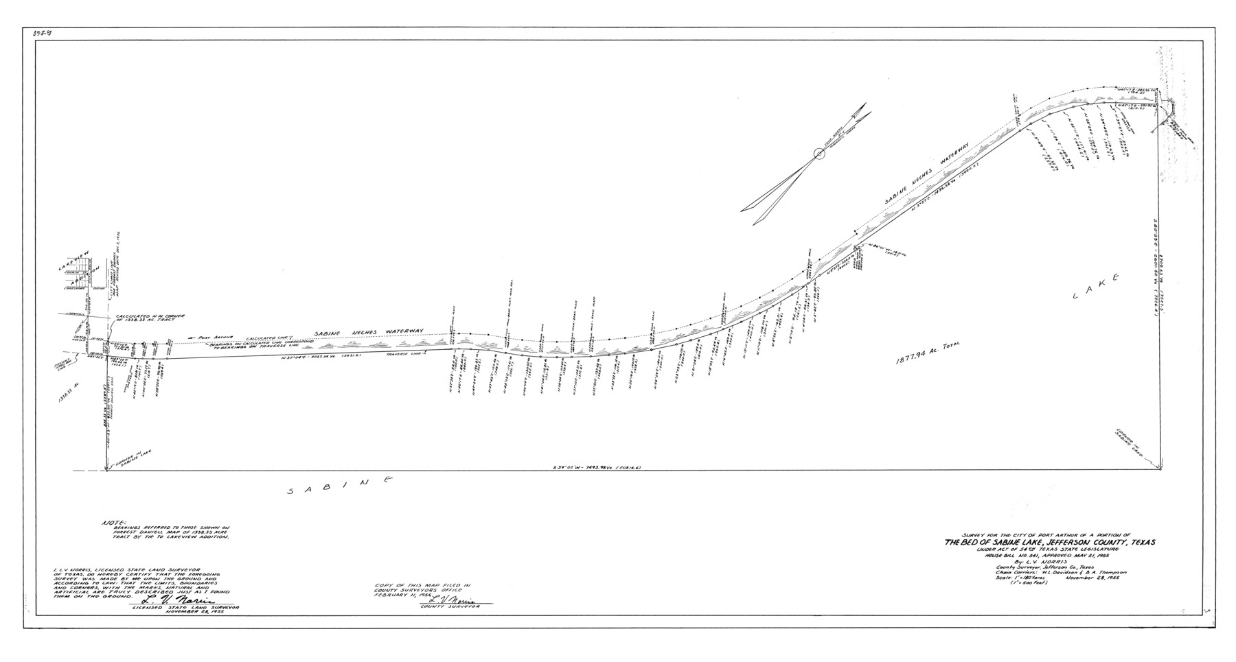
Survey for the City of Port Arthur of a portion of the bed of Sabine Lake, Jefferson County, Texas under Act of 54th Texas State Legislature, House Bill no. 541, approved May 21, 1955
-
Map/Doc
9295
-
Collection
General Map Collection
-
Object Dates
1955/11/28 (Creation Date)
1956/2/17 (File Date)
-
People and Organizations
W.L. Davidson (Chainman/Field Personnel)
B.A. Thompson (Chainman/Field Personnel)
L.V. Norris (Surveyor/Engineer)
-
Counties
Jefferson
-
Subjects
Surveying Rolled Sketch
-
Height x Width
26.4 x 49.3 inches
67.1 x 125.2 cm
-
Scale
1" = 180 varas
-
Comments
See Jefferson Scrip 598.
Part of: General Map Collection
The Great Texas Coastal Birding Trail, Central Texas Coast

The Great Texas Coastal Birding Trail, Central Texas Coast
Size 33.3 x 36.0 inches
Map/Doc 94340
Austin County Rolled Sketch 5A

Print $40.00
- Digital $50.00
Austin County Rolled Sketch 5A
Size 54.2 x 44.1 inches
Map/Doc 8437
[Sketch for Mineral Application 24072, San Jacinto River]
![65608, [Sketch for Mineral Application 24072, San Jacinto River], General Map Collection](https://historictexasmaps.com/wmedia_w700/maps/65608.tif.jpg)
Print $20.00
- Digital $50.00
[Sketch for Mineral Application 24072, San Jacinto River]
1929
Size 8.6 x 14.0 inches
Map/Doc 65608
Edwards County Sketch File 10

Print $40.00
- Digital $50.00
Edwards County Sketch File 10
Size 26.3 x 19.0 inches
Map/Doc 11421
Trinity County Sketch File 4

Print $24.00
- Digital $50.00
Trinity County Sketch File 4
1858
Size 8.4 x 7.7 inches
Map/Doc 38501
Leon County Working Sketch 18

Print $20.00
- Digital $50.00
Leon County Working Sketch 18
1960
Size 43.2 x 36.8 inches
Map/Doc 70417
Flight Mission No. CGI-3N, Frame 167, Cameron County

Print $20.00
- Digital $50.00
Flight Mission No. CGI-3N, Frame 167, Cameron County
1954
Size 18.6 x 22.4 inches
Map/Doc 84631

United States - Gulf Coast - Galveston to Rio Grande

Print $20.00
- Digital $50.00
United States - Gulf Coast - Galveston to Rio Grande
Size 27.9 x 18.3 inches
Map/Doc 72739
Map of Wilbarger County

Print $40.00
- Digital $50.00
Map of Wilbarger County
1887
Size 52.2 x 47.0 inches
Map/Doc 16926
Wood County Sketch File 5

Print $4.00
- Digital $50.00
Wood County Sketch File 5
1848
Size 10.7 x 9.0 inches
Map/Doc 40637
Hood County Boundary File 40

Print $44.00
- Digital $50.00
Hood County Boundary File 40
Size 14.4 x 8.8 inches
Map/Doc 55019
You may also like

Flight Mission No. DAG-17K, Frame 123, Matagorda County

Print $20.00
- Digital $50.00
Flight Mission No. DAG-17K, Frame 123, Matagorda County
1952
Size 18.6 x 22.3 inches
Map/Doc 86343
Parker County Sketch File 14

Print $20.00
- Digital $50.00
Parker County Sketch File 14
1853
Size 25.6 x 10.3 inches
Map/Doc 12143
McMullen County Working Sketch 62

Print $20.00
- Digital $50.00
McMullen County Working Sketch 62
2016
Size 24.1 x 36.1 inches
Map/Doc 94089
Angelina County Working Sketch 48

Print $20.00
- Digital $50.00
Angelina County Working Sketch 48
1980
Size 33.5 x 38.9 inches
Map/Doc 67131
Kendall County Sketch File 21

Print $20.00
- Digital $50.00
Kendall County Sketch File 21
1931
Size 17.9 x 22.7 inches
Map/Doc 11909
Fannin County Working Sketch 1

Print $20.00
- Digital $50.00
Fannin County Working Sketch 1
1904
Size 27.6 x 19.5 inches
Map/Doc 69155
Angelina County Sketch File 4

Print $4.00
- Digital $50.00
Angelina County Sketch File 4
1854
Size 8.3 x 9.0 inches
Map/Doc 12926
Scenes Around Carrizo Springs, Texas the Hub of the Winter Garden District

Print $20.00
- Digital $50.00
Scenes Around Carrizo Springs, Texas the Hub of the Winter Garden District
1920
Size 8.8 x 15.5 inches
Map/Doc 96767
S. M. S. Flat Top Ranch

Print $6.00
- Digital $50.00
S. M. S. Flat Top Ranch
1955
Size 23.2 x 32.8 inches
Map/Doc 2102
Houston Ship Channel, Alexander Island to Carpenter Bayou

Print $40.00
- Digital $50.00
Houston Ship Channel, Alexander Island to Carpenter Bayou
1992
Size 36.0 x 49.4 inches
Map/Doc 69918
