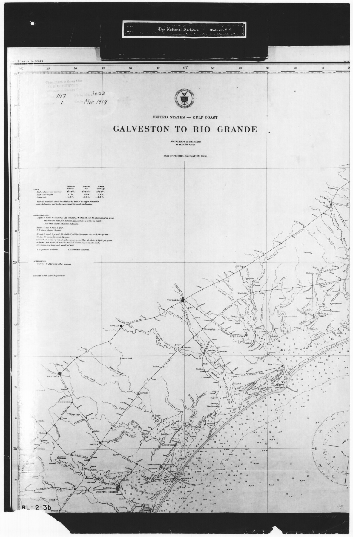
United States - Gulf Coast - Galveston to Rio Grande
RL-2-3a
-
Map/Doc
72739
-
Collection
General Map Collection
-
People and Organizations
U. S. Coast and Geodetic Survey (Publisher)
-
Subjects
Nautical Charts
-
Height x Width
27.9 x 18.3 inches
70.9 x 46.5 cm
-
Comments
B/W photostat copy from National Archives in multiple pieces.
Part of: General Map Collection
Liberty County Sketch File 29

Print $40.00
- Digital $50.00
Liberty County Sketch File 29
1888
Size 14.9 x 14.9 inches
Map/Doc 29955
Castro County Rolled Sketch 7

Print $20.00
- Digital $50.00
Castro County Rolled Sketch 7
1908
Size 28.9 x 24.1 inches
Map/Doc 5417
El Paso County

Print $40.00
- Digital $50.00
El Paso County
1881
Size 51.5 x 15.7 inches
Map/Doc 89057
Jeff Davis County Working Sketch 10

Print $20.00
- Digital $50.00
Jeff Davis County Working Sketch 10
1946
Size 29.3 x 37.0 inches
Map/Doc 66505
Padre Island National Seashore

Print $4.00
- Digital $50.00
Padre Island National Seashore
Size 16.1 x 22.3 inches
Map/Doc 60535
Montgomery County Sketch File 8

Print $4.00
- Digital $50.00
Montgomery County Sketch File 8
1862
Size 12.2 x 8.2 inches
Map/Doc 31793
Crane County Rolled Sketch 4

Print $40.00
- Digital $50.00
Crane County Rolled Sketch 4
Size 34.7 x 51.9 inches
Map/Doc 8337
Colorado County Working Sketch 27

Print $20.00
- Digital $50.00
Colorado County Working Sketch 27
1979
Size 29.1 x 23.3 inches
Map/Doc 68127
Kinney County Working Sketch 3

Print $20.00
- Digital $50.00
Kinney County Working Sketch 3
Size 20.3 x 17.6 inches
Map/Doc 70185
Montague County Working Sketch 29

Print $20.00
- Digital $50.00
Montague County Working Sketch 29
1972
Size 27.8 x 22.1 inches
Map/Doc 71095
Duval County Rolled Sketch 27

Print $40.00
- Digital $50.00
Duval County Rolled Sketch 27
Size 14.6 x 50.6 inches
Map/Doc 8814
Taylor County Rolled Sketch 27

Print $20.00
- Digital $50.00
Taylor County Rolled Sketch 27
Size 37.5 x 30.3 inches
Map/Doc 7918
You may also like
[T. A. Thomson Block T, R. M. Thomson Block 1, and Block B]
![91054, [T. A. Thomson Block T, R. M. Thomson Block 1, and Block B], Twichell Survey Records](https://historictexasmaps.com/wmedia_w700/maps/91054-1.tif.jpg)
Print $20.00
- Digital $50.00
[T. A. Thomson Block T, R. M. Thomson Block 1, and Block B]
Size 17.3 x 20.4 inches
Map/Doc 91054
West End of Copano Bay and Town of Saint Marys, Texas

Print $40.00
- Digital $50.00
West End of Copano Bay and Town of Saint Marys, Texas
1861
Size 54.5 x 32.9 inches
Map/Doc 73428
[Blocks DT, P, CK, C2, and D7]
![91307, [Blocks DT, P, CK, C2, and D7], Twichell Survey Records](https://historictexasmaps.com/wmedia_w700/maps/91307-1.tif.jpg)
Print $20.00
- Digital $50.00
[Blocks DT, P, CK, C2, and D7]
Size 23.6 x 9.6 inches
Map/Doc 91307
Pecos County Rolled Sketch 171

Print $20.00
- Digital $50.00
Pecos County Rolled Sketch 171
1975
Size 17.3 x 17.0 inches
Map/Doc 7293
Wharton County Rolled Sketch 8

Print $20.00
- Digital $50.00
Wharton County Rolled Sketch 8
Size 24.4 x 39.2 inches
Map/Doc 8232
Terrell County Sketch File 9

Print $12.00
- Digital $50.00
Terrell County Sketch File 9
Size 9.8 x 8.5 inches
Map/Doc 37904
Angelina County Sketch File 15c

Print $16.00
- Digital $50.00
Angelina County Sketch File 15c
1838
Size 12.2 x 8.0 inches
Map/Doc 12972
[F. W. & D. C. Ry. Co. Alignment and Right of Way Map, Clay County]
![64727, [F. W. & D. C. Ry. Co. Alignment and Right of Way Map, Clay County], General Map Collection](https://historictexasmaps.com/wmedia_w700/maps/64727-1.tif.jpg)
Print $20.00
- Digital $50.00
[F. W. & D. C. Ry. Co. Alignment and Right of Way Map, Clay County]
1927
Size 18.6 x 11.7 inches
Map/Doc 64727
General Highway Map. Detail of Cities and Towns in Nacogdoches County, Texas [Nacogdoches and vicinity]
![79609, General Highway Map. Detail of Cities and Towns in Nacogdoches County, Texas [Nacogdoches and vicinity], Texas State Library and Archives](https://historictexasmaps.com/wmedia_w700/maps/79609.tif.jpg)
Print $20.00
General Highway Map. Detail of Cities and Towns in Nacogdoches County, Texas [Nacogdoches and vicinity]
1961
Size 19.3 x 25.0 inches
Map/Doc 79609
Val Verde County Working Sketch 117

Print $20.00
- Digital $50.00
Val Verde County Working Sketch 117
1993
Size 34.8 x 37.0 inches
Map/Doc 82843
[Archer County School Land, Sections 1,2,3,4, Blocks GG, I, 29, A2, C3]
![92914, [Archer County School Land, Sections 1,2,3,4, Blocks GG, I, 29, A2, C3], Twichell Survey Records](https://historictexasmaps.com/wmedia_w700/maps/92914-1.tif.jpg)
Print $20.00
- Digital $50.00
[Archer County School Land, Sections 1,2,3,4, Blocks GG, I, 29, A2, C3]
Size 25.9 x 18.7 inches
Map/Doc 92914
[Sketch Showing Surveys in Dimmit County, Texas]
![5045, [Sketch Showing Surveys in Dimmit County, Texas], Maddox Collection](https://historictexasmaps.com/wmedia_w700/maps/5045.tif.jpg)
Print $20.00
- Digital $50.00
[Sketch Showing Surveys in Dimmit County, Texas]
Size 20.1 x 16.7 inches
Map/Doc 5045