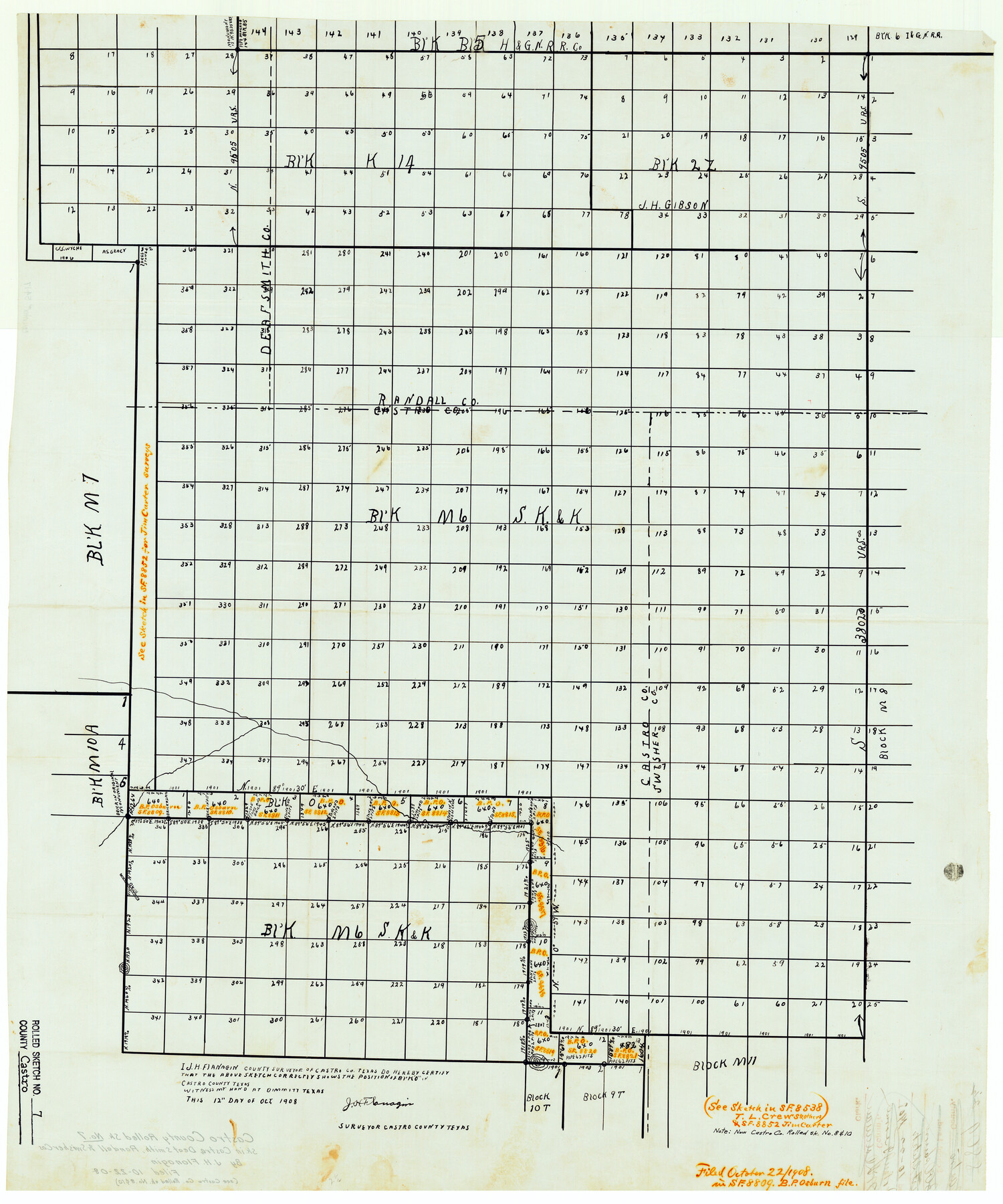
Castro County Rolled Sketch 7
[Sketch in Castro, Deaf Smith, Randall & Swisher Counties showing Block O]
-
Map/Doc
5417
-
Collection
General Map Collection
-
Object Dates
1908/10/22 (File Date)
1908/10/12 (Creation Date)
-
People and Organizations
J.H. Flanagin (Surveyor/Engineer)
-
Counties
Castro Deaf Smith Randall Swisher
-
Subjects
Surveying Rolled Sketch
-
Height x Width
28.9 x 24.1 inches
73.4 x 61.2 cm
-
Medium
linen, manuscript
-
Comments
See Castro County Rolled Sketches 8 (5418) and 10 (5419).
Related maps
Castro County Rolled Sketch 8

Print $20.00
- Digital $50.00
Castro County Rolled Sketch 8
Size 34.1 x 28.8 inches
Map/Doc 5418
Castro County Rolled Sketch 10

Print $20.00
- Digital $50.00
Castro County Rolled Sketch 10
1908
Size 30.6 x 8.9 inches
Map/Doc 5419
Part of: General Map Collection
Pecos County Rolled Sketch 161

Print $40.00
- Digital $50.00
Pecos County Rolled Sketch 161
Size 67.1 x 35.2 inches
Map/Doc 9740
Cooke County Sketch File 3a

Print $20.00
- Digital $50.00
Cooke County Sketch File 3a
Size 18.8 x 10.4 inches
Map/Doc 11170
Sutton County Rolled Sketch 66

Print $20.00
- Digital $50.00
Sutton County Rolled Sketch 66
Size 25.3 x 25.1 inches
Map/Doc 7901
Presidio County Rolled Sketch 96

Print $20.00
- Digital $50.00
Presidio County Rolled Sketch 96
Size 12.3 x 45.9 inches
Map/Doc 9782
Duval County Sketch File 85

Print $27.00
- Digital $50.00
Duval County Sketch File 85
1935
Size 14.3 x 9.1 inches
Map/Doc 21534
Wheeler County Working Sketch 11

Print $40.00
- Digital $50.00
Wheeler County Working Sketch 11
1973
Size 77.4 x 44.0 inches
Map/Doc 72500
Reagan County Working Sketch 12

Print $20.00
- Digital $50.00
Reagan County Working Sketch 12
1948
Size 24.1 x 44.9 inches
Map/Doc 71852
Map of Runnels County

Print $20.00
- Digital $50.00
Map of Runnels County
1898
Size 43.2 x 36.9 inches
Map/Doc 16803
Knox County Working Sketch 11

Print $20.00
- Digital $50.00
Knox County Working Sketch 11
1950
Size 16.8 x 29.0 inches
Map/Doc 70253
Coke County Sketch File 34

Print $20.00
- Digital $50.00
Coke County Sketch File 34
1888
Size 17.2 x 21.7 inches
Map/Doc 11116
Marion County Rolled Sketch 8

Print $20.00
- Digital $50.00
Marion County Rolled Sketch 8
1998
Size 33.0 x 22.1 inches
Map/Doc 6661
Washington County Sketch File 3

Print $4.00
- Digital $50.00
Washington County Sketch File 3
1860
Size 8.1 x 9.2 inches
Map/Doc 39648
You may also like
Llano County Sketch File 9

Print $42.00
- Digital $50.00
Llano County Sketch File 9
Size 8.6 x 13.1 inches
Map/Doc 30369
Flight Mission No. CRC-3R, Frame 15, Chambers County

Print $20.00
- Digital $50.00
Flight Mission No. CRC-3R, Frame 15, Chambers County
1956
Size 18.5 x 22.2 inches
Map/Doc 84789
Part of Matagorda Bay & Peninsula, Texas

Print $40.00
- Digital $50.00
Part of Matagorda Bay & Peninsula, Texas
1856
Size 31.8 x 51.4 inches
Map/Doc 69978
[Sketch for Mineral Application 26501 - Sabine River, T. A. Oldhausen]
![2838, [Sketch for Mineral Application 26501 - Sabine River, T. A. Oldhausen], General Map Collection](https://historictexasmaps.com/wmedia_w700/maps/2838.tif.jpg)
Print $20.00
- Digital $50.00
[Sketch for Mineral Application 26501 - Sabine River, T. A. Oldhausen]
1931
Size 24.3 x 36.1 inches
Map/Doc 2838
Coryell County Sketch File 8

Print $6.00
- Digital $50.00
Coryell County Sketch File 8
1853
Size 16.0 x 10.2 inches
Map/Doc 19357
Donley County Sketch File 28

Print $40.00
- Digital $50.00
Donley County Sketch File 28
Size 25.7 x 9.1 inches
Map/Doc 21266
Palo Pinto County, Texas

Print $20.00
- Digital $50.00
Palo Pinto County, Texas
1879
Size 17.8 x 19.0 inches
Map/Doc 529
San Augustine County Boundary File 1

Print $17.00
- Digital $50.00
San Augustine County Boundary File 1
Size 9.3 x 12.2 inches
Map/Doc 58540
[Capitol Leagues 225-238]
![90676, [Capitol Leagues 225-238], Twichell Survey Records](https://historictexasmaps.com/wmedia_w700/maps/90676-1.tif.jpg)
Print $20.00
- Digital $50.00
[Capitol Leagues 225-238]
Size 23.1 x 13.6 inches
Map/Doc 90676
Oldham County Sketch File 6

Print $20.00
- Digital $50.00
Oldham County Sketch File 6
1883
Size 31.4 x 42.8 inches
Map/Doc 10561
Atascosa County Rolled Sketch 18

Print $20.00
- Digital $50.00
Atascosa County Rolled Sketch 18
1955
Size 17.6 x 23.9 inches
Map/Doc 5098
"The Texas and Pacific Railway Company Reservation and Land Grant"

Print $38.00
- Digital $50.00
"The Texas and Pacific Railway Company Reservation and Land Grant"
1962
Size 9.3 x 6.5 inches
Map/Doc 62213