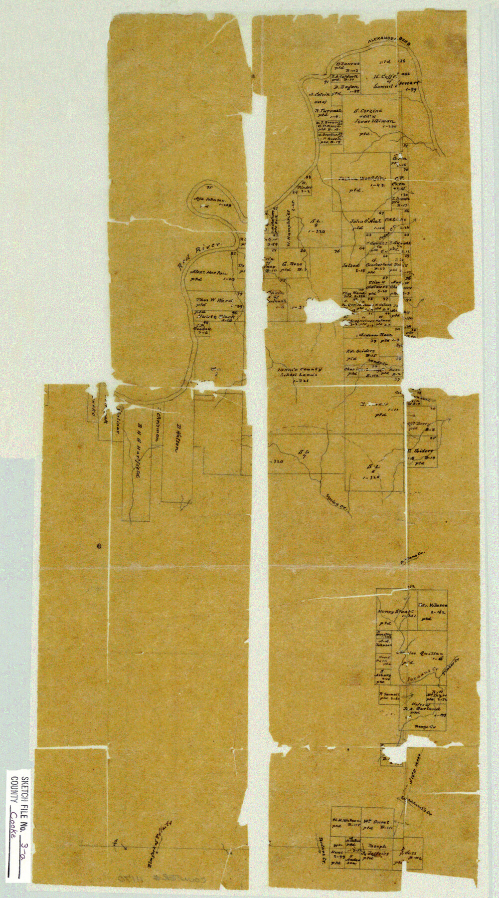
Cooke County Sketch File 3a
East part
-
Map/Doc
11170
-
Collection
General Map Collection
-
Counties
Cooke Denton Grayson
-
Subjects
Surveying Sketch File
-
Height x Width
18.8 x 10.4 inches
47.8 x 26.4 cm
-
Medium
paper, manuscript
-
Features
Alexander Bend [of Red River]
Red River
Spring Creek
Jordan's Creek
Timber Creek
Brian's Creek
Elm Fork of Trinity [River]
Part of: General Map Collection
Webb County Sketch File X

Print $32.00
- Digital $50.00
Webb County Sketch File X
1908
Size 11.2 x 9.0 inches
Map/Doc 39701
Presidio County Working Sketch 90

Print $20.00
- Digital $50.00
Presidio County Working Sketch 90
1973
Size 25.5 x 28.1 inches
Map/Doc 71767
Panola County Sketch File 26

Print $20.00
- Digital $50.00
Panola County Sketch File 26
1944
Size 28.5 x 27.1 inches
Map/Doc 12141
Shackelford County Boundary File 5

Print $14.00
- Digital $50.00
Shackelford County Boundary File 5
Size 8.6 x 14.0 inches
Map/Doc 58661
Flight Mission No. BRA-8M, Frame 118, Jefferson County

Print $20.00
- Digital $50.00
Flight Mission No. BRA-8M, Frame 118, Jefferson County
1953
Size 18.6 x 22.3 inches
Map/Doc 85614
Flight Mission No. DQO-7K, Frame 84, Galveston County

Print $20.00
- Digital $50.00
Flight Mission No. DQO-7K, Frame 84, Galveston County
1952
Size 18.8 x 22.5 inches
Map/Doc 85111
Flight Mission No. BRA-9M, Frame 70, Jefferson County

Print $20.00
- Digital $50.00
Flight Mission No. BRA-9M, Frame 70, Jefferson County
1953
Size 18.6 x 22.5 inches
Map/Doc 85653
[Cotton Belt, St. Louis Southwestern Railway of Texas, Alignment through Smith County]
![64386, [Cotton Belt, St. Louis Southwestern Railway of Texas, Alignment through Smith County], General Map Collection](https://historictexasmaps.com/wmedia_w700/maps/64386.tif.jpg)
Print $20.00
- Digital $50.00
[Cotton Belt, St. Louis Southwestern Railway of Texas, Alignment through Smith County]
1903
Size 21.7 x 29.3 inches
Map/Doc 64386
Flight Mission No. CGI-3N, Frame 77, Cameron County

Print $20.00
- Digital $50.00
Flight Mission No. CGI-3N, Frame 77, Cameron County
1954
Size 18.6 x 22.2 inches
Map/Doc 84571
Ward County Sketch File 11

Print $20.00
- Digital $50.00
Ward County Sketch File 11
1943
Size 17.4 x 20.4 inches
Map/Doc 12600
Sutton County Rolled Sketch F

Print $20.00
- Digital $50.00
Sutton County Rolled Sketch F
Size 12.7 x 38.9 inches
Map/Doc 7903
Carson County Boundary File 10

Print $2.00
- Digital $50.00
Carson County Boundary File 10
Size 11.5 x 7.2 inches
Map/Doc 51185
You may also like
Jackson County Working Sketch 14

Print $20.00
- Digital $50.00
Jackson County Working Sketch 14
1990
Size 31.7 x 32.2 inches
Map/Doc 66462
Montague County Boundary File 2a

Print $8.00
- Digital $50.00
Montague County Boundary File 2a
Size 13.0 x 8.3 inches
Map/Doc 57410
Right of Way and Track Map, International & Gt. Northern Ry. operated by the International & Gt. Northern Ry. Co. Gulf Division, Mineola Branch

Print $40.00
- Digital $50.00
Right of Way and Track Map, International & Gt. Northern Ry. operated by the International & Gt. Northern Ry. Co. Gulf Division, Mineola Branch
1917
Size 25.2 x 120.8 inches
Map/Doc 64703
Rio Grande Rectification Project, El Paso and Juarez Valley

Print $20.00
- Digital $50.00
Rio Grande Rectification Project, El Paso and Juarez Valley
1935
Size 11.0 x 29.6 inches
Map/Doc 60871
Hardin County Working Sketch 20

Print $20.00
- Digital $50.00
Hardin County Working Sketch 20
1947
Size 38.1 x 32.6 inches
Map/Doc 63418
Galveston County Rolled Sketch 20

Print $20.00
- Digital $50.00
Galveston County Rolled Sketch 20
1970
Size 35.0 x 35.0 inches
Map/Doc 9080
Township 2 North Range 12 West, North Western District, Louisiana

Print $20.00
- Digital $50.00
Township 2 North Range 12 West, North Western District, Louisiana
1884
Size 19.6 x 24.7 inches
Map/Doc 65875
Karnes County Sketch File 10

Print $10.00
- Digital $50.00
Karnes County Sketch File 10
1885
Size 12.8 x 8.5 inches
Map/Doc 28597
Zavala County Sketch File 5

Print $4.00
- Digital $50.00
Zavala County Sketch File 5
1876
Size 13.0 x 8.4 inches
Map/Doc 41263
Kinney County Rolled Sketch 16

Print $20.00
- Digital $50.00
Kinney County Rolled Sketch 16
1963
Size 37.4 x 44.7 inches
Map/Doc 9355
Controlled Mosaic by Jack Amman Photogrammetric Engineers, Inc - Sheet 17

Print $20.00
- Digital $50.00
Controlled Mosaic by Jack Amman Photogrammetric Engineers, Inc - Sheet 17
1954
Size 20.0 x 24.0 inches
Map/Doc 83461
Map of the East Part of Tom Green County

Print $20.00
- Digital $50.00
Map of the East Part of Tom Green County
1894
Size 21.5 x 23.1 inches
Map/Doc 4083