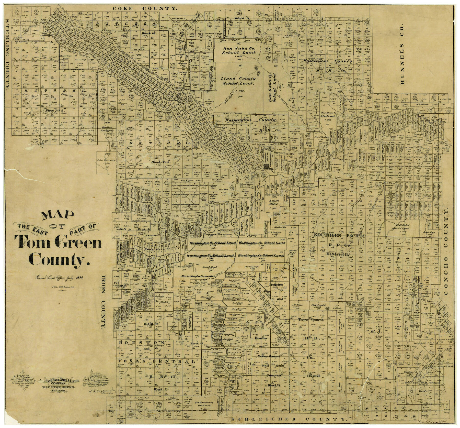
Map of the East Part of Tom Green County
-
Map/Doc
4083
-
Collection
General Map Collection
-
Object Dates
7/1894 (Creation Date)
-
People and Organizations
W.L. McGaughey (GLO Commissioner)
August Gast Bank Note & Lithograph Company (Lithographer)
-
Counties
Tom Green
-
Subjects
County
-
Height x Width
21.5 x 23.1 inches
54.6 x 58.7 cm
-
Comments
Copyrighted 1893.
-
Features
Mulberry Creek
Bald Eagle Creek
Tom Jeff Creek
Round Mountain
Valentin [sic] Creek
Adams Creek
San Angelo
Cottonwood Creek
Grisby Creek
Catelan Creek
Erica Creek
Burks Creek
Antelope Creek
Susan Peak
South Concho River
Kickapoo Creek
Part of: General Map Collection
Williamson County Working Sketch 17

Print $20.00
- Digital $50.00
Williamson County Working Sketch 17
1984
Size 32.7 x 24.0 inches
Map/Doc 72577
Wharton County Working Sketch Graphic Index

Print $20.00
- Digital $50.00
Wharton County Working Sketch Graphic Index
1946
Size 41.7 x 47.5 inches
Map/Doc 76737
Kleberg County Rolled Sketch 13

Print $20.00
- Digital $50.00
Kleberg County Rolled Sketch 13
1995
Size 39.3 x 33.8 inches
Map/Doc 6554
Refugio County Working Sketch 11

Print $20.00
- Digital $50.00
Refugio County Working Sketch 11
1942
Size 40.9 x 38.3 inches
Map/Doc 63520
Map of the Houston & Great Northern Railroad

Print $40.00
- Digital $50.00
Map of the Houston & Great Northern Railroad
1871
Size 29.3 x 122.1 inches
Map/Doc 64551
[Map of the dividing line between Milam and Travis Counties]
![110, [Map of the dividing line between Milam and Travis Counties], General Map Collection](https://historictexasmaps.com/wmedia_w700/maps/110.tif.jpg)
Print $20.00
- Digital $50.00
[Map of the dividing line between Milam and Travis Counties]
1841
Size 14.2 x 12.8 inches
Map/Doc 110
Rockwall County

Print $20.00
- Digital $50.00
Rockwall County
1941
Size 28.5 x 23.9 inches
Map/Doc 63006
Jefferson County Sketch File 9

Print $40.00
- Digital $50.00
Jefferson County Sketch File 9
1860
Size 12.6 x 15.2 inches
Map/Doc 28123
Chambers County NRC Article 33.136 Sketch 5

Print $22.00
- Digital $50.00
Chambers County NRC Article 33.136 Sketch 5
2003
Size 24.2 x 18.3 inches
Map/Doc 78608
Harris County Rolled Sketch 98

Print $20.00
- Digital $50.00
Harris County Rolled Sketch 98
1992
Size 27.1 x 39.5 inches
Map/Doc 6136
Kleberg County Rolled Sketch 10-13

Print $20.00
- Digital $50.00
Kleberg County Rolled Sketch 10-13
1952
Size 37.0 x 32.5 inches
Map/Doc 9391
Val Verde County Sketch File XXX2

Print $20.00
- Digital $50.00
Val Verde County Sketch File XXX2
Size 18.6 x 17.9 inches
Map/Doc 12548
You may also like
Caldwell County Working Sketch 10

Print $40.00
- Digital $50.00
Caldwell County Working Sketch 10
1977
Size 46.2 x 50.5 inches
Map/Doc 67840
Kendall County Working Sketch 1

Print $20.00
- Digital $50.00
Kendall County Working Sketch 1
1911
Size 18.8 x 17.6 inches
Map/Doc 66673
[Surveys Surrounding I. G. Yates S.F. 12394]
![91560, [Surveys Surrounding I. G. Yates S.F. 12394], Twichell Survey Records](https://historictexasmaps.com/wmedia_w700/maps/91560-1.tif.jpg)
Print $20.00
- Digital $50.00
[Surveys Surrounding I. G. Yates S.F. 12394]
Size 18.6 x 7.4 inches
Map/Doc 91560
Midland County Rolled Sketch T

Print $20.00
- Digital $50.00
Midland County Rolled Sketch T
1933
Size 15.9 x 21.4 inches
Map/Doc 6772
Coryell County Working Sketch 26

Print $20.00
- Digital $50.00
Coryell County Working Sketch 26
1988
Size 30.7 x 30.6 inches
Map/Doc 68233
Southern Pacific Rice Belt

Print $40.00
- Digital $50.00
Southern Pacific Rice Belt
Size 31.6 x 57.9 inches
Map/Doc 96793
Pecos County Rolled Sketch 177

Print $20.00
- Digital $50.00
Pecos County Rolled Sketch 177
1972
Size 27.4 x 38.0 inches
Map/Doc 7297
Hemphill County

Print $20.00
- Digital $50.00
Hemphill County
1888
Size 23.9 x 18.3 inches
Map/Doc 3653
Morris County Rolled Sketch 2A

Print $20.00
- Digital $50.00
Morris County Rolled Sketch 2A
Size 36.0 x 25.0 inches
Map/Doc 10236
Mills County Boundary File 8

Print $10.00
- Digital $50.00
Mills County Boundary File 8
Size 14.2 x 8.7 inches
Map/Doc 57313
Nolan County Sketch File A

Print $20.00
- Digital $50.00
Nolan County Sketch File A
Size 22.4 x 19.9 inches
Map/Doc 42170
Limestone County Working Sketch 1

Print $20.00
- Digital $50.00
Limestone County Working Sketch 1
Size 15.4 x 13.0 inches
Map/Doc 70551