Kleberg County Rolled Sketch 10-13
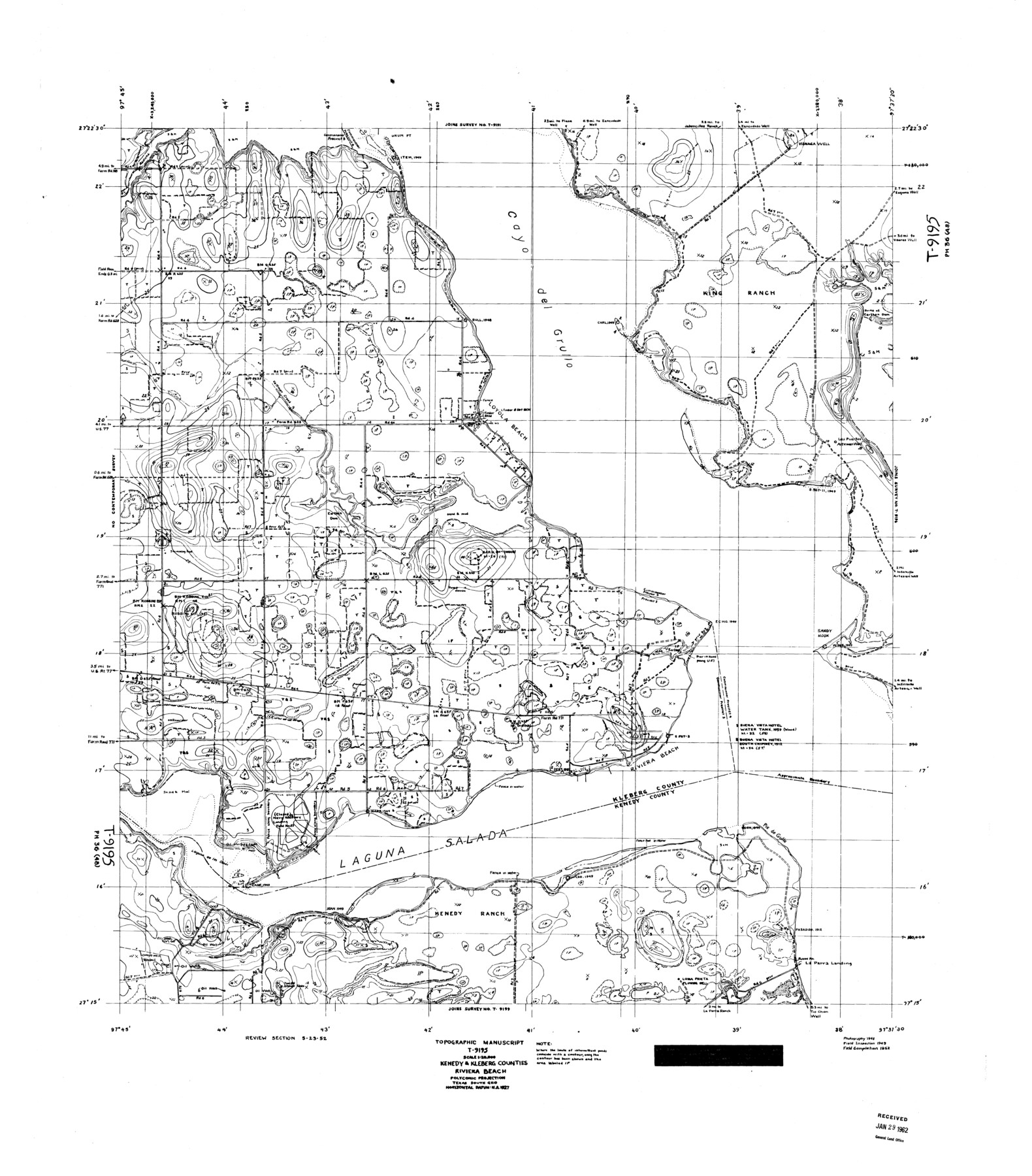
Topographic Manuscript T-9195, Kenedy & Kleberg Counties, Riviera Beach
-
Map/Doc
9391
-
Collection
General Map Collection
-
Object Dates
1952 (Creation Date)
1962/1/29 (File Date)
-
Counties
Kleberg Kenedy
-
Subjects
Surveying Rolled Sketch
-
Height x Width
37.0 x 32.5 inches
94.0 x 82.6 cm
Part of: General Map Collection
Garza County Sketch File 30

Print $8.00
- Digital $50.00
Garza County Sketch File 30
1959
Size 14.3 x 8.8 inches
Map/Doc 24100
Webb County Rolled Sketch EF1

Print $20.00
- Digital $50.00
Webb County Rolled Sketch EF1
1931
Size 40.3 x 30.0 inches
Map/Doc 8223
Colorado River, Lane City Sheet

Print $4.00
- Digital $50.00
Colorado River, Lane City Sheet
1941
Size 27.0 x 29.9 inches
Map/Doc 65316
Palo Pinto County Sketch File A

Print $6.00
- Digital $50.00
Palo Pinto County Sketch File A
Size 8.7 x 4.1 inches
Map/Doc 33389

Brewster County Working Sketch 102

Print $20.00
- Digital $50.00
Brewster County Working Sketch 102
1980
Size 40.0 x 43.3 inches
Map/Doc 67702

Harris County Sketch File 80a

Print $20.00
- Digital $50.00
Harris County Sketch File 80a
1892
Size 27.8 x 17.6 inches
Map/Doc 11667
Lubbock County Boundary File 11

Print $68.00
- Digital $50.00
Lubbock County Boundary File 11
Size 14.7 x 9.2 inches
Map/Doc 56583
Travis County Working Sketch 21

Print $20.00
- Digital $50.00
Travis County Working Sketch 21
1946
Size 35.6 x 42.7 inches
Map/Doc 69405
Winkler County Working Sketch 16

Print $20.00
- Digital $50.00
Winkler County Working Sketch 16
1964
Size 27.7 x 35.8 inches
Map/Doc 72610
Calhoun County Rolled Sketch 14

Print $20.00
- Digital $50.00
Calhoun County Rolled Sketch 14
Size 21.8 x 40.2 inches
Map/Doc 5458
You may also like
Kerr County Working Sketch 6

Print $20.00
- Digital $50.00
Kerr County Working Sketch 6
1947
Size 32.8 x 26.3 inches
Map/Doc 70037
Pecos County Rolled Sketch 148

Print $20.00
- Digital $50.00
Pecos County Rolled Sketch 148
Size 30.3 x 42.6 inches
Map/Doc 7279
Working Sketch of Surveys in Presidio County in the area east of Shafter, Texas

Print $20.00
- Digital $50.00
Working Sketch of Surveys in Presidio County in the area east of Shafter, Texas
1947
Size 37.5 x 40.1 inches
Map/Doc 89889
Leon County Working Sketch 19

Print $20.00
- Digital $50.00
Leon County Working Sketch 19
1962
Size 31.2 x 31.4 inches
Map/Doc 70418
Roberts County Working Sketch 44

Print $20.00
- Digital $50.00
Roberts County Working Sketch 44
1991
Size 26.8 x 42.6 inches
Map/Doc 63570
[Marion County School Land, Jack County School Land, Abel A. Lewis and other surveys in vicinity]
![90427, [Marion County School Land, Jack County School Land, Abel A. Lewis and other surveys in vicinity], Twichell Survey Records](https://historictexasmaps.com/wmedia_w700/maps/90427-1.tif.jpg)
Print $20.00
- Digital $50.00
[Marion County School Land, Jack County School Land, Abel A. Lewis and other surveys in vicinity]
Size 22.0 x 25.1 inches
Map/Doc 90427
Young County Working Sketch Graphic Index

Print $20.00
- Digital $50.00
Young County Working Sketch Graphic Index
1941
Size 44.1 x 38.4 inches
Map/Doc 76748
[Township 4 North, Block 33]
![91216, [Township 4 North, Block 33], Twichell Survey Records](https://historictexasmaps.com/wmedia_w700/maps/91216-1.tif.jpg)
Print $3.00
- Digital $50.00
[Township 4 North, Block 33]
Size 11.3 x 12.0 inches
Map/Doc 91216

Culberson County Rolled Sketch 54

Print $40.00
- Digital $50.00
Culberson County Rolled Sketch 54
1968
Size 59.0 x 29.4 inches
Map/Doc 10300
Working Sketch Bastrop County

Print $3.00
- Digital $50.00
Working Sketch Bastrop County
1923
Size 11.0 x 16.2 inches
Map/Doc 90207
Crockett County Sketch File 8 (1)

Print $6.00
- Digital $50.00
Crockett County Sketch File 8 (1)
1858
Size 9.8 x 4.6 inches
Map/Doc 19652