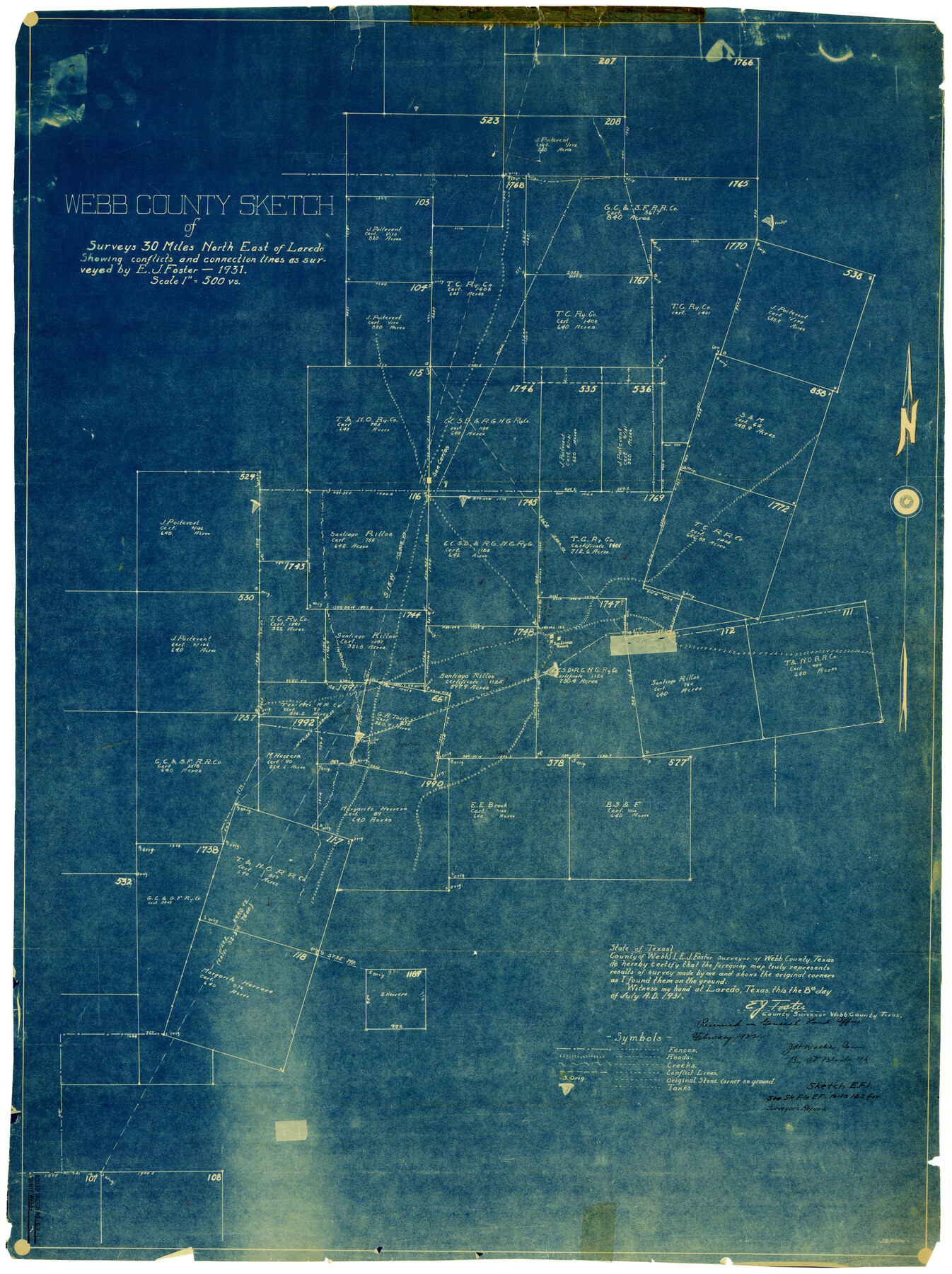
Webb County Rolled Sketch EF1
Webb County sketch of surveys 30 miles north east of Laredo showing conflicts and connection lines as surveyed
-
Map/Doc
8223
-
Collection
General Map Collection
-
Object Dates
7/8/1931 (Creation Date)
2/1932 (File Date)
-
People and Organizations
E.J. Foster (Surveyor/Engineer)
-
Counties
Webb
-
Subjects
Surveying Rolled Sketch
-
Height x Width
40.3 x 30.0 inches
102.4 x 76.2 cm
-
Medium
blueprint/diazo
-
Scale
1" = 500 varas
-
Comments
See Webb County Sketch File EF (39681) for report.
Related maps
Webb County Sketch File EF

Print $38.00
- Digital $50.00
Webb County Sketch File EF
1932
Size 9.2 x 8.5 inches
Map/Doc 39681
Part of: General Map Collection

McMullen County Working Sketch 7

Print $20.00
- Digital $50.00
McMullen County Working Sketch 7
1926
Size 20.7 x 17.5 inches
Map/Doc 70708
Potter County Sketch File 21

Print $6.00
- Digital $50.00
Potter County Sketch File 21
1930
Size 14.1 x 9.7 inches
Map/Doc 34413
Montgomery County Working Sketch 62

Print $20.00
- Digital $50.00
Montgomery County Working Sketch 62
1963
Size 18.1 x 21.3 inches
Map/Doc 71169
Tyler County Working Sketch 13

Print $20.00
- Digital $50.00
Tyler County Working Sketch 13
1957
Size 34.5 x 38.5 inches
Map/Doc 69483
Erath County Working Sketch 48

Print $20.00
- Digital $50.00
Erath County Working Sketch 48
1989
Size 36.5 x 47.6 inches
Map/Doc 69129
Bowie County Sketch File 10

Print $8.00
- Digital $50.00
Bowie County Sketch File 10
1992
Size 11.1 x 8.8 inches
Map/Doc 14912
Cherokee County Sketch File 17

Print $6.00
- Digital $50.00
Cherokee County Sketch File 17
1862
Size 11.6 x 7.7 inches
Map/Doc 18156
Traced from Genl. Arista's map captured by the American Army under Genl. Taylor at Resaca de la Palma 9th May '46 and presented to James K. Polk, President U. States

Print $20.00
- Digital $50.00
Traced from Genl. Arista's map captured by the American Army under Genl. Taylor at Resaca de la Palma 9th May '46 and presented to James K. Polk, President U. States
1846
Size 18.2 x 27.4 inches
Map/Doc 73061
Childress County Rolled Sketch 11

Print $20.00
- Digital $50.00
Childress County Rolled Sketch 11
1940
Size 45.3 x 12.0 inches
Map/Doc 8602
Potter County Working Sketch 14

Print $20.00
- Digital $50.00
Potter County Working Sketch 14
1982
Size 33.7 x 32.6 inches
Map/Doc 71674
Galveston County NRC Article 33.136 Sketch 55B

Print $24.00
- Digital $50.00
Galveston County NRC Article 33.136 Sketch 55B
2007
Size 24.0 x 36.0 inches
Map/Doc 94666
You may also like
Flight Mission No. BQR-13K, Frame 27, Brazoria County

Print $20.00
- Digital $50.00
Flight Mission No. BQR-13K, Frame 27, Brazoria County
1952
Size 18.7 x 22.5 inches
Map/Doc 84075
Hudspeth County Rolled Sketch 72

Print $40.00
- Digital $50.00
Hudspeth County Rolled Sketch 72
1992
Size 36.7 x 49.0 inches
Map/Doc 9235

[Note to Thos. W. Ward to make corrections for J. D. Wheeler, Survey 147 in San Patricio County, San Patricio District]
![69748, [Note to Thos. W. Ward to make corrections for J. D. Wheeler, Survey 147 in San Patricio County, San Patricio District], General Map Collection](https://historictexasmaps.com/wmedia_w700/maps/69748.tif.jpg)
Print $2.00
- Digital $50.00
[Note to Thos. W. Ward to make corrections for J. D. Wheeler, Survey 147 in San Patricio County, San Patricio District]
1842
Size 4.5 x 6.8 inches
Map/Doc 69748
Lamb County Rolled Sketch 8

Print $20.00
- Digital $50.00
Lamb County Rolled Sketch 8
1910
Size 40.1 x 32.8 inches
Map/Doc 10728
Colorado County Working Sketch 11

Print $3.00
- Digital $50.00
Colorado County Working Sketch 11
1942
Size 10.6 x 16.5 inches
Map/Doc 68111
Flight Mission No. DQO-7K, Frame 78, Galveston County

Print $20.00
- Digital $50.00
Flight Mission No. DQO-7K, Frame 78, Galveston County
1952
Size 18.8 x 22.4 inches
Map/Doc 85105
Val Verde County Working Sketch 34

Print $20.00
- Digital $50.00
Val Verde County Working Sketch 34
1940
Size 33.7 x 27.9 inches
Map/Doc 72169
McMullen County Sketch File 22

Print $4.00
- Digital $50.00
McMullen County Sketch File 22
Size 10.0 x 8.1 inches
Map/Doc 31377
Val Verde County Working Sketch 58

Print $20.00
- Digital $50.00
Val Verde County Working Sketch 58
1958
Size 21.0 x 22.8 inches
Map/Doc 72193
Knox County Working Sketch 7

Print $3.00
- Digital $50.00
Knox County Working Sketch 7
1941
Size 11.1 x 9.1 inches
Map/Doc 70249
The Chief Justice County of Liberty. Lands in Conflict with Harrisburg County

Print $20.00
The Chief Justice County of Liberty. Lands in Conflict with Harrisburg County
2020
Size 20.5 x 21.7 inches
Map/Doc 96056