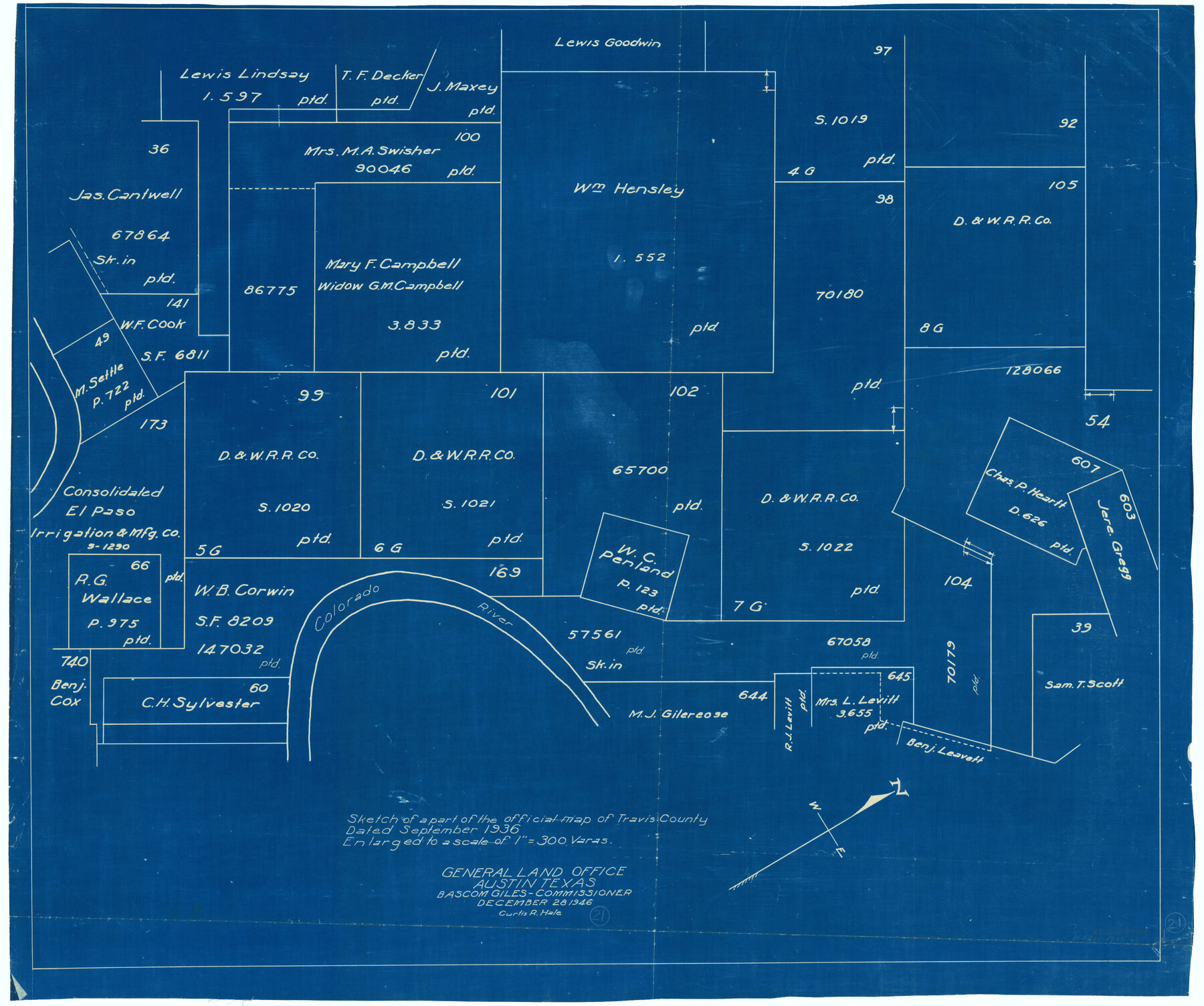
Travis County Working Sketch 21
-
Map/Doc
69405
-
Collection
General Map Collection
-
Object Dates
12/28/1946 (Creation Date)
-
People and Organizations
Curtis R. Hale (Draftsman)
-
Counties
Travis
-
Subjects
Surveying Working Sketch
-
Height x Width
35.6 x 42.7 inches
90.4 x 108.5 cm
-
Scale
1" = 300 varas
Part of: General Map Collection
Flight Mission No. DIX-7P, Frame 21, Aransas County

Print $20.00
- Digital $50.00
Flight Mission No. DIX-7P, Frame 21, Aransas County
1956
Size 18.8 x 22.6 inches
Map/Doc 83873
Live Oak County Working Sketch 32

Print $20.00
- Digital $50.00
Live Oak County Working Sketch 32
1992
Size 12.0 x 16.7 inches
Map/Doc 70617
Leon County Sketch File 36

Print $6.00
- Digital $50.00
Leon County Sketch File 36
1994
Size 14.2 x 8.7 inches
Map/Doc 29850
West Part Houston Co.

Print $20.00
- Digital $50.00
West Part Houston Co.
1944
Size 47.2 x 41.6 inches
Map/Doc 77317
[Map of Texas and Pacific Blocks from Brazos River westward through Palo Pinto, Stephens, Shackelford, Jones, Callahan, Taylor, Fisher, Nolan and Mitchell Counties]
![64510, [Map of Texas and Pacific Blocks from Brazos River westward through Palo Pinto, Stephens, Shackelford, Jones, Callahan, Taylor, Fisher, Nolan and Mitchell Counties], General Map Collection](https://historictexasmaps.com/wmedia_w700/maps/64510-1.tif.jpg)
Print $20.00
- Digital $50.00
[Map of Texas and Pacific Blocks from Brazos River westward through Palo Pinto, Stephens, Shackelford, Jones, Callahan, Taylor, Fisher, Nolan and Mitchell Counties]
Size 35.5 x 19.0 inches
Map/Doc 64510

Gaines County Boundary File 1

Print $90.00
- Digital $50.00
Gaines County Boundary File 1
Size 14.4 x 9.0 inches
Map/Doc 53626
A Map of that part of Young District south of old Fannin District line

Print $20.00
- Digital $50.00
A Map of that part of Young District south of old Fannin District line
1861
Size 24.9 x 38.0 inches
Map/Doc 1979
Brewster County Working Sketch 67

Print $20.00
- Digital $50.00
Brewster County Working Sketch 67
1958
Size 41.9 x 42.0 inches
Map/Doc 67668
Flight Mission No. DCL-7C, Frame 136, Kenedy County

Print $20.00
- Digital $50.00
Flight Mission No. DCL-7C, Frame 136, Kenedy County
1943
Size 18.6 x 22.3 inches
Map/Doc 86093
Red River County Working Sketch 82

Print $20.00
- Digital $50.00
Red River County Working Sketch 82
1996
Size 21.9 x 30.6 inches
Map/Doc 72068
Blanco County Working Sketch 17

Print $20.00
- Digital $50.00
Blanco County Working Sketch 17
1954
Size 31.6 x 30.3 inches
Map/Doc 67377
You may also like
Brewster County Sketch File N-6

Print $40.00
- Digital $50.00
Brewster County Sketch File N-6
1914
Size 15.8 x 12.7 inches
Map/Doc 10963
[Bastrop District]
![3131, [Bastrop District], General Map Collection](https://historictexasmaps.com/wmedia_w700/maps/3131.tif.jpg)
Print $40.00
- Digital $50.00
[Bastrop District]
1895
Size 36.5 x 52.0 inches
Map/Doc 3131
Map of the First Division of the Chicago, Texas & Mexican-Central Railway

Print $40.00
- Digital $50.00
Map of the First Division of the Chicago, Texas & Mexican-Central Railway
Size 26.1 x 96.3 inches
Map/Doc 64467
Culberson County Sketch File 3

Print $58.00
- Digital $50.00
Culberson County Sketch File 3
Size 8.0 x 3.3 inches
Map/Doc 20112
The Star of Llano County

Price $20.00
The Star of Llano County
2023
Size 3.3 x 2.8 inches
Map/Doc 97175
Zavala County Sketch File 11b

Print $4.00
- Digital $50.00
Zavala County Sketch File 11b
1886
Size 10.2 x 8.3 inches
Map/Doc 41277
Polk County Boundary File 70

Print $12.00
- Digital $50.00
Polk County Boundary File 70
Size 8.2 x 3.6 inches
Map/Doc 57930

Lee County Working Sketch 7

Print $20.00
- Digital $50.00
Lee County Working Sketch 7
1977
Size 27.0 x 16.8 inches
Map/Doc 70386
Shackelford County

Print $20.00
- Digital $50.00
Shackelford County
1972
Size 43.9 x 37.3 inches
Map/Doc 95638
Lampasas County Rolled Sketch 4

Print $20.00
- Digital $50.00
Lampasas County Rolled Sketch 4
2001
Size 27.1 x 38.5 inches
Map/Doc 6566
Nueces County Sketch File 17

Print $20.00
- Digital $50.00
Nueces County Sketch File 17
1854
Size 24.8 x 26.6 inches
Map/Doc 42180