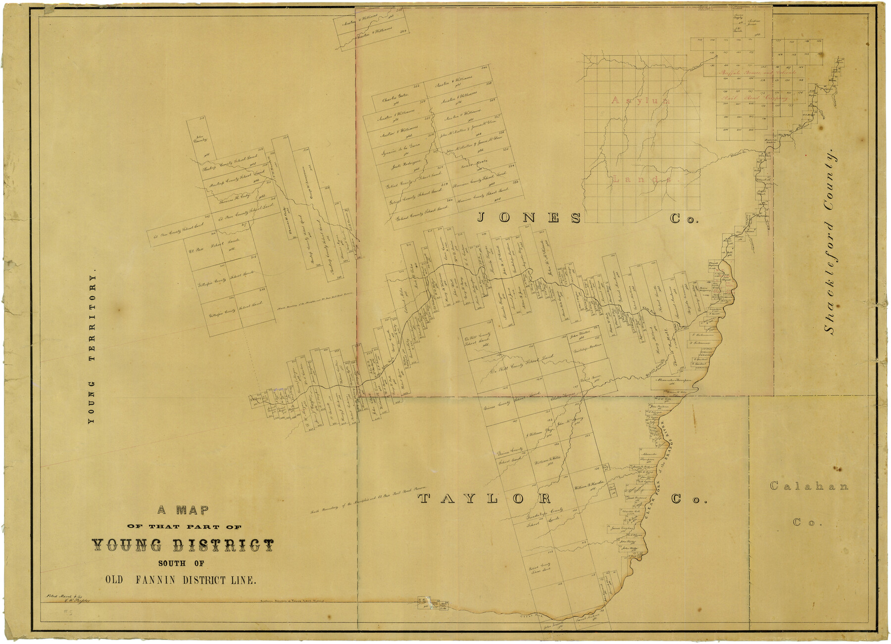
A Map of that part of Young District south of old Fannin District line
N-2-51
-
Map/Doc
1979
-
Collection
General Map Collection
-
Object Dates
1861 (Creation Date)
3/4/1861 (File Date)
-
People and Organizations
Chas. W. Pressler (Draftsman)
-
Counties
Jones Taylor Shackelford
-
Subjects
District
-
Height x Width
24.9 x 38.0 inches
63.3 x 96.5 cm
-
Scale
No scale given
-
Comments
Showing surveys in Jones and Taylor Counties; surveys west and north of the Clear Fork of the Brazos.
Part of: General Map Collection
Dallas County Sketch File 7

Print $4.00
- Digital $50.00
Dallas County Sketch File 7
1858
Size 10.4 x 8.5 inches
Map/Doc 20408
Flight Mission No. DAG-22K, Frame 83, Matagorda County

Print $20.00
- Digital $50.00
Flight Mission No. DAG-22K, Frame 83, Matagorda County
1953
Size 18.5 x 18.7 inches
Map/Doc 86467
McMullen County Sketch File 6

Print $4.00
- Digital $50.00
McMullen County Sketch File 6
Size 7.1 x 5.4 inches
Map/Doc 31345
Tarrant County Working Sketch 3

Print $20.00
- Digital $50.00
Tarrant County Working Sketch 3
1948
Size 26.3 x 24.9 inches
Map/Doc 62420
Victoria County Working Sketch 7

Print $40.00
- Digital $50.00
Victoria County Working Sketch 7
1945
Size 55.3 x 18.0 inches
Map/Doc 72277
Hartley County Sketch File 1a

Print $4.00
- Digital $50.00
Hartley County Sketch File 1a
1890
Size 7.8 x 8.2 inches
Map/Doc 26083
Armstrong County Sketch File 7

Print $6.00
- Digital $50.00
Armstrong County Sketch File 7
1902
Size 11.1 x 8.6 inches
Map/Doc 13702
[Gulf, Colorado & Santa Fe]
![64592, [Gulf, Colorado & Santa Fe], General Map Collection](https://historictexasmaps.com/wmedia_w700/maps/64592.tif.jpg)
Print $40.00
- Digital $50.00
[Gulf, Colorado & Santa Fe]
1918
Size 33.2 x 110.5 inches
Map/Doc 64592
Angelina County Sketch File 11e

Print $6.00
- Digital $50.00
Angelina County Sketch File 11e
1885
Size 12.7 x 8.2 inches
Map/Doc 12951
Andrews County Rolled Sketch 13

Print $20.00
- Digital $50.00
Andrews County Rolled Sketch 13
1934
Size 38.3 x 26.2 inches
Map/Doc 77163
Coke County Working Sketch 1

Print $20.00
- Digital $50.00
Coke County Working Sketch 1
Size 16.3 x 36.2 inches
Map/Doc 68038
Jeff Davis County Rolled Sketch 16

Print $20.00
- Digital $50.00
Jeff Davis County Rolled Sketch 16
Size 27.1 x 31.7 inches
Map/Doc 6369
You may also like
Coke County Rolled Sketch 9

Print $20.00
- Digital $50.00
Coke County Rolled Sketch 9
Size 25.7 x 20.7 inches
Map/Doc 5508
Travis County

Print $40.00
- Digital $50.00
Travis County
1936
Size 45.6 x 55.8 inches
Map/Doc 63077
Reagan County Working Sketch 20

Print $40.00
- Digital $50.00
Reagan County Working Sketch 20
1954
Size 37.5 x 68.2 inches
Map/Doc 71862
Panola County Rolled Sketch 2

Print $20.00
- Digital $50.00
Panola County Rolled Sketch 2
1944
Size 20.7 x 27.0 inches
Map/Doc 7197
[Sketch for Mineral Application 27670 - Strip between Simon Sanchez leagues and Trinity River]
![65646, [Sketch for Mineral Application 27670 - Strip between Simon Sanchez leagues and Trinity River], General Map Collection](https://historictexasmaps.com/wmedia_w700/maps/65646.tif.jpg)
Print $40.00
- Digital $50.00
[Sketch for Mineral Application 27670 - Strip between Simon Sanchez leagues and Trinity River]
Size 55.5 x 17.8 inches
Map/Doc 65646
[Sketch showing details along East line of Lipscomb County]
![89939, [Sketch showing details along East line of Lipscomb County], Twichell Survey Records](https://historictexasmaps.com/wmedia_w700/maps/89939-1.tif.jpg)
Print $40.00
- Digital $50.00
[Sketch showing details along East line of Lipscomb County]
Size 15.4 x 66.7 inches
Map/Doc 89939
Harris County Rolled Sketch 80A

Print $40.00
- Digital $50.00
Harris County Rolled Sketch 80A
Size 42.8 x 52.6 inches
Map/Doc 9136
Reeves County Working Sketch 51

Print $20.00
- Digital $50.00
Reeves County Working Sketch 51
1974
Size 45.4 x 34.6 inches
Map/Doc 63494
North Sulphur River, Kinsing Sheet

Print $20.00
- Digital $50.00
North Sulphur River, Kinsing Sheet
1925
Size 30.5 x 40.8 inches
Map/Doc 65165
Williamson County Sketch File 16

Print $20.00
- Digital $50.00
Williamson County Sketch File 16
Size 16.8 x 25.5 inches
Map/Doc 12693
Kerr County Rolled Sketch 11

Print $20.00
- Digital $50.00
Kerr County Rolled Sketch 11
1950
Size 28.1 x 36.9 inches
Map/Doc 6495
Hays County Working Sketch 13

Print $20.00
- Digital $50.00
Hays County Working Sketch 13
1952
Size 24.2 x 35.0 inches
Map/Doc 66087