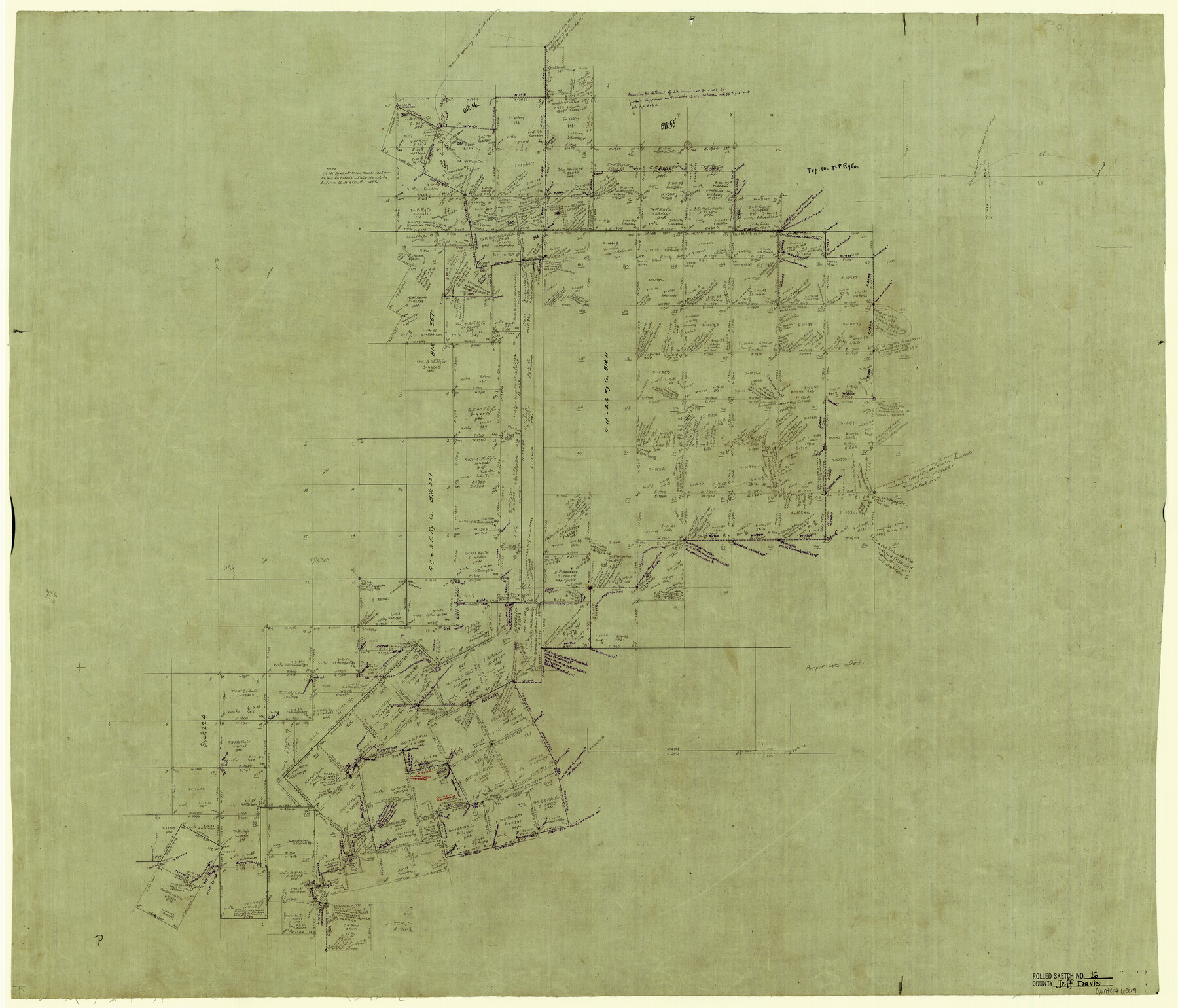
Jeff Davis County Rolled Sketch 16
[Working sketch NE of Ft. Davis]
-
Map/Doc
6369
-
Collection
General Map Collection
-
Counties
Jeff Davis Reeves
-
Subjects
Surveying Rolled Sketch
-
Height x Width
27.1 x 31.7 inches
68.8 x 80.5 cm
-
Medium
linen, manuscript
Part of: General Map Collection
Bosque County Working Sketch 16

Print $20.00
- Digital $50.00
Bosque County Working Sketch 16
1974
Size 40.5 x 33.2 inches
Map/Doc 67449
Ward County Sketch File 7

Print $4.00
- Digital $50.00
Ward County Sketch File 7
1927
Size 9.8 x 8.6 inches
Map/Doc 39621
Upton County Rolled Sketch 35

Print $20.00
- Digital $50.00
Upton County Rolled Sketch 35
1951
Size 37.3 x 19.2 inches
Map/Doc 8077
Starr County Boundary File 99

Print $56.00
- Digital $50.00
Starr County Boundary File 99
Size 9.2 x 6.2 inches
Map/Doc 58846
Hardin County Working Sketch 20

Print $20.00
- Digital $50.00
Hardin County Working Sketch 20
1947
Size 38.1 x 32.6 inches
Map/Doc 63418
Eastland County Working Sketch 20

Print $20.00
- Digital $50.00
Eastland County Working Sketch 20
1920
Size 38.0 x 23.5 inches
Map/Doc 68801
Flight Mission No. DAG-16K, Frame 70, Matagorda County

Print $20.00
- Digital $50.00
Flight Mission No. DAG-16K, Frame 70, Matagorda County
1952
Size 17.3 x 17.1 inches
Map/Doc 86316
Grimes County Working Sketch 14

Print $20.00
- Digital $50.00
Grimes County Working Sketch 14
1983
Size 33.0 x 34.1 inches
Map/Doc 63305
Wheeler County Working Sketch 19

Print $20.00
- Digital $50.00
Wheeler County Working Sketch 19
1986
Size 33.5 x 31.8 inches
Map/Doc 72508
Cameron County Sketch File 5

Print $4.00
- Digital $50.00
Cameron County Sketch File 5
1978
Size 11.1 x 8.7 inches
Map/Doc 17030
Motley County Sketch File B (S)

Print $40.00
- Digital $50.00
Motley County Sketch File B (S)
Size 14.2 x 12.4 inches
Map/Doc 32157
San Luis Pass to East Matagorda Bay

Print $40.00
- Digital $50.00
San Luis Pass to East Matagorda Bay
1982
Size 35.6 x 49.3 inches
Map/Doc 69970
You may also like
Upton County Working Sketch 41

Print $40.00
- Digital $50.00
Upton County Working Sketch 41
1960
Size 40.4 x 54.2 inches
Map/Doc 69537
Fort Bend County Working Sketch 15

Print $20.00
- Digital $50.00
Fort Bend County Working Sketch 15
1950
Size 22.5 x 14.7 inches
Map/Doc 69221
Karnes County Sketch File 2

Print $6.00
- Digital $50.00
Karnes County Sketch File 2
1851
Size 12.5 x 8.1 inches
Map/Doc 28547
Terry County Rolled Sketch 6

Print $20.00
- Digital $50.00
Terry County Rolled Sketch 6
1944
Size 36.5 x 43.7 inches
Map/Doc 9996
Flight Mission No. BRA-7M, Frame 16, Jefferson County

Print $20.00
- Digital $50.00
Flight Mission No. BRA-7M, Frame 16, Jefferson County
1953
Size 18.5 x 22.2 inches
Map/Doc 85467
[H. & G. N. Block 1]
![90945, [H. & G. N. Block 1], Twichell Survey Records](https://historictexasmaps.com/wmedia_w700/maps/90945-1.tif.jpg)
Print $20.00
- Digital $50.00
[H. & G. N. Block 1]
1873
Size 17.4 x 14.1 inches
Map/Doc 90945
Map of the Texas & Pacific Ry. Reserve West of the Pecos River

Print $20.00
- Digital $50.00
Map of the Texas & Pacific Ry. Reserve West of the Pecos River
1879
Size 41.1 x 29.8 inches
Map/Doc 65332
Pecos County Rolled Sketch 110

Print $20.00
- Digital $50.00
Pecos County Rolled Sketch 110
Size 29.1 x 30.4 inches
Map/Doc 7255
Tech Memorial Park Street Grading Plan

Print $20.00
- Digital $50.00
Tech Memorial Park Street Grading Plan
1948
Size 17.8 x 15.7 inches
Map/Doc 92272
San Patricio County Working Sketch 20
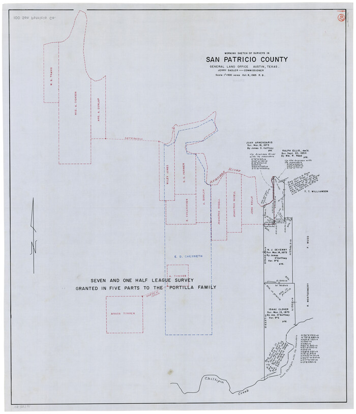
Print $20.00
- Digital $50.00
San Patricio County Working Sketch 20
1965
Size 37.2 x 32.3 inches
Map/Doc 63782
Flight Mission No. CGI-4N, Frame 30, Cameron County

Print $20.00
- Digital $50.00
Flight Mission No. CGI-4N, Frame 30, Cameron County
1954
Size 18.6 x 22.3 inches
Map/Doc 84663
Presidio County

Print $40.00
- Digital $50.00
Presidio County
1875
Size 98.1 x 36.4 inches
Map/Doc 88866