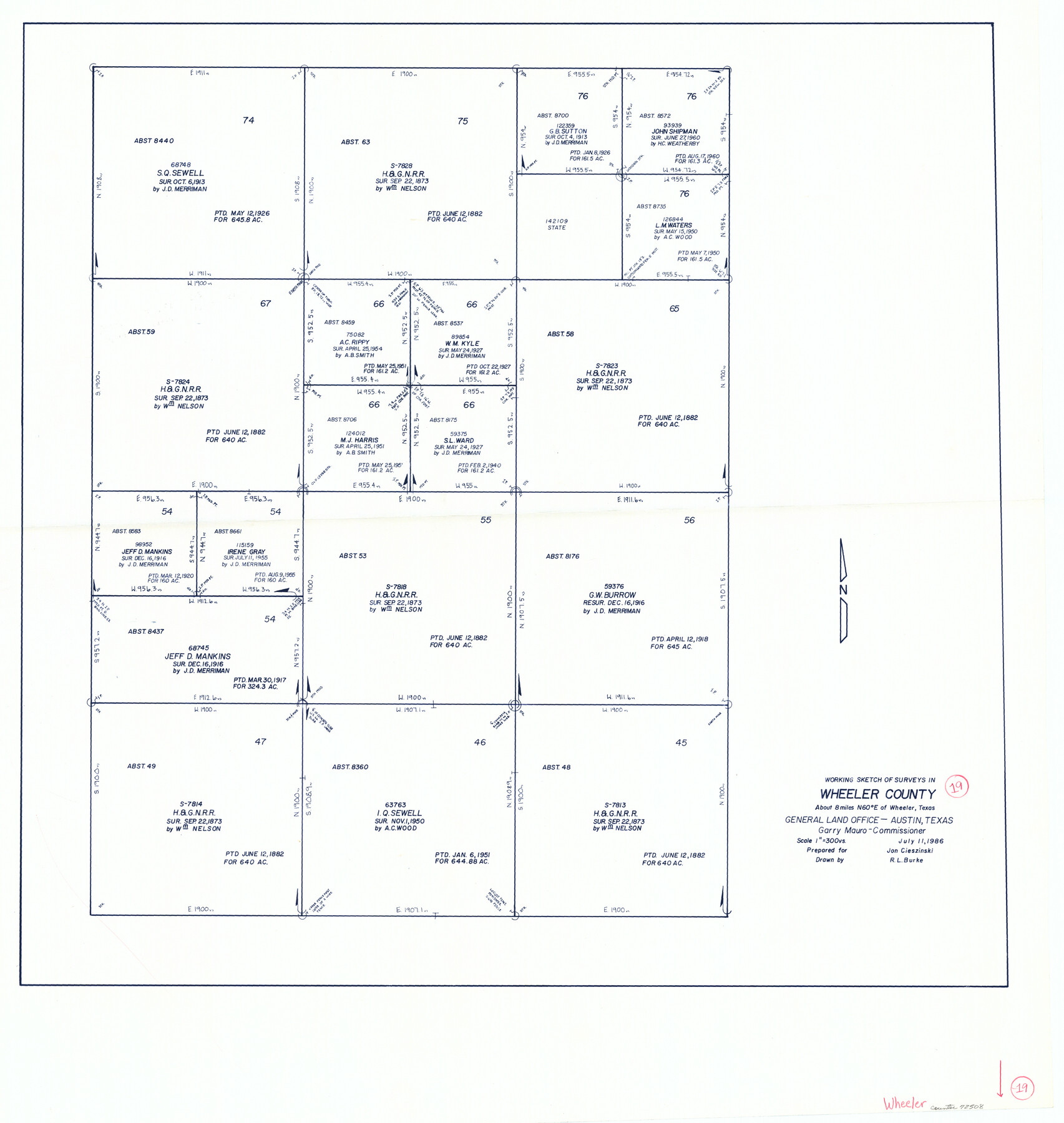
Wheeler County Working Sketch 19
-
Map/Doc
72508
-
Collection
General Map Collection
-
Object Dates
7/11/1986 (Creation Date)
-
People and Organizations
R.L. Burke (Draftsman)
-
Counties
Wheeler
-
Subjects
Surveying Working Sketch
-
Height x Width
33.5 x 31.8 inches
85.1 x 80.8 cm
-
Scale
1" = 300 varas
Part of: General Map Collection
Tyler County Working Sketch 19

Print $20.00
- Digital $50.00
Tyler County Working Sketch 19
1967
Size 47.8 x 42.9 inches
Map/Doc 69489
Duval County Working Sketch 38

Print $20.00
- Digital $50.00
Duval County Working Sketch 38
1960
Size 18.3 x 22.8 inches
Map/Doc 68762
[Nueces Bay, Mustang Island and Padre Island]
![73463, [Nueces Bay, Mustang Island and Padre Island], General Map Collection](https://historictexasmaps.com/wmedia_w700/maps/73463-1.tif.jpg)
Print $4.00
- Digital $50.00
[Nueces Bay, Mustang Island and Padre Island]
1887
Size 18.5 x 26.2 inches
Map/Doc 73463
Rusk County Sketch File 33

Print $10.00
Rusk County Sketch File 33
1949
Size 11.5 x 8.8 inches
Map/Doc 35568
Motley County Rolled Sketch 1

Print $20.00
- Digital $50.00
Motley County Rolled Sketch 1
1989
Size 39.0 x 47.6 inches
Map/Doc 9552
Starr County Working Sketch 5

Print $20.00
- Digital $50.00
Starr County Working Sketch 5
1930
Size 35.8 x 24.8 inches
Map/Doc 63921
Matagorda Light to Aransas Pass

Print $20.00
- Digital $50.00
Matagorda Light to Aransas Pass
1946
Size 35.8 x 44.5 inches
Map/Doc 73394

Nolan County Sketch File 10

Print $6.00
- Digital $50.00
Nolan County Sketch File 10
1902
Size 14.2 x 9.0 inches
Map/Doc 32484

Brewster Co[unty]
![16947, Brewster Co[unty], General Map Collection](https://historictexasmaps.com/wmedia_w700/maps/16947.tif.jpg)
Print $40.00
- Digital $50.00
Brewster Co[unty]
1904
Size 63.5 x 48.0 inches
Map/Doc 16947
Karnes County

Print $20.00
- Digital $50.00
Karnes County
1921
Size 44.3 x 39.6 inches
Map/Doc 95551
You may also like
San Patricio County Rolled Sketch 51

Print $40.00
- Digital $50.00
San Patricio County Rolled Sketch 51
1988
Size 41.8 x 54.6 inches
Map/Doc 10635
[Wilson Strickland Survey]
![91378, [Wilson Strickland Survey], Twichell Survey Records](https://historictexasmaps.com/wmedia_w700/maps/91378-1.tif.jpg)
Print $20.00
- Digital $50.00
[Wilson Strickland Survey]
Size 39.7 x 29.2 inches
Map/Doc 91378
Flight Mission No. CRC-3R, Frame 97, Chambers County

Print $20.00
- Digital $50.00
Flight Mission No. CRC-3R, Frame 97, Chambers County
1956
Size 18.5 x 22.3 inches
Map/Doc 84835
El Paso County Boundary File 11

Print $58.00
- Digital $50.00
El Paso County Boundary File 11
Size 9.3 x 6.5 inches
Map/Doc 53125

Travis County Working Sketch 59

Print $20.00
- Digital $50.00
Travis County Working Sketch 59
1992
Size 33.1 x 29.0 inches
Map/Doc 69443
[SW Corner of Yoakum County]
![92443, [SW Corner of Yoakum County], Twichell Survey Records](https://historictexasmaps.com/wmedia_w700/maps/92443-1.tif.jpg)
Print $20.00
- Digital $50.00
[SW Corner of Yoakum County]
Size 24.2 x 18.5 inches
Map/Doc 92443
Edwards County Working Sketch 43

Print $20.00
- Digital $50.00
Edwards County Working Sketch 43
1950
Size 20.3 x 27.7 inches
Map/Doc 68919
Kinney County Rolled Sketch O

Print $20.00
- Digital $50.00
Kinney County Rolled Sketch O
1848
Size 32.1 x 36.2 inches
Map/Doc 6547
Newton County Working Sketch 19

Print $20.00
- Digital $50.00
Newton County Working Sketch 19
1951
Size 28.7 x 23.4 inches
Map/Doc 71265
Presidio County Working Sketch 95

Print $40.00
- Digital $50.00
Presidio County Working Sketch 95
1976
Size 62.8 x 32.0 inches
Map/Doc 71772
