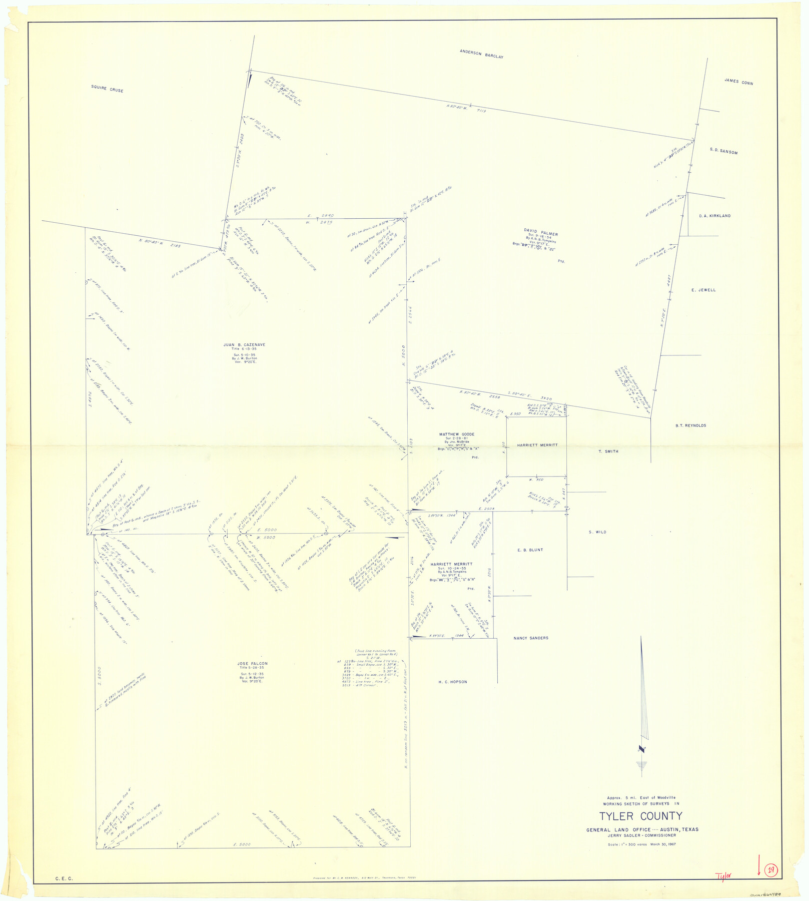
Tyler County Working Sketch 19
-
Map/Doc
69489
-
Collection
General Map Collection
-
Object Dates
3/30/1967 (Creation Date)
-
Counties
Tyler
-
Subjects
Surveying Working Sketch
-
Height x Width
47.8 x 42.9 inches
121.4 x 109.0 cm
-
Scale
1" = 300 varas
Part of: General Map Collection
Concho County Rolled Sketch 24

Print $20.00
- Digital $50.00
Concho County Rolled Sketch 24
1964
Size 27.5 x 36.9 inches
Map/Doc 5557
Grayson County Fannin District

Print $20.00
- Digital $50.00
Grayson County Fannin District
1885
Size 40.1 x 37.7 inches
Map/Doc 4961
Travis County Sketch File 5

Print $4.00
- Digital $50.00
Travis County Sketch File 5
Size 11.0 x 8.2 inches
Map/Doc 38281
Haskell County Working Sketch 16

Print $20.00
- Digital $50.00
Haskell County Working Sketch 16
1986
Size 37.9 x 47.3 inches
Map/Doc 66074
Clay County Sketch File 27

Print $20.00
- Digital $50.00
Clay County Sketch File 27
1900
Size 18.8 x 16.5 inches
Map/Doc 11089
[Surveys in the Bexar District along the San Antonio River showing the position of the missions]
![125, [Surveys in the Bexar District along the San Antonio River showing the position of the missions], General Map Collection](https://historictexasmaps.com/wmedia_w700/maps/125.tif.jpg)
Print $3.00
- Digital $50.00
[Surveys in the Bexar District along the San Antonio River showing the position of the missions]
1841
Size 11.2 x 16.0 inches
Map/Doc 125
Newton County Working Sketch 23

Print $20.00
- Digital $50.00
Newton County Working Sketch 23
1952
Size 22.0 x 26.6 inches
Map/Doc 71269
Limestone County Working Sketch 13

Print $20.00
- Digital $50.00
Limestone County Working Sketch 13
1922
Size 11.8 x 11.8 inches
Map/Doc 70563
Crockett County Sketch File 27

Print $10.00
- Digital $50.00
Crockett County Sketch File 27
1883
Size 9.1 x 14.5 inches
Map/Doc 19717
Bee County Boundary File 2

Print $10.00
- Digital $50.00
Bee County Boundary File 2
Size 8.8 x 6.8 inches
Map/Doc 50435
Central Part of Jeff Davis Co.

Print $40.00
- Digital $50.00
Central Part of Jeff Davis Co.
1982
Size 56.3 x 43.9 inches
Map/Doc 95543
Flight Mission No. DCL-6C, Frame 20, Kenedy County

Print $20.00
- Digital $50.00
Flight Mission No. DCL-6C, Frame 20, Kenedy County
1943
Size 18.7 x 22.4 inches
Map/Doc 85877
You may also like
Collin County Working Sketch 3

Print $20.00
- Digital $50.00
Collin County Working Sketch 3
1935
Size 25.8 x 41.7 inches
Map/Doc 68097
Wheeler County

Print $20.00
- Digital $50.00
Wheeler County
1932
Size 41.7 x 38.0 inches
Map/Doc 73322
[Surveys in Austin's Colony along the Navidad River; John P. Borden for Thos. H. Borden]
![77, [Surveys in Austin's Colony along the Navidad River; John P. Borden for Thos. H. Borden], General Map Collection](https://historictexasmaps.com/wmedia_w700/maps/77.tif.jpg)
Print $20.00
- Digital $50.00
[Surveys in Austin's Colony along the Navidad River; John P. Borden for Thos. H. Borden]
1831
Size 20.6 x 9.3 inches
Map/Doc 77
Go Turnpike! Dallas-Fort Worth Turnpike (Verso)

Go Turnpike! Dallas-Fort Worth Turnpike (Verso)
1963
Size 11.2 x 17.2 inches
Map/Doc 94178
Hudspeth County Sketch File 18

Print $6.00
- Digital $50.00
Hudspeth County Sketch File 18
1935
Size 11.2 x 8.7 inches
Map/Doc 26959
Brewster County Rolled Sketch 18B

Print $20.00
- Digital $50.00
Brewster County Rolled Sketch 18B
1906
Size 16.2 x 18.1 inches
Map/Doc 5197
The Peters Colony. January 20, 1843

Print $20.00
The Peters Colony. January 20, 1843
2020
Size 17.2 x 21.7 inches
Map/Doc 96365
Mills County Sketch File 4a

Print $3.00
- Digital $50.00
Mills County Sketch File 4a
1874
Size 14.5 x 10.1 inches
Map/Doc 31651
Township 3 South Range 12 West, South Western District, Louisiana

Print $20.00
- Digital $50.00
Township 3 South Range 12 West, South Western District, Louisiana
1879
Size 19.5 x 24.8 inches
Map/Doc 65883
Cooke County Sketch File 9a

Print $4.00
- Digital $50.00
Cooke County Sketch File 9a
Size 8.2 x 9.4 inches
Map/Doc 19240
Flight Mission No. CGI-1N, Frame 216, Cameron County

Print $20.00
- Digital $50.00
Flight Mission No. CGI-1N, Frame 216, Cameron County
1955
Size 18.5 x 22.2 inches
Map/Doc 84525
Sterling County Sketch File A

Print $20.00
- Digital $50.00
Sterling County Sketch File A
1906
Size 18.2 x 26.0 inches
Map/Doc 12362