Brewster County Rolled Sketch 18B
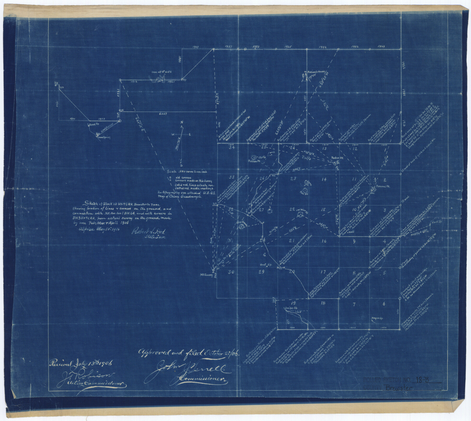
Sketch of Block 10, H. & T. C. R.R., Brewster Co., Texas, showing location of lines & corners on the ground and connection with NE cor. sur. 1, Blk G4, and with corners in Blk 9, H. & T. C. R.R. from actual survey on the ground
-
Map/Doc
5197
-
Collection
General Map Collection
-
Object Dates
1906/10/25 (File Date)
1906/5/10 (Creation Date)
-
People and Organizations
Robert S. Dod (Surveyor/Engineer)
-
Counties
Brewster
-
Subjects
Surveying Rolled Sketch
-
Height x Width
16.2 x 18.1 inches
41.1 x 46.0 cm
-
Medium
blueprint/diazo
-
Scale
1" = 1600 varas
-
Comments
See Brewster County Rolled Sketch 125 (43141) for surveyor’s report.
Related maps
Brewster County Rolled Sketch 125

Print $179.00
- Digital $50.00
Brewster County Rolled Sketch 125
1889
Map/Doc 43141
Part of: General Map Collection
Map of Houston & Overton Branch Railroad

Print $40.00
- Digital $50.00
Map of Houston & Overton Branch Railroad
1877
Size 22.3 x 110.1 inches
Map/Doc 64460
Pecos County Rolled Sketch 150

Print $20.00
- Digital $50.00
Pecos County Rolled Sketch 150
1958
Size 27.6 x 24.7 inches
Map/Doc 7280
Map of Hale and Floyd, Lubbock and Crosby Counties

Print $40.00
- Digital $50.00
Map of Hale and Floyd, Lubbock and Crosby Counties
1892
Size 53.0 x 41.3 inches
Map/Doc 2919
San Jacinto River and Tributaries, Texas - Survey of 1939

Print $20.00
- Digital $50.00
San Jacinto River and Tributaries, Texas - Survey of 1939
1939
Size 27.8 x 40.7 inches
Map/Doc 60308
Presidio County Sketch File 105

Print $20.00
- Digital $50.00
Presidio County Sketch File 105
Size 15.6 x 42.6 inches
Map/Doc 11726
Schleicher County Working Sketch 19

Print $20.00
- Digital $50.00
Schleicher County Working Sketch 19
1948
Size 43.5 x 38.9 inches
Map/Doc 63821
Navarro County Sketch File 17

Print $4.00
- Digital $50.00
Navarro County Sketch File 17
Size 12.8 x 8.4 inches
Map/Doc 32333
Culberson County Rolled Sketch 39

Print $20.00
- Digital $50.00
Culberson County Rolled Sketch 39
Size 20.5 x 28.7 inches
Map/Doc 78465
Tom Green County Sketch File 88

Print $8.00
- Digital $50.00
Tom Green County Sketch File 88
1990
Size 11.5 x 8.9 inches
Map/Doc 38266
Presidio County Rolled Sketch 3A

Print $20.00
- Digital $50.00
Presidio County Rolled Sketch 3A
Size 18.5 x 16.8 inches
Map/Doc 7327
Guadalupe County Working Sketch 10

Print $20.00
- Digital $50.00
Guadalupe County Working Sketch 10
1966
Size 21.2 x 27.2 inches
Map/Doc 63319
Newton County Rolled Sketch 12

Print $40.00
- Digital $50.00
Newton County Rolled Sketch 12
1952
Size 38.4 x 56.1 inches
Map/Doc 9577
You may also like
Upton County Rolled Sketch 35

Print $20.00
- Digital $50.00
Upton County Rolled Sketch 35
1951
Size 37.3 x 19.2 inches
Map/Doc 8077
Runnels County Rolled Sketch 48

Print $20.00
- Digital $50.00
Runnels County Rolled Sketch 48
Size 32.4 x 36.7 inches
Map/Doc 7533
Sketch of part of the NW part, Hutchinson County

Print $20.00
- Digital $50.00
Sketch of part of the NW part, Hutchinson County
1909
Size 20.9 x 31.2 inches
Map/Doc 75816
Red River County Sketch File 8

Print $22.00
- Digital $50.00
Red River County Sketch File 8
Size 14.7 x 16.8 inches
Map/Doc 35112
Val Verde County Rolled Sketch 74

Print $20.00
- Digital $50.00
Val Verde County Rolled Sketch 74
Size 18.9 x 19.5 inches
Map/Doc 8137
Crosby County Sketch File B

Print $20.00
- Digital $50.00
Crosby County Sketch File B
1877
Size 21.9 x 21.0 inches
Map/Doc 11259
General Highway Map Lynn County

Print $20.00
- Digital $50.00
General Highway Map Lynn County
1949
Size 25.8 x 18.8 inches
Map/Doc 92901
Real County Rolled Sketch 18

Print $20.00
- Digital $50.00
Real County Rolled Sketch 18
Size 22.0 x 28.0 inches
Map/Doc 7464
Il Cuscho Citta Principale Della Provincia del Peru

Print $20.00
- Digital $50.00
Il Cuscho Citta Principale Della Provincia del Peru
1592
Size 12.3 x 15.4 inches
Map/Doc 97026

Kerr County Working Sketch 23

Print $20.00
- Digital $50.00
Kerr County Working Sketch 23
1966
Size 33.4 x 41.0 inches
Map/Doc 70054
Railroad Track Map, H&TCRRCo., Falls County, Texas

Print $4.00
- Digital $50.00
Railroad Track Map, H&TCRRCo., Falls County, Texas
1918
Size 11.8 x 18.5 inches
Map/Doc 62837