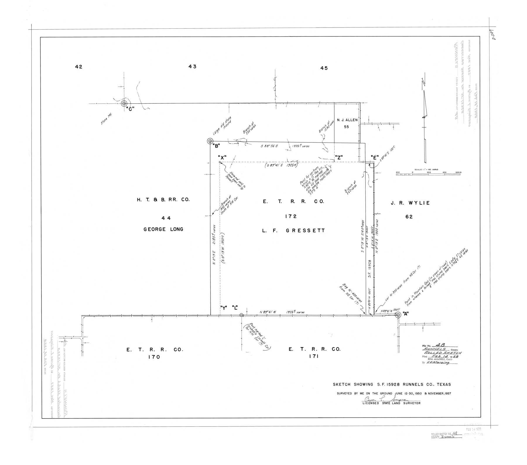
Runnels County Rolled Sketch 48
Sketch showing SF-15928, Runnels Co., Texas
-
Map/Doc
7533
-
Collection
General Map Collection
-
Object Dates
1957 (Survey Date)
1958/2/14 (File Date)
-
People and Organizations
Byron L. Simpson (Surveyor/Engineer)
-
Counties
Runnels
-
Subjects
Surveying Rolled Sketch
-
Height x Width
32.4 x 36.7 inches
82.3 x 93.2 cm
-
Scale
1" = 180 varas
Part of: General Map Collection
Tom Green County Working Sketch 1

Print $3.00
- Digital $50.00
Tom Green County Working Sketch 1
1915
Size 11.0 x 13.8 inches
Map/Doc 69370
Jasper County Sketch File 21

Print $4.00
- Digital $50.00
Jasper County Sketch File 21
Size 13.4 x 8.9 inches
Map/Doc 27820


[Sketches in McMullen County, San Patricio District]
![69747, [Sketches in McMullen County, San Patricio District], General Map Collection](https://historictexasmaps.com/wmedia_w700/maps/69747.tif.jpg)
Print $2.00
- Digital $50.00
[Sketches in McMullen County, San Patricio District]
1842
Size 10.5 x 8.0 inches
Map/Doc 69747
Newton County Sketch File 4c

Print $4.00
- Digital $50.00
Newton County Sketch File 4c
Size 7.4 x 8.2 inches
Map/Doc 32366
Right of Way and Track Map, International & Gt. Northern Ry. operated by the International & Gt. Northern Ry. Co. Gulf Division, Mineola Branch

Print $40.00
- Digital $50.00
Right of Way and Track Map, International & Gt. Northern Ry. operated by the International & Gt. Northern Ry. Co. Gulf Division, Mineola Branch
1917
Size 25.2 x 120.8 inches
Map/Doc 64703
Cameron County Sketch File 4

Print $52.00
- Digital $50.00
Cameron County Sketch File 4
1968
Size 11.3 x 8.8 inches
Map/Doc 17024
San Patricio County Rolled Sketch 46F

Print $4.00
- Digital $50.00
San Patricio County Rolled Sketch 46F
1983
Size 18.0 x 23.1 inches
Map/Doc 8377
Hansford County

Print $20.00
- Digital $50.00
Hansford County
1889
Size 22.7 x 18.9 inches
Map/Doc 4558
Medina County

Print $40.00
- Digital $50.00
Medina County
1976
Size 53.5 x 44.2 inches
Map/Doc 95587
[Map of the River Sabine from its mouth on the Gulf of Mexico in the sea to Logan's Ferry in Latitude 31° 58' 24" North]
![94005, [Map of the River Sabine from its mouth on the Gulf of Mexico in the sea to Logan's Ferry in Latitude 31° 58' 24" North], General Map Collection](https://historictexasmaps.com/wmedia_w700/maps/94005.tif.jpg)
Print $20.00
- Digital $50.00
[Map of the River Sabine from its mouth on the Gulf of Mexico in the sea to Logan's Ferry in Latitude 31° 58' 24" North]
Size 31.5 x 31.3 inches
Map/Doc 94005
You may also like
Flight Mission No. CUG-1P, Frame 26, Kleberg County

Print $20.00
- Digital $50.00
Flight Mission No. CUG-1P, Frame 26, Kleberg County
1956
Size 18.6 x 22.2 inches
Map/Doc 86116
T. & N. O. R.R. Jefferson Co. North

Print $20.00
- Digital $50.00
T. & N. O. R.R. Jefferson Co. North
1917
Size 13.5 x 33.2 inches
Map/Doc 64057
Uvalde County Working Sketch 38

Print $20.00
- Digital $50.00
Uvalde County Working Sketch 38
1970
Size 33.3 x 30.8 inches
Map/Doc 72108
Crane County Working Sketch 7

Print $20.00
- Digital $50.00
Crane County Working Sketch 7
1929
Size 33.6 x 23.2 inches
Map/Doc 68284
Webb County Boundary File 6

Print $123.00
- Digital $50.00
Webb County Boundary File 6
Size 14.4 x 8.8 inches
Map/Doc 59786
Concho County Sketch File 43

Print $6.00
- Digital $50.00
Concho County Sketch File 43
1948
Size 14.4 x 8.9 inches
Map/Doc 19204
Corpus Christi, Where Texas Meets the Sea

Corpus Christi, Where Texas Meets the Sea
1928
Size 9.7 x 6.9 inches
Map/Doc 97065
[Sketch of part of G. & M. Block 5]
![93077, [Sketch of part of G. & M. Block 5], Twichell Survey Records](https://historictexasmaps.com/wmedia_w700/maps/93077-1.tif.jpg)
Print $3.00
- Digital $50.00
[Sketch of part of G. & M. Block 5]
Size 17.7 x 9.4 inches
Map/Doc 93077
Hamilton County Sketch File A

Print $4.00
- Digital $50.00
Hamilton County Sketch File A
1879
Size 9.1 x 8.2 inches
Map/Doc 24948
Outer Continental Shelf Leasing Maps (Louisiana Offshore Operations)

Print $20.00
- Digital $50.00
Outer Continental Shelf Leasing Maps (Louisiana Offshore Operations)
1954
Size 22.2 x 12.0 inches
Map/Doc 76096
Calhoun County Rolled Sketch 14

Print $20.00
- Digital $50.00
Calhoun County Rolled Sketch 14
Size 21.5 x 40.2 inches
Map/Doc 5461
[Plat of Texas and Pacific Railroad Company Block Lines, 80 Mile Reserve]
![3124, [Plat of Texas and Pacific Railroad Company Block Lines, 80 Mile Reserve], General Map Collection](https://historictexasmaps.com/wmedia_w700/maps/3124-1.tif.jpg)
Print $40.00
- Digital $50.00
[Plat of Texas and Pacific Railroad Company Block Lines, 80 Mile Reserve]
1876
Size 43.5 x 46.3 inches
Map/Doc 3124