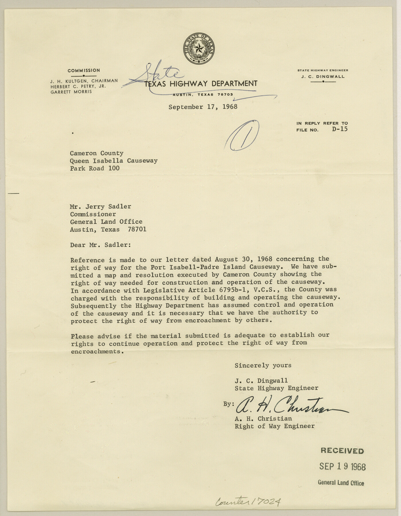
Cameron County Sketch File 4
[Map and correspondence between GLO and State Highway Department concerning a right of way for the Port Isabell-Padre Island Causeway]
-
Map/Doc
17024
-
Collection
General Map Collection
-
Object Dates
1968/9/19 (File Date)
1968/9/17 (Creation Date)
-
People and Organizations
A.H. Christian (Surveyor/Engineer)
J.C. Dingwall (Surveyor/Engineer)
Jerry Sadler (GLO Commissioner)
-
Counties
Cameron
-
Subjects
Surveying Sketch File
-
Height x Width
11.3 x 8.8 inches
28.7 x 22.4 cm
-
Medium
multi-page, multi-format
-
Features
Port Isabell-Padre Island Causeway
Port Isabell Causeway
Padre Island Causeway
State Highway 4
State Highway 100
Port Isabel Bridge
Laguna Madre Bridge
Padre Island
Port Isabel
Long Island
Garcia Street
Monroe Street
South Shore Drive
Tarnava Street
Part of: General Map Collection
McCulloch County Working Sketch 13

Print $20.00
- Digital $50.00
McCulloch County Working Sketch 13
1989
Size 36.7 x 33.3 inches
Map/Doc 70688
Hood County Working Sketch 22

Print $20.00
- Digital $50.00
Hood County Working Sketch 22
1991
Size 17.9 x 27.1 inches
Map/Doc 66216
Gulf of Mexico

Print $20.00
- Digital $50.00
Gulf of Mexico
1900
Size 18.2 x 28.1 inches
Map/Doc 72647
Nacogdoches County Working Sketch 2

Print $20.00
- Digital $50.00
Nacogdoches County Working Sketch 2
1904
Size 20.5 x 24.1 inches
Map/Doc 71218
Floyd County Working Sketch 5

Print $20.00
- Digital $50.00
Floyd County Working Sketch 5
1955
Size 33.3 x 23.6 inches
Map/Doc 69184
The Coast of Texas

Print $20.00
- Digital $50.00
The Coast of Texas
1844
Size 18.3 x 27.1 inches
Map/Doc 72699
Kaufman County Sketch File 3

Print $20.00
- Digital $50.00
Kaufman County Sketch File 3
1857
Size 25.3 x 18.7 inches
Map/Doc 4856
[Map of Hidalgo County]
![6207, [Map of Hidalgo County], General Map Collection](https://historictexasmaps.com/wmedia_w700/maps/6207.tif.jpg)
Print $20.00
- Digital $50.00
[Map of Hidalgo County]
1882
Size 26.0 x 19.9 inches
Map/Doc 6207
Callahan County Working Sketch 2

Print $20.00
- Digital $50.00
Callahan County Working Sketch 2
1952
Size 29.1 x 35.4 inches
Map/Doc 67884
Jasper County Working Sketch Graphic Index

Print $20.00
- Digital $50.00
Jasper County Working Sketch Graphic Index
1946
Size 47.9 x 41.0 inches
Map/Doc 76591
Erath County Working Sketch 42

Print $20.00
- Digital $50.00
Erath County Working Sketch 42
1981
Size 23.0 x 23.6 inches
Map/Doc 69123
[Atchison, Topeka & Santa Fe from Paisano to south of Plata]
![64710, [Atchison, Topeka & Santa Fe from Paisano to south of Plata], General Map Collection](https://historictexasmaps.com/wmedia_w700/maps/64710.tif.jpg)
Print $40.00
- Digital $50.00
[Atchison, Topeka & Santa Fe from Paisano to south of Plata]
Size 34.2 x 121.7 inches
Map/Doc 64710
You may also like
Military Reconnaissance [showing forts along Rio Grande near Matamoros]
![72910, Military Reconnaissance [showing forts along Rio Grande near Matamoros], General Map Collection](https://historictexasmaps.com/wmedia_w700/maps/72910.tif.jpg)
Print $20.00
- Digital $50.00
Military Reconnaissance [showing forts along Rio Grande near Matamoros]
1846
Size 18.4 x 26.7 inches
Map/Doc 72910
Potter County Boundary File 4b

Print $20.00
- Digital $50.00
Potter County Boundary File 4b
Size 9.2 x 32.9 inches
Map/Doc 58012
Flight Mission No. BQR-9K, Frame 11, Brazoria County

Print $20.00
- Digital $50.00
Flight Mission No. BQR-9K, Frame 11, Brazoria County
1952
Size 18.7 x 22.4 inches
Map/Doc 84040
Llano County Working Sketch 10

Print $20.00
- Digital $50.00
Llano County Working Sketch 10
1980
Size 21.2 x 15.1 inches
Map/Doc 70628
Map showing the fortification at Point Isabel

Print $20.00
- Digital $50.00
Map showing the fortification at Point Isabel
1864
Size 18.3 x 27.9 inches
Map/Doc 72921
Flight Mission No. DQN-2K, Frame 95, Calhoun County

Print $20.00
- Digital $50.00
Flight Mission No. DQN-2K, Frame 95, Calhoun County
1953
Size 18.6 x 22.3 inches
Map/Doc 84285
Webb County Sketch File 44a

Print $20.00
- Digital $50.00
Webb County Sketch File 44a
1936
Size 29.4 x 18.2 inches
Map/Doc 12640
Johnson County Rolled Sketch 2

Print $20.00
- Digital $50.00
Johnson County Rolled Sketch 2
1956
Size 20.6 x 22.3 inches
Map/Doc 6447
Presidio County Sketch File 91

Print $40.00
- Digital $50.00
Presidio County Sketch File 91
Size 12.3 x 15.9 inches
Map/Doc 34763
[Center line of Blk. 36, T1N]
![89822, [Center line of Blk. 36, T1N], Twichell Survey Records](https://historictexasmaps.com/wmedia_w700/maps/89822-1.tif.jpg)
Print $40.00
- Digital $50.00
[Center line of Blk. 36, T1N]
1907
Size 12.6 x 69.7 inches
Map/Doc 89822
Ward County Rolled Sketch 13

Print $20.00
- Digital $50.00
Ward County Rolled Sketch 13
1938
Size 30.0 x 20.0 inches
Map/Doc 8156
Loving County, Texas

Print $20.00
- Digital $50.00
Loving County, Texas
1889
Size 18.8 x 23.8 inches
Map/Doc 638