[Surveying Sketch of M. Farley, R. Word, S. S. Hervey, et al in Kleberg County, Texas]
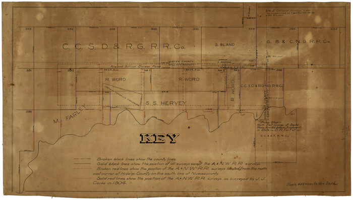
Print $20.00
- Digital $50.00
[Surveying Sketch of M. Farley, R. Word, S. S. Hervey, et al in Kleberg County, Texas]
Size: 23.2 x 40.6 inches
10783
Cameron County Rolled Sketch 11

Print $20.00
- Digital $50.00
Cameron County Rolled Sketch 11
Size: 26.7 x 34.0 inches
11047
Cameron County Rolled Sketch 11A

Print $20.00
- Digital $50.00
Cameron County Rolled Sketch 11A
1934
Size: 30.0 x 37.0 inches
11048
Hidalgo County Sketch File 10

Print $20.00
- Digital $50.00
Hidalgo County Sketch File 10
1911
Size: 16.3 x 34.8 inches
11762
[Sketch with field note calls of the boundaries of Webb, Duval, Jim Wells,Nueces, Kleberg, Zapata, Jim Hogg, Brooks, Willacy, Starr, Hidalgo and Cameron Counties]
![1689, [Sketch with field note calls of the boundaries of Webb, Duval, Jim Wells,Nueces, Kleberg, Zapata, Jim Hogg, Brooks, Willacy, Starr, Hidalgo and Cameron Counties], General Map Collection](https://historictexasmaps.com/wmedia_w700/pdf_converted_jpg/qi_pdf_thumbnail_720.jpg)
Print $20.00
- Digital $50.00
[Sketch with field note calls of the boundaries of Webb, Duval, Jim Wells,Nueces, Kleberg, Zapata, Jim Hogg, Brooks, Willacy, Starr, Hidalgo and Cameron Counties]
1915
Size: 21.9 x 26.2 inches
1689
Cameron County Sketch File 2

Print $98.00
- Digital $50.00
Cameron County Sketch File 2
1904
Size: 14.3 x 8.7 inches
16975
Cameron County Sketch File 3

Print $42.00
- Digital $50.00
Cameron County Sketch File 3
1930
Size: 11.1 x 8.8 inches
17023
Cameron County Sketch File 4

Print $52.00
- Digital $50.00
Cameron County Sketch File 4
1968
Size: 11.3 x 8.8 inches
17024
Cameron County Sketch File 5

Print $4.00
- Digital $50.00
Cameron County Sketch File 5
1978
Size: 11.1 x 8.7 inches
17030
Cameron County Sketch File 6

Print $20.00
- Digital $50.00
Cameron County Sketch File 6
1970
Size: 11.0 x 8.5 inches
17032
Cameron County Sketch File 7

Print $146.00
- Digital $50.00
Cameron County Sketch File 7
1980
Size: 14.3 x 8.7 inches
17042
Cameron County Sketch File 8

Print $73.00
- Digital $50.00
Cameron County Sketch File 8
1982
Size: 11.4 x 8.9 inches
17124
Cameron County Sketch File 8b

Print $145.00
- Digital $50.00
Cameron County Sketch File 8b
Size: 14.0 x 8.5 inches
17137
Cameron County Sketch File 9

Print $26.00
- Digital $50.00
Cameron County Sketch File 9
1983
Size: 11.2 x 8.3 inches
17197
Cameron County Sketch File 10

Print $8.00
- Digital $50.00
Cameron County Sketch File 10
1989
Size: 11.1 x 8.6 inches
17205
Cameron County Sketch File 11

Print $58.00
- Digital $50.00
Cameron County Sketch File 11
1991
Size: 11.0 x 7.9 inches
17207
Cameron County Sketch File 12

Print $222.00
- Digital $50.00
Cameron County Sketch File 12
Size: 10.8 x 7.4 inches
17236
Cameron County Sketch File 13

Print $50.00
- Digital $50.00
Cameron County Sketch File 13
Size: 11.0 x 8.5 inches
17298
Cameron County Sketch File 14

Print $38.00
- Digital $50.00
Cameron County Sketch File 14
1993
Size: 11.2 x 8.8 inches
17311
Cameron County Sketch File 15

Print $26.00
- Digital $50.00
Cameron County Sketch File 15
1999
Size: 11.2 x 8.7 inches
17320
Part of Laguna Madre in Willacy and Cameron Counties, showing Subdivision for Mineral Development

Print $20.00
- Digital $50.00
Part of Laguna Madre in Willacy and Cameron Counties, showing Subdivision for Mineral Development
1950
Size: 45.1 x 36.8 inches
1925
Part of Laguna Madre in Cameron County, showing Subdivision for Mineral Development

Print $20.00
- Digital $50.00
Part of Laguna Madre in Cameron County, showing Subdivision for Mineral Development
1963
Size: 45.8 x 36.0 inches
1926
Part of Laguna Madre in Cameron County, showing Subdivision for Mineral Development

Print $20.00
- Digital $50.00
Part of Laguna Madre in Cameron County, showing Subdivision for Mineral Development
1953
Size: 33.0 x 21.9 inches
1927
Texas Gulf Coast, from the Sabine River to the Rio Grande as Subdivided for Mineral Development; Aransas, Nueces, Kleberg, Kenedy, Willacy, and Cameron Counties

Print $40.00
- Digital $50.00
Texas Gulf Coast, from the Sabine River to the Rio Grande as Subdivided for Mineral Development; Aransas, Nueces, Kleberg, Kenedy, Willacy, and Cameron Counties
1976
Size: 118.0 x 43.0 inches
1940
Rio Grande from San Juan River to the Gulf of Mexico showing Boundary between the United States and Mexico

Print $20.00
- Digital $50.00
Rio Grande from San Juan River to the Gulf of Mexico showing Boundary between the United States and Mexico
1903
Size: 25.6 x 15.8 inches
2065
Map of section no. 10 of a survey of Padre Island made for the Office of the Attorney General of the State of Texas

Print $40.00
- Digital $50.00
Map of section no. 10 of a survey of Padre Island made for the Office of the Attorney General of the State of Texas
1941
Size: 57.2 x 40.6 inches
2266
Map of section no. 11 of a survey of Padre Island made for the Office of the Attorney General of the State of Texas

Print $40.00
- Digital $50.00
Map of section no. 11 of a survey of Padre Island made for the Office of the Attorney General of the State of Texas
1941
Size: 60.1 x 40.4 inches
2267
Map of section no. 12 of a survey of Padre Island made for the Office of the Attorney General of the State of Texas

Print $40.00
- Digital $50.00
Map of section no. 12 of a survey of Padre Island made for the Office of the Attorney General of the State of Texas
1941
Size: 75.9 x 41.0 inches
2268
Hidalgo County Sketch File 9

Print $40.00
- Digital $50.00
Hidalgo County Sketch File 9
1904
Size: 8.8 x 5.7 inches
26409
[Surveying Sketch of M. Farley, R. Word, S. S. Hervey, et al in Kleberg County, Texas]
Print $20.00
- Digital $50.00
[Surveying Sketch of M. Farley, R. Word, S. S. Hervey, et al in Kleberg County, Texas]
-
Size
23.2 x 40.6 inches
-
Map/Doc
10783
Cameron County Rolled Sketch 11
Print $20.00
- Digital $50.00
Cameron County Rolled Sketch 11
-
Size
26.7 x 34.0 inches
-
Map/Doc
11047
Cameron County Rolled Sketch 11A
Print $20.00
- Digital $50.00
Cameron County Rolled Sketch 11A
1934
-
Size
30.0 x 37.0 inches
-
Map/Doc
11048
-
Creation Date
1934
Hidalgo County Sketch File 10
Print $20.00
- Digital $50.00
Hidalgo County Sketch File 10
1911
-
Size
16.3 x 34.8 inches
-
Map/Doc
11762
-
Creation Date
1911
[Sketch with field note calls of the boundaries of Webb, Duval, Jim Wells,Nueces, Kleberg, Zapata, Jim Hogg, Brooks, Willacy, Starr, Hidalgo and Cameron Counties]
Print $20.00
- Digital $50.00
[Sketch with field note calls of the boundaries of Webb, Duval, Jim Wells,Nueces, Kleberg, Zapata, Jim Hogg, Brooks, Willacy, Starr, Hidalgo and Cameron Counties]
1915
-
Size
21.9 x 26.2 inches
-
Map/Doc
1689
-
Creation Date
1915
Cameron County Sketch File 2
Print $98.00
- Digital $50.00
Cameron County Sketch File 2
1904
-
Size
14.3 x 8.7 inches
-
Map/Doc
16975
-
Creation Date
1904
Cameron County Sketch File 3
Print $42.00
- Digital $50.00
Cameron County Sketch File 3
1930
-
Size
11.1 x 8.8 inches
-
Map/Doc
17023
-
Creation Date
1930
Cameron County Sketch File 4
Print $52.00
- Digital $50.00
Cameron County Sketch File 4
1968
-
Size
11.3 x 8.8 inches
-
Map/Doc
17024
-
Creation Date
1968
Cameron County Sketch File 5
Print $4.00
- Digital $50.00
Cameron County Sketch File 5
1978
-
Size
11.1 x 8.7 inches
-
Map/Doc
17030
-
Creation Date
1978
Cameron County Sketch File 6
Print $20.00
- Digital $50.00
Cameron County Sketch File 6
1970
-
Size
11.0 x 8.5 inches
-
Map/Doc
17032
-
Creation Date
1970
Cameron County Sketch File 7
Print $146.00
- Digital $50.00
Cameron County Sketch File 7
1980
-
Size
14.3 x 8.7 inches
-
Map/Doc
17042
-
Creation Date
1980
Cameron County Sketch File 8
Print $73.00
- Digital $50.00
Cameron County Sketch File 8
1982
-
Size
11.4 x 8.9 inches
-
Map/Doc
17124
-
Creation Date
1982
Cameron County Sketch File 8b
Print $145.00
- Digital $50.00
Cameron County Sketch File 8b
-
Size
14.0 x 8.5 inches
-
Map/Doc
17137
Cameron County Sketch File 9
Print $26.00
- Digital $50.00
Cameron County Sketch File 9
1983
-
Size
11.2 x 8.3 inches
-
Map/Doc
17197
-
Creation Date
1983
Cameron County Sketch File 10
Print $8.00
- Digital $50.00
Cameron County Sketch File 10
1989
-
Size
11.1 x 8.6 inches
-
Map/Doc
17205
-
Creation Date
1989
Cameron County Sketch File 11
Print $58.00
- Digital $50.00
Cameron County Sketch File 11
1991
-
Size
11.0 x 7.9 inches
-
Map/Doc
17207
-
Creation Date
1991
Cameron County Sketch File 12
Print $222.00
- Digital $50.00
Cameron County Sketch File 12
-
Size
10.8 x 7.4 inches
-
Map/Doc
17236
Cameron County Sketch File 13
Print $50.00
- Digital $50.00
Cameron County Sketch File 13
-
Size
11.0 x 8.5 inches
-
Map/Doc
17298
Cameron County Sketch File 14
Print $38.00
- Digital $50.00
Cameron County Sketch File 14
1993
-
Size
11.2 x 8.8 inches
-
Map/Doc
17311
-
Creation Date
1993
Cameron County Sketch File 15
Print $26.00
- Digital $50.00
Cameron County Sketch File 15
1999
-
Size
11.2 x 8.7 inches
-
Map/Doc
17320
-
Creation Date
1999
Cameron County

Print $20.00
- Digital $50.00
Cameron County
1913
-
Size
30.0 x 33.8 inches
-
Map/Doc
1793
-
Creation Date
1913
Part of Laguna Madre in Willacy and Cameron Counties, showing Subdivision for Mineral Development
Print $20.00
- Digital $50.00
Part of Laguna Madre in Willacy and Cameron Counties, showing Subdivision for Mineral Development
1950
-
Size
45.1 x 36.8 inches
-
Map/Doc
1925
-
Creation Date
1950
Part of Laguna Madre in Cameron County, showing Subdivision for Mineral Development
Print $20.00
- Digital $50.00
Part of Laguna Madre in Cameron County, showing Subdivision for Mineral Development
1963
-
Size
45.8 x 36.0 inches
-
Map/Doc
1926
-
Creation Date
1963
Part of Laguna Madre in Cameron County, showing Subdivision for Mineral Development
Print $20.00
- Digital $50.00
Part of Laguna Madre in Cameron County, showing Subdivision for Mineral Development
1953
-
Size
33.0 x 21.9 inches
-
Map/Doc
1927
-
Creation Date
1953
Texas Gulf Coast, from the Sabine River to the Rio Grande as Subdivided for Mineral Development; Aransas, Nueces, Kleberg, Kenedy, Willacy, and Cameron Counties
Print $40.00
- Digital $50.00
Texas Gulf Coast, from the Sabine River to the Rio Grande as Subdivided for Mineral Development; Aransas, Nueces, Kleberg, Kenedy, Willacy, and Cameron Counties
1976
-
Size
118.0 x 43.0 inches
-
Map/Doc
1940
-
Creation Date
1976
Rio Grande from San Juan River to the Gulf of Mexico showing Boundary between the United States and Mexico
Print $20.00
- Digital $50.00
Rio Grande from San Juan River to the Gulf of Mexico showing Boundary between the United States and Mexico
1903
-
Size
25.6 x 15.8 inches
-
Map/Doc
2065
-
Creation Date
1903
Map of section no. 10 of a survey of Padre Island made for the Office of the Attorney General of the State of Texas
Print $40.00
- Digital $50.00
Map of section no. 10 of a survey of Padre Island made for the Office of the Attorney General of the State of Texas
1941
-
Size
57.2 x 40.6 inches
-
Map/Doc
2266
-
Creation Date
1941
Map of section no. 11 of a survey of Padre Island made for the Office of the Attorney General of the State of Texas
Print $40.00
- Digital $50.00
Map of section no. 11 of a survey of Padre Island made for the Office of the Attorney General of the State of Texas
1941
-
Size
60.1 x 40.4 inches
-
Map/Doc
2267
-
Creation Date
1941
Map of section no. 12 of a survey of Padre Island made for the Office of the Attorney General of the State of Texas
Print $40.00
- Digital $50.00
Map of section no. 12 of a survey of Padre Island made for the Office of the Attorney General of the State of Texas
1941
-
Size
75.9 x 41.0 inches
-
Map/Doc
2268
-
Creation Date
1941
Hidalgo County Sketch File 9
Print $40.00
- Digital $50.00
Hidalgo County Sketch File 9
1904
-
Size
8.8 x 5.7 inches
-
Map/Doc
26409
-
Creation Date
1904