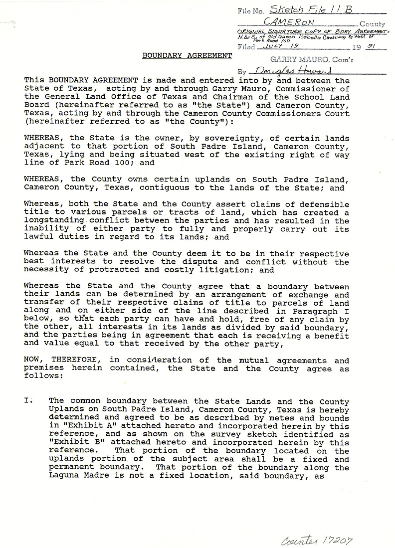
Cameron County Sketch File 11
[Boundary agreement between Cameron County and State of Texas regarding land north and south of the Old Queen Isabella Causeway and west of Park Road 100]
-
Map/Doc
17207
-
Collection
General Map Collection
-
Object Dates
1991/7/5 (Creation Date)
1991/7/19 (File Date)
-
People and Organizations
Garry Mauro (GLO Commissioner)
Elisandro Leos (Surveyor/Engineer)
-
Counties
Cameron
-
Subjects
Surveying Sketch File
-
Height x Width
11.0 x 7.9 inches
27.9 x 20.1 cm
-
Medium
paper, print
-
Comments
See Cameron County Rolled Sketch 28b (8577).
-
Features
South Padre Island
Park Road 100
Queen Isabella Causeway
Queen Isabella Road
Isla Blanca Park
Gulf of Mexico
Laguna Madre Bay
Related maps
Cameron County Rolled Sketch 28B

Print $40.00
- Digital $50.00
Cameron County Rolled Sketch 28B
1986
Size 36.9 x 48.3 inches
Map/Doc 8577
Part of: General Map Collection
Comal County Sketch File 17

Print $2.00
- Digital $50.00
Comal County Sketch File 17
Size 8.7 x 8.9 inches
Map/Doc 19036
Bosque County Sketch File 30a

Print $8.00
- Digital $50.00
Bosque County Sketch File 30a
1854
Size 14.4 x 8.7 inches
Map/Doc 14822
Texas Official Travel Map

Digital $50.00
Texas Official Travel Map
Size 33.3 x 36.2 inches
Map/Doc 94302

Tarrant County State Real Property Sketch 1

Print $60.00
- Digital $50.00
Tarrant County State Real Property Sketch 1
2007
Size 24.5 x 35.3 inches
Map/Doc 88666
Flight Mission No. DIX-10P, Frame 71, Aransas County

Print $20.00
- Digital $50.00
Flight Mission No. DIX-10P, Frame 71, Aransas County
1956
Size 18.6 x 22.3 inches
Map/Doc 83932
Presidio County Sketch File 62

Print $10.00
- Digital $50.00
Presidio County Sketch File 62
1938
Size 11.2 x 8.8 inches
Map/Doc 34647
Dickens County Sketch File 20

Print $2.00
- Digital $50.00
Dickens County Sketch File 20
1911
Size 11.5 x 8.9 inches
Map/Doc 20984
Hutchinson County Sketch File 38

Print $40.00
- Digital $50.00
Hutchinson County Sketch File 38
1935
Size 17.6 x 14.2 inches
Map/Doc 27280
Hutchinson County Rolled Sketch 42

Print $40.00
- Digital $50.00
Hutchinson County Rolled Sketch 42
1993
Size 38.0 x 49.6 inches
Map/Doc 6308
Bee County Sketch File 27

Print $8.00
- Digital $50.00
Bee County Sketch File 27
1886
Size 14.3 x 8.8 inches
Map/Doc 14331
Current Miscellaneous File 13

Print $20.00
- Digital $50.00
Current Miscellaneous File 13
Size 16.2 x 21.6 inches
Map/Doc 73820
You may also like
Blanco County Sketch File 20

Print $4.00
- Digital $50.00
Blanco County Sketch File 20
1879
Size 8.7 x 6.9 inches
Map/Doc 14598
Northeast Part Presidio County

Print $20.00
- Digital $50.00
Northeast Part Presidio County
1973
Size 42.3 x 33.4 inches
Map/Doc 95616
Val Verde County Working Sketch 117

Print $20.00
- Digital $50.00
Val Verde County Working Sketch 117
1993
Size 20.9 x 38.2 inches
Map/Doc 82841

Kent County Sketch File 10

Print $42.00
- Digital $50.00
Kent County Sketch File 10
1924
Size 22.1 x 35.5 inches
Map/Doc 11914
Harris County Working Sketch 30

Print $20.00
- Digital $50.00
Harris County Working Sketch 30
1935
Size 25.9 x 28.0 inches
Map/Doc 65922
Flight Mission No. DQN-5K, Frame 32, Calhoun County

Print $20.00
- Digital $50.00
Flight Mission No. DQN-5K, Frame 32, Calhoun County
1953
Size 16.5 x 16.3 inches
Map/Doc 84383
Dallam County Sketch File 2

Print $260.00
- Digital $50.00
Dallam County Sketch File 2
1886
Size 29.9 x 17.4 inches
Map/Doc 11278
Cameron County Boundary File 4

Print $42.00
- Digital $50.00
Cameron County Boundary File 4
Size 10.4 x 8.2 inches
Map/Doc 51110
Presidio County Working Sketch 131

Print $40.00
- Digital $50.00
Presidio County Working Sketch 131
1989
Size 43.5 x 50.4 inches
Map/Doc 71809

