Tarrant County State Real Property Sketch 1
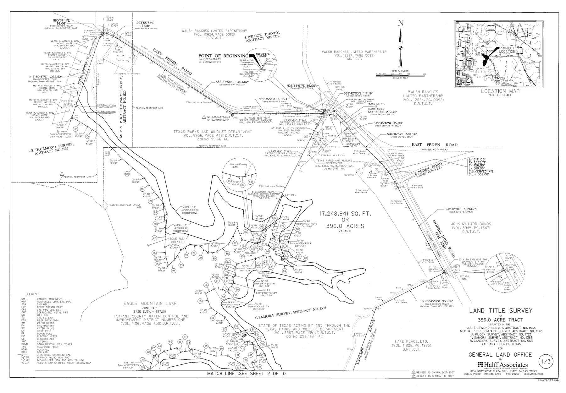
Field Notes and a Land Title Survey of 396.0 Acre Tract Situated in Survey, A - 1535, Survey, A - 1120, Survey, A - 1722, Survey, A - 1385 and Survey, A - 563
-
Map/Doc
88666
-
Collection
General Map Collection
-
Object Dates
2007/2/27 (Creation Date)
-
People and Organizations
Halff Associates (Publisher)
Halff Associates (Printer)
Gregory S. Kays (Surveyor/Engineer)
-
Counties
Tarrant
-
Subjects
State Real Property
-
Height x Width
24.5 x 35.3 inches
62.2 x 89.7 cm
-
Comments
Surveys located about 14 miles North 37 degrees West of Fort Worth, Texas.
Part of: General Map Collection
Brewster County Working Sketch Graphic Index, East Part, Sheet 1 (Sketches 1 to 111)

Print $20.00
- Digital $50.00
Brewster County Working Sketch Graphic Index, East Part, Sheet 1 (Sketches 1 to 111)
1952
Size 47.4 x 29.6 inches
Map/Doc 76476
Young County Sketch File 10

Print $20.00
- Digital $50.00
Young County Sketch File 10
Size 14.1 x 17.7 inches
Map/Doc 12711

Dimmit County Sketch File 20 1/2

Print $43.00
- Digital $50.00
Dimmit County Sketch File 20 1/2
Size 9.0 x 8.6 inches
Map/Doc 21104
Irion County Rolled Sketch 18B

Print $152.00
- Digital $50.00
Irion County Rolled Sketch 18B
1978
Size 10.6 x 15.2 inches
Map/Doc 46087
Map of Val Verde County

Print $40.00
- Digital $50.00
Map of Val Verde County
1898
Size 81.6 x 30.7 inches
Map/Doc 82013
Flight Mission No. DCL-7C, Frame 147, Kenedy County

Print $20.00
- Digital $50.00
Flight Mission No. DCL-7C, Frame 147, Kenedy County
1943
Size 18.3 x 22.4 inches
Map/Doc 86104
Brazoria County Working Sketch 50b

Print $20.00
- Digital $50.00
Brazoria County Working Sketch 50b
2003
Size 34.8 x 34.6 inches
Map/Doc 78345
Borden County Rolled Sketch 12

Print $40.00
- Digital $50.00
Borden County Rolled Sketch 12
1964
Size 48.1 x 31.6 inches
Map/Doc 8451
Eastland County

Print $20.00
- Digital $50.00
Eastland County
1945
Size 41.8 x 42.0 inches
Map/Doc 77268
Working Sketch of surveys in Brazoria County, showing Cedar Lakes

Print $40.00
- Digital $50.00
Working Sketch of surveys in Brazoria County, showing Cedar Lakes
1950
Size 31.2 x 57.3 inches
Map/Doc 1932
Map of Portion of the Gulf of Mexico Adjoining Jefferson County Showing Subdivision Thereof for Mineral Development

Print $20.00
- Digital $50.00
Map of Portion of the Gulf of Mexico Adjoining Jefferson County Showing Subdivision Thereof for Mineral Development
1940
Size 17.7 x 20.2 inches
Map/Doc 3018
You may also like
Duval County Rolled Sketch 13

Print $20.00
- Digital $50.00
Duval County Rolled Sketch 13
1937
Size 33.8 x 30.4 inches
Map/Doc 5735
Burnet County Sketch File 31

Print $4.00
- Digital $50.00
Burnet County Sketch File 31
1875
Size 12.7 x 8.1 inches
Map/Doc 16748
Denton County Sketch File 25

Print $4.00
- Digital $50.00
Denton County Sketch File 25
1863
Size 8.0 x 7.4 inches
Map/Doc 20752
Harris County Historic Topographic 4

Print $20.00
- Digital $50.00
Harris County Historic Topographic 4
1916
Size 14.5 x 24.6 inches
Map/Doc 65814
Pecos County Rolled Sketch 180

Print $20.00
- Digital $50.00
Pecos County Rolled Sketch 180
Size 33.6 x 42.0 inches
Map/Doc 9752
Southern Pacific Lines Map of Texas

Print $20.00
- Digital $50.00
Southern Pacific Lines Map of Texas
1928
Size 27.4 x 22.4 inches
Map/Doc 95774
Leon County Rolled Sketch 32

Print $20.00
- Digital $50.00
Leon County Rolled Sketch 32
Size 34.2 x 40.7 inches
Map/Doc 6616
Harris County Rolled Sketch 33

Print $20.00
- Digital $50.00
Harris County Rolled Sketch 33
1912
Size 26.0 x 34.5 inches
Map/Doc 6097
Greater Austin, Texas Streetmap

Greater Austin, Texas Streetmap
Size 45.8 x 36.2 inches
Map/Doc 94431
Cooke County Working Sketch 16

Print $20.00
- Digital $50.00
Cooke County Working Sketch 16
1949
Size 29.8 x 28.9 inches
Map/Doc 68253
Jefferson County Sketch File 52

Print $2.00
- Digital $50.00
Jefferson County Sketch File 52
1985
Size 9.1 x 14.4 inches
Map/Doc 28254
Schleicher County Sketch File 17

Print $20.00
- Digital $50.00
Schleicher County Sketch File 17
Size 23.4 x 17.8 inches
Map/Doc 12299