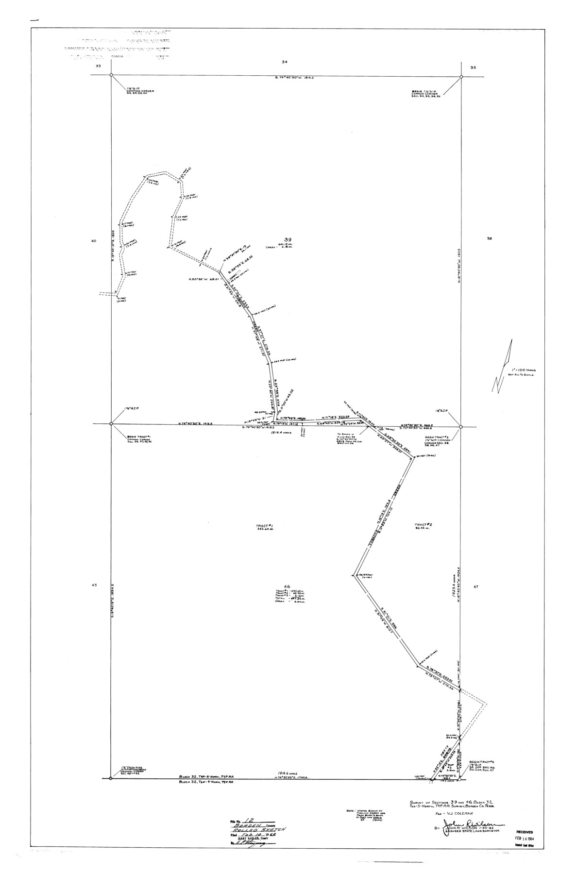
Borden County Rolled Sketch 12
Survey of sections 39 and 46, Block 32, Tsp-5-North, T. & P. R.R. survey, Borden Co., Texas
-
Map/Doc
8451
-
Collection
General Map Collection
-
Object Dates
1964/1/30 (Creation Date)
1964/2/14 (File Date)
-
People and Organizations
John R. Wilson (Surveyor/Engineer)
-
Counties
Borden
-
Subjects
Surveying Rolled Sketch
-
Height x Width
48.1 x 31.6 inches
122.2 x 80.3 cm
-
Medium
linen, manuscript
-
Scale
1" = 100 varas
Part of: General Map Collection
Map of Gray County

Print $20.00
- Digital $50.00
Map of Gray County
1900
Size 43.4 x 40.5 inches
Map/Doc 95511
Falls County Sketch File 4

Print $4.00
- Digital $50.00
Falls County Sketch File 4
1856
Size 10.3 x 8.3 inches
Map/Doc 22335
Wilbarger County Rolled Sketch 10

Print $20.00
- Digital $50.00
Wilbarger County Rolled Sketch 10
1983
Size 37.6 x 23.8 inches
Map/Doc 8259
Harris County Boundary File 1

Print $6.00
- Digital $50.00
Harris County Boundary File 1
1963
Size 9.2 x 11.2 inches
Map/Doc 54292
Jalisco Banco Number 67, cut from Mexico in 1909

Print $3.00
- Digital $50.00
Jalisco Banco Number 67, cut from Mexico in 1909
1912
Size 14.2 x 11.2 inches
Map/Doc 2064
El Paso County Working Sketch 29

Print $40.00
- Digital $50.00
El Paso County Working Sketch 29
1967
Size 43.0 x 64.8 inches
Map/Doc 69051
Flight Mission No. DCL-7C, Frame 39, Kenedy County

Print $20.00
- Digital $50.00
Flight Mission No. DCL-7C, Frame 39, Kenedy County
1943
Size 15.3 x 15.3 inches
Map/Doc 86027
Bee County Working Sketch 6

Print $20.00
- Digital $50.00
Bee County Working Sketch 6
1934
Size 33.8 x 24.1 inches
Map/Doc 67256
Denton County Boundary File 1a

Print $24.00
- Digital $50.00
Denton County Boundary File 1a
Size 12.4 x 8.1 inches
Map/Doc 52401
Mills County Sketch File 25

Print $8.00
- Digital $50.00
Mills County Sketch File 25
1949
Size 11.3 x 8.8 inches
Map/Doc 31674
Denton County Sketch File 41

Print $6.00
- Digital $50.00
Denton County Sketch File 41
1883
Size 12.8 x 8.5 inches
Map/Doc 20789
Newton County Working Sketch 5

Print $20.00
- Digital $50.00
Newton County Working Sketch 5
1926
Size 16.0 x 20.0 inches
Map/Doc 71251
You may also like
Corpus Christi and Rio Grande Railway Company

Print $20.00
Corpus Christi and Rio Grande Railway Company
Size 14.6 x 24.0 inches
Map/Doc 95314
Upton County Working Sketch 13

Print $20.00
- Digital $50.00
Upton County Working Sketch 13
1937
Size 22.6 x 43.4 inches
Map/Doc 69509
Real County Sketch File 13

Print $20.00
- Digital $50.00
Real County Sketch File 13
Size 23.2 x 17.9 inches
Map/Doc 12232
Van Zandt County Sketch File 17 and 17a

Print $6.00
- Digital $50.00
Van Zandt County Sketch File 17 and 17a
1858
Size 14.2 x 8.1 inches
Map/Doc 39417
Pecos County Sketch File 54

Print $20.00
- Digital $50.00
Pecos County Sketch File 54
Size 14.5 x 22.4 inches
Map/Doc 12180
Uvalde County

Print $20.00
- Digital $50.00
Uvalde County
1915
Size 42.9 x 46.2 inches
Map/Doc 63091
Dallas County Boundary File 6b

Print $40.00
- Digital $50.00
Dallas County Boundary File 6b
Size 14.1 x 8.6 inches
Map/Doc 52207
Flight Mission No. DQN-2K, Frame 31, Calhoun County

Print $20.00
- Digital $50.00
Flight Mission No. DQN-2K, Frame 31, Calhoun County
1953
Size 18.7 x 22.3 inches
Map/Doc 84238
Schleicher County Sketch File 27

Print $20.00
- Digital $50.00
Schleicher County Sketch File 27
Size 23.0 x 19.2 inches
Map/Doc 12305
Briscoe County Sketch File 16

Print $4.00
- Digital $50.00
Briscoe County Sketch File 16
1913
Size 13.4 x 9.1 inches
Map/Doc 16535
Galveston Bay Entrance - Galveston and Texas City Harbors

Print $40.00
- Digital $50.00
Galveston Bay Entrance - Galveston and Texas City Harbors
1992
Size 37.1 x 55.6 inches
Map/Doc 69866
General Highway Map, Swisher County, Texas

Print $20.00
General Highway Map, Swisher County, Texas
1940
Size 18.4 x 25.0 inches
Map/Doc 79250