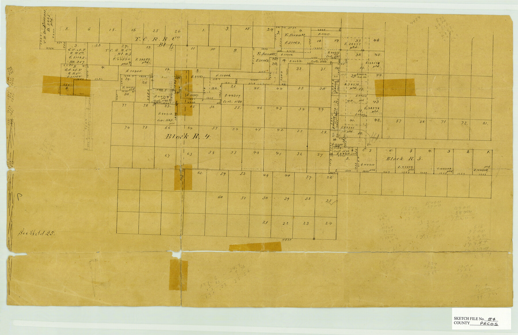
Pecos County Sketch File 54
Office Sketch in Blocks 1, R4 & R5, Pecos County, Texas
-
Map/Doc
12180
-
Collection
General Map Collection
-
Counties
Pecos Brewster Terrell
-
Subjects
Surveying Sketch File
-
Height x Width
14.5 x 22.4 inches
36.8 x 56.9 cm
-
Medium
paper, manuscript
Part of: General Map Collection
Galveston County NRC Article 33.136 Location Key Sheet

Print $20.00
- Digital $50.00
Galveston County NRC Article 33.136 Location Key Sheet
1993
Size 27.3 x 23.0 inches
Map/Doc 83000
Flight Mission No. CRE-1R, Frame 120, Jackson County

Print $20.00
- Digital $50.00
Flight Mission No. CRE-1R, Frame 120, Jackson County
1956
Size 16.1 x 15.9 inches
Map/Doc 85331
No. IX - Outline map of the vicinity of Corpus Christi

Print $20.00
- Digital $50.00
No. IX - Outline map of the vicinity of Corpus Christi
Size 24.9 x 18.2 inches
Map/Doc 72966
Medina County Working Sketch 9

Print $20.00
- Digital $50.00
Medina County Working Sketch 9
1959
Size 25.3 x 38.8 inches
Map/Doc 70924
Grayson County Working Sketch 15

Print $20.00
- Digital $50.00
Grayson County Working Sketch 15
1953
Size 24.8 x 20.6 inches
Map/Doc 63254
[Rio Grande & Eagle Pass - Stockdale to Cuero]
![64047, [Rio Grande & Eagle Pass - Stockdale to Cuero], General Map Collection](https://historictexasmaps.com/wmedia_w700/maps/64047.tif.jpg)
Print $40.00
- Digital $50.00
[Rio Grande & Eagle Pass - Stockdale to Cuero]
Size 20.6 x 121.5 inches
Map/Doc 64047
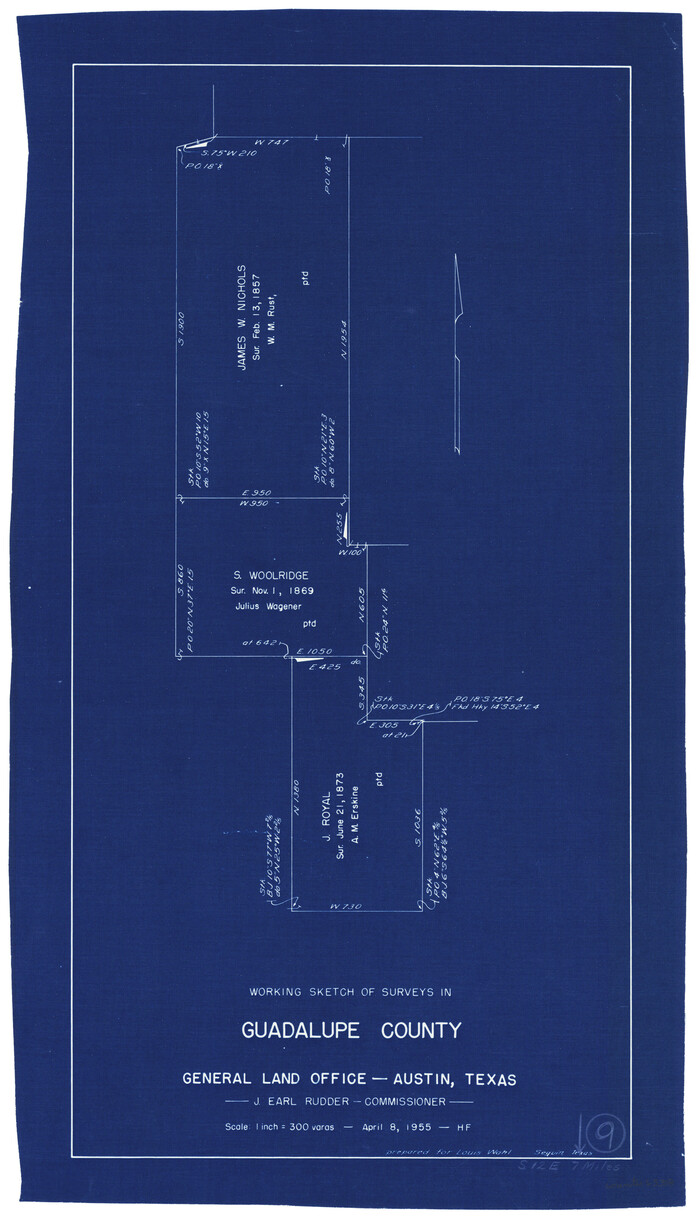
Guadalupe County Working Sketch 9
Print $20.00
- Digital $50.00
Guadalupe County Working Sketch 9
1955
Size 21.9 x 12.6 inches
Map/Doc 63318
Wichita County Working Sketch 1

Print $20.00
- Digital $50.00
Wichita County Working Sketch 1
Size 23.5 x 24.2 inches
Map/Doc 72510
Palo Pinto County Working Sketch 19

Print $40.00
- Digital $50.00
Palo Pinto County Working Sketch 19
1975
Size 34.0 x 55.5 inches
Map/Doc 71402
Wheeler County Sketch File 5

Print $40.00
- Digital $50.00
Wheeler County Sketch File 5
1887
Size 20.2 x 24.2 inches
Map/Doc 12675
Cass County Working Sketch 50

Print $20.00
- Digital $50.00
Cass County Working Sketch 50
Size 42.6 x 37.7 inches
Map/Doc 67953
Val Verde County Sketch File C

Print $62.00
- Digital $50.00
Val Verde County Sketch File C
1898
Size 15.5 x 19.8 inches
Map/Doc 12545
You may also like
Concho County Sketch File 18

Print $32.00
- Digital $50.00
Concho County Sketch File 18
1898
Size 9.1 x 4.4 inches
Map/Doc 19137
[John P. Rohus and surrounding surveys]
![90974, [John P. Rohus and surrounding surveys], Twichell Survey Records](https://historictexasmaps.com/wmedia_w700/maps/90974-1.tif.jpg)
Print $20.00
- Digital $50.00
[John P. Rohus and surrounding surveys]
Size 26.1 x 19.9 inches
Map/Doc 90974
Taylor County Sketch File 11

Print $20.00
- Digital $50.00
Taylor County Sketch File 11
Size 34.8 x 28.3 inches
Map/Doc 10384
Flight Mission No. BRA-8M, Frame 22, Jefferson County

Print $20.00
- Digital $50.00
Flight Mission No. BRA-8M, Frame 22, Jefferson County
1953
Size 18.5 x 22.4 inches
Map/Doc 85577
Trinity River, White Rock Reservoir Sheet/White Rock Creek

Print $6.00
- Digital $50.00
Trinity River, White Rock Reservoir Sheet/White Rock Creek
1923
Size 36.3 x 16.7 inches
Map/Doc 65213
Navarro County Working Sketch 1c

Print $2.00
- Digital $50.00
Navarro County Working Sketch 1c
Size 7.1 x 10.6 inches
Map/Doc 71231
Brown County Working Sketch 8

Print $20.00
- Digital $50.00
Brown County Working Sketch 8
1974
Size 43.8 x 27.7 inches
Map/Doc 67773
General Highway Map, Childress County, Texas

Print $20.00
General Highway Map, Childress County, Texas
1961
Size 18.2 x 24.8 inches
Map/Doc 79408
[Capitol Lands in Lamb County]
![90996, [Capitol Lands in Lamb County], Twichell Survey Records](https://historictexasmaps.com/wmedia_w700/maps/90996-1.tif.jpg)
Print $20.00
- Digital $50.00
[Capitol Lands in Lamb County]
1903
Size 31.0 x 11.8 inches
Map/Doc 90996
The Republic County of San Augustine. Boundaries Defined, December 14, 1837

Print $20.00
The Republic County of San Augustine. Boundaries Defined, December 14, 1837
2020
Size 18.8 x 21.7 inches
Map/Doc 96271
Flight Mission No. CGI-1N, Frame 214, Cameron County

Print $20.00
- Digital $50.00
Flight Mission No. CGI-1N, Frame 214, Cameron County
1955
Size 18.5 x 22.1 inches
Map/Doc 84523
Blanco County Sketch File 31

Print $4.00
- Digital $50.00
Blanco County Sketch File 31
Size 11.1 x 8.6 inches
Map/Doc 14629