Wheeler County Sketch File 5
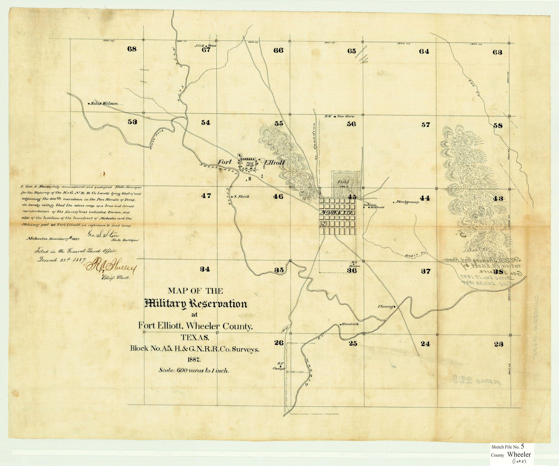
Map of the Military Reservation at Fort Elliott, Wheeler County, Texas, Block No. A5, H. & G. N. R.R. Co. Surveys
-
Map/Doc
12675
-
Collection
General Map Collection
-
Object Dates
12/17/1887 (Creation Date)
12/23/1887 (File Date)
-
People and Organizations
George S. Storrs (Surveyor/Engineer)
-
Counties
Wheeler
-
Subjects
Surveying Sketch File Military
-
Height x Width
20.2 x 24.2 inches
51.3 x 61.5 cm
-
Medium
multi-page, multi-format
-
Scale
1" = 600 varas
-
Features
North Fork of Sweetwater Creek
South Fork of Sweetwater Creek
[Road] to Canadian
Lee Creek
Dobie Creek
Mobeetie
Fort Elliott
Military Reservation
Graham Creek
Part of: General Map Collection
Angelina County Working Sketch 57

Print $20.00
- Digital $50.00
Angelina County Working Sketch 57
Size 18.0 x 20.3 inches
Map/Doc 78285
Gulf Oil Corp. Fishgide - Matagorda

Gulf Oil Corp. Fishgide - Matagorda
1960
Size 12.4 x 22.4 inches
Map/Doc 75976
Harris County Rolled Sketch 77

Print $20.00
- Digital $50.00
Harris County Rolled Sketch 77
1914
Size 30.0 x 35.6 inches
Map/Doc 6114
Outer Continental Shelf Leasing Maps (Louisiana Offshore Operations)

Print $20.00
- Digital $50.00
Outer Continental Shelf Leasing Maps (Louisiana Offshore Operations)
1959
Size 17.7 x 13.9 inches
Map/Doc 76114
[Map showing S. A. & A. P. Ry. from San Antonio to Kendall County line]
![64255, [Map showing S. A. & A. P. Ry. from San Antonio to Kendall County line], General Map Collection](https://historictexasmaps.com/wmedia_w700/maps/64255.tif.jpg)
Print $40.00
- Digital $50.00
[Map showing S. A. & A. P. Ry. from San Antonio to Kendall County line]
1895
Size 25.5 x 70.7 inches
Map/Doc 64255
Pecos County Rolled Sketch 168

Print $40.00
- Digital $50.00
Pecos County Rolled Sketch 168
Size 73.5 x 44.7 inches
Map/Doc 9748
Map of subdivision of submerged land in the Gulf of Mexico fronting on Matagorda Island and Peninsula

Print $40.00
- Digital $50.00
Map of subdivision of submerged land in the Gulf of Mexico fronting on Matagorda Island and Peninsula
1940
Size 22.8 x 76.5 inches
Map/Doc 2932
Galveston County Sketch File 9

Print $6.00
- Digital $50.00
Galveston County Sketch File 9
1866
Size 10.1 x 8.1 inches
Map/Doc 23369
Galveston County NRC Article 33.136 Sketch 87

Print $24.00
- Digital $50.00
Galveston County NRC Article 33.136 Sketch 87
2006
Size 24.0 x 36.0 inches
Map/Doc 95391
Menard County Sketch File 22

Print $8.00
- Digital $50.00
Menard County Sketch File 22
1927
Size 7.4 x 8.6 inches
Map/Doc 31553
Lavaca County Working Sketch 12

Print $20.00
- Digital $50.00
Lavaca County Working Sketch 12
1954
Size 17.3 x 32.4 inches
Map/Doc 70365
Kimble County Working Sketch 45

Print $20.00
- Digital $50.00
Kimble County Working Sketch 45
1950
Size 26.4 x 28.5 inches
Map/Doc 70113
You may also like
North Line of Lynn County and South Line of Lubbock County

Print $20.00
- Digital $50.00
North Line of Lynn County and South Line of Lubbock County
1892
Size 8.0 x 34.2 inches
Map/Doc 91393
Jasper County Sketch File 17

Print $20.00
- Digital $50.00
Jasper County Sketch File 17
1886
Size 27.5 x 35.4 inches
Map/Doc 10505
Dimmit County Working Sketch 22

Print $20.00
- Digital $50.00
Dimmit County Working Sketch 22
1951
Size 37.3 x 38.7 inches
Map/Doc 68683
[T. & P. Block 33, Township 4N]
![90558, [T. & P. Block 33, Township 4N], Twichell Survey Records](https://historictexasmaps.com/wmedia_w700/maps/90558-1.tif.jpg)
Print $3.00
- Digital $50.00
[T. & P. Block 33, Township 4N]
Size 9.4 x 14.2 inches
Map/Doc 90558
Gray County Boundary File 1

Print $10.00
- Digital $50.00
Gray County Boundary File 1
Size 11.4 x 8.8 inches
Map/Doc 53845
![88993, San Jacinto Co[unty], Library of Congress](https://historictexasmaps.com/wmedia_w700/maps/88993.tif.jpg)
Brewster County Sketch File N-14

Print $24.00
- Digital $50.00
Brewster County Sketch File N-14
1938
Size 14.4 x 8.9 inches
Map/Doc 15629
Flight Mission No. BRA-16M, Frame 178, Jefferson County

Print $20.00
- Digital $50.00
Flight Mission No. BRA-16M, Frame 178, Jefferson County
1953
Size 18.6 x 22.4 inches
Map/Doc 85776
Colton's "New Medium" Map of the State of Texas, the Indian Territory, etc. from the latest & most authentic sources

Print $20.00
- Digital $50.00
Colton's "New Medium" Map of the State of Texas, the Indian Territory, etc. from the latest & most authentic sources
1884
Size 25.4 x 29.5 inches
Map/Doc 96524
Metal Straight Edge Scale 1/20,000 Yard

Metal Straight Edge Scale 1/20,000 Yard
Size 24.0 x 1.6 inches
Map/Doc 97323
Brewster County Working Sketch 53

Print $20.00
- Digital $50.00
Brewster County Working Sketch 53
1951
Size 32.1 x 16.5 inches
Map/Doc 67587
Flight Mission No. DQN-1K, Frame 27, Calhoun County

Print $20.00
- Digital $50.00
Flight Mission No. DQN-1K, Frame 27, Calhoun County
1953
Size 18.5 x 22.1 inches
Map/Doc 84132