Wheeler County Sketch File 5

Print $40.00
- Digital $50.00
Wheeler County Sketch File 5
1887
Size: 20.2 x 24.2 inches
12675
Sketch showing the route of the military road from Red River to Austin

Print $20.00
- Digital $50.00
Sketch showing the route of the military road from Red River to Austin
1840
Size: 33.2 x 13.1 inches
1752
Map of the reconnaissance in Texas by Lieuts Blake & Meade of the Corps of Topl. Engs.

Print $20.00
- Digital $50.00
Map of the reconnaissance in Texas by Lieuts Blake & Meade of the Corps of Topl. Engs.
1846
Size: 27.1 x 22.5 inches
2003
Sketch of the route from the camp on the Concho River to Phantom Hill, Texas

Print $20.00
- Digital $50.00
Sketch of the route from the camp on the Concho River to Phantom Hill, Texas
1852
Size: 30.0 x 11.9 inches
2005
Sketch of the route taken by a scouting party from Phantom Hill to Double Mountain, Texas

Print $20.00
- Digital $50.00
Sketch of the route taken by a scouting party from Phantom Hill to Double Mountain, Texas
1852
Size: 25.3 x 13.4 inches
2006
Sketch of a road from Fort Croghan to Phantom Hill, Texas

Print $20.00
- Digital $50.00
Sketch of a road from Fort Croghan to Phantom Hill, Texas
1852
Size: 34.7 x 12.2 inches
2007
Map of a Route from Austin-City to Paso del Norte & c.

Print $20.00
- Digital $50.00
Map of a Route from Austin-City to Paso del Norte & c.
1849
Size: 11.7 x 30.5 inches
2121
Texas map showing principal forts

Print $20.00
- Digital $50.00
Texas map showing principal forts
1852
Size: 34.7 x 25.1 inches
2125
Proposed bombing and machine gun restricted areas along Gulf of Mexico from San Luis Pass to Aransas Pass

Print $20.00
- Digital $50.00
Proposed bombing and machine gun restricted areas along Gulf of Mexico from San Luis Pass to Aransas Pass
1941
Size: 11.1 x 24.1 inches
3024
[Military surveys on headwaters of Red River]
Print $20.00
- Digital $50.00
[Military surveys on headwaters of Red River]
1878
Size: 31.6 x 39.0 inches
3099
Map of the Rio Grande Frontier, Texas, East of Fort McIntosh and South of the Mex. National RR.

Print $20.00
- Digital $50.00
Map of the Rio Grande Frontier, Texas, East of Fort McIntosh and South of the Mex. National RR.
1892
Size: 26.1 x 39.8 inches
4660
Calhoun County Rolled Sketch 11

Print $20.00
- Digital $50.00
Calhoun County Rolled Sketch 11
1942
Size: 10.6 x 40.7 inches
5367
Rebel Defenses of Galveston and Vicinity

Print $20.00
- Digital $50.00
Rebel Defenses of Galveston and Vicinity
1865
Size: 17.0 x 23.7 inches
61802
Map of the country scouted by Colonels McKenzie and Shafter, Capt. R.P. Wilson and others in the years, 1874 & 1875

Print $20.00
- Digital $50.00
Map of the country scouted by Colonels McKenzie and Shafter, Capt. R.P. Wilson and others in the years, 1874 & 1875
1876
Size: 43.0 x 31.8 inches
62972
Trails made and routes used by the Fourth U.S. Cavalry under command of General R.S. Mackenzie in its operations against hostile indians in Texas, Indian-Territory (now Oklahoma), New Mexico and Old Mexico during the period of 1871-2-3-4 and 5

Print $20.00
- Digital $50.00
Trails made and routes used by the Fourth U.S. Cavalry under command of General R.S. Mackenzie in its operations against hostile indians in Texas, Indian-Territory (now Oklahoma), New Mexico and Old Mexico during the period of 1871-2-3-4 and 5
1927
Size: 37.0 x 34.2 inches
62973
[Map of Lt. Brulls scout in Haskell, Throckmorton, Jones and Shackelford Counties]
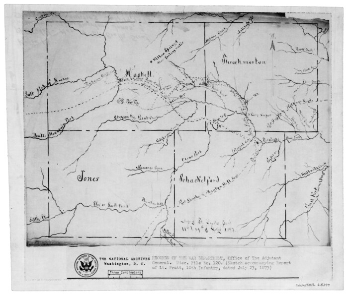
Print $3.00
- Digital $50.00
[Map of Lt. Brulls scout in Haskell, Throckmorton, Jones and Shackelford Counties]
1873
Size: 10.1 x 11.9 inches
65399
Map of scout of second column, Indian Territory Expedition, 1874

Print $4.00
- Digital $50.00
Map of scout of second column, Indian Territory Expedition, 1874
1874
Size: 20.2 x 16.4 inches
65401
Map of parts of Texas, Mexico and New Mexico

Print $4.00
- Digital $50.00
Map of parts of Texas, Mexico and New Mexico
1877
Size: 18.1 x 21.8 inches
65403
[Sketch of expeditions, trails in Jones, Taylor, Shackelford, Callahan, Buchanan/Stephens and Eastland Counties]
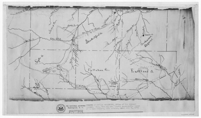
Print $4.00
- Digital $50.00
[Sketch of expeditions, trails in Jones, Taylor, Shackelford, Callahan, Buchanan/Stephens and Eastland Counties]
1873
Size: 10.8 x 18.3 inches
65405
[Sketch of expeditions, trails in Jones, Taylor, Shackelford, Callahan, Buchanan/Stephens and Eastland Counties]
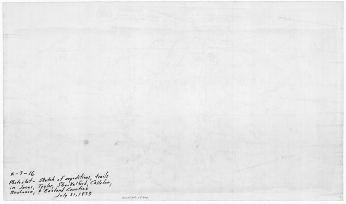
Print $4.00
- Digital $50.00
[Sketch of expeditions, trails in Jones, Taylor, Shackelford, Callahan, Buchanan/Stephens and Eastland Counties]
1873
Size: 10.7 x 18.1 inches
65406
Map accompanying report of scout made by 2nd Lt. F. de I. Carrington. 1st Infantry

Print $20.00
- Digital $50.00
Map accompanying report of scout made by 2nd Lt. F. de I. Carrington. 1st Infantry
1881
Size: 22.2 x 18.0 inches
65407
Coast of Texas and its defences

Print $20.00
- Digital $50.00
Coast of Texas and its defences
1864
Size: 27.3 x 18.1 inches
72683
Coast of Texas and its defences

Print $20.00
- Digital $50.00
Coast of Texas and its defences
Size: 27.8 x 18.2 inches
72684
Coast of Texas and its defences

Print $20.00
- Digital $50.00
Coast of Texas and its defences
Size: 27.6 x 18.2 inches
72685
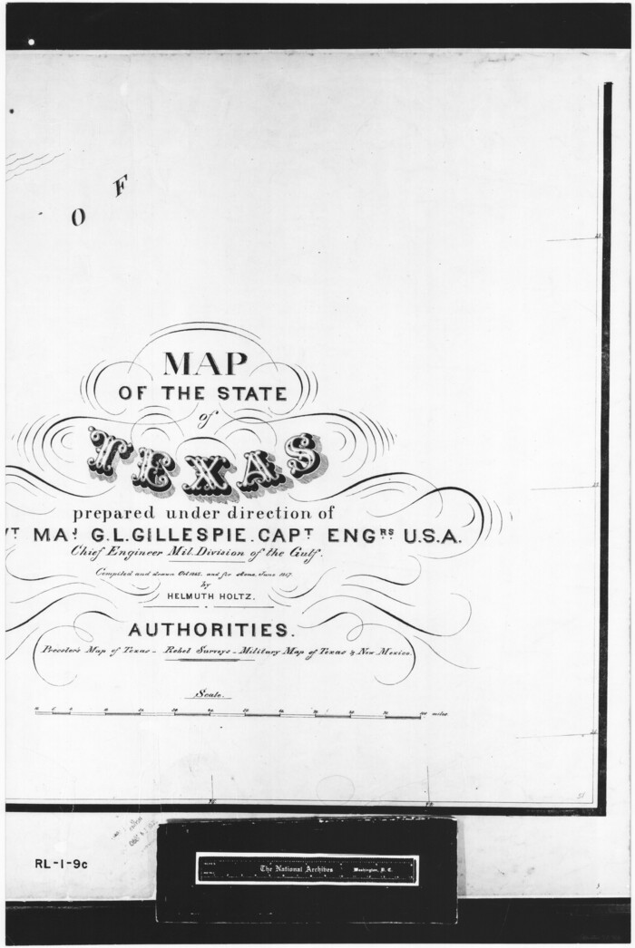
[Gulf Coast portion of] Map of the State of Texas
Print $20.00
- Digital $50.00
[Gulf Coast portion of] Map of the State of Texas
1865
Size: 27.2 x 18.2 inches
72706
Sketch of a portion of the Texas Coast showing the relative positions of different harbours with the interior Military Posts, and the roads communicating with them, also two new routes from Black Point and Lamar to San Antonio

Print $20.00
- Digital $50.00
Sketch of a portion of the Texas Coast showing the relative positions of different harbours with the interior Military Posts, and the roads communicating with them, also two new routes from Black Point and Lamar to San Antonio
1855
Size: 27.3 x 18.3 inches
72709
Sketch of a portion of the Texas Coast showing the relative positions of different harbours with the interior Military Posts, and the roads communicating with them, also two new routes from Black Point and Lamar to San Antonio

Print $20.00
- Digital $50.00
Sketch of a portion of the Texas Coast showing the relative positions of different harbours with the interior Military Posts, and the roads communicating with them, also two new routes from Black Point and Lamar to San Antonio
1855
Size: 27.3 x 18.3 inches
72710
Sketch of a portion of the Texas Coast showing the relative positions of different harbours with the interior Military Posts, and the roads communicating with them, also two new routes from Black Point and Lamar to San Antonio

Print $20.00
- Digital $50.00
Sketch of a portion of the Texas Coast showing the relative positions of different harbours with the interior Military Posts, and the roads communicating with them, also two new routes from Black Point and Lamar to San Antonio
1855
Size: 27.2 x 18.3 inches
72711
Map of the country in the vicinity of San Antonio de Bexar reduced in part from the county map of Bexar with additions by J. Edmd. Blake, 1st Lieut Topl. Engs.

Print $20.00
- Digital $50.00
Map of the country in the vicinity of San Antonio de Bexar reduced in part from the county map of Bexar with additions by J. Edmd. Blake, 1st Lieut Topl. Engs.
1845
Size: 18.1 x 25.9 inches
72723
Sketch of the line of march of the 2nd US Dragoons commanded by Col D. E. Tuiggs from Fort Jesup, La to Corpus Christi, Texas between the 25th of July and the 27th Aug, 1845

Print $20.00
- Digital $50.00
Sketch of the line of march of the 2nd US Dragoons commanded by Col D. E. Tuiggs from Fort Jesup, La to Corpus Christi, Texas between the 25th of July and the 27th Aug, 1845
1845
Size: 25.4 x 18.3 inches
72724
Wheeler County Sketch File 5
Print $40.00
- Digital $50.00
Wheeler County Sketch File 5
1887
-
Size
20.2 x 24.2 inches
-
Map/Doc
12675
-
Creation Date
1887
Sketch showing the route of the military road from Red River to Austin
Print $20.00
- Digital $50.00
Sketch showing the route of the military road from Red River to Austin
1840
-
Size
33.2 x 13.1 inches
-
Map/Doc
1752
-
Creation Date
1840
Map of the reconnaissance in Texas by Lieuts Blake & Meade of the Corps of Topl. Engs.
Print $20.00
- Digital $50.00
Map of the reconnaissance in Texas by Lieuts Blake & Meade of the Corps of Topl. Engs.
1846
-
Size
27.1 x 22.5 inches
-
Map/Doc
2003
-
Creation Date
1846
Sketch of the route from the camp on the Concho River to Phantom Hill, Texas
Print $20.00
- Digital $50.00
Sketch of the route from the camp on the Concho River to Phantom Hill, Texas
1852
-
Size
30.0 x 11.9 inches
-
Map/Doc
2005
-
Creation Date
1852
Sketch of the route taken by a scouting party from Phantom Hill to Double Mountain, Texas
Print $20.00
- Digital $50.00
Sketch of the route taken by a scouting party from Phantom Hill to Double Mountain, Texas
1852
-
Size
25.3 x 13.4 inches
-
Map/Doc
2006
-
Creation Date
1852
Sketch of a road from Fort Croghan to Phantom Hill, Texas
Print $20.00
- Digital $50.00
Sketch of a road from Fort Croghan to Phantom Hill, Texas
1852
-
Size
34.7 x 12.2 inches
-
Map/Doc
2007
-
Creation Date
1852
Map of a Route from Austin-City to Paso del Norte & c.
Print $20.00
- Digital $50.00
Map of a Route from Austin-City to Paso del Norte & c.
1849
-
Size
11.7 x 30.5 inches
-
Map/Doc
2121
-
Creation Date
1849
Texas map showing principal forts
Print $20.00
- Digital $50.00
Texas map showing principal forts
1852
-
Size
34.7 x 25.1 inches
-
Map/Doc
2125
-
Creation Date
1852
Proposed bombing and machine gun restricted areas along Gulf of Mexico from San Luis Pass to Aransas Pass
Print $20.00
- Digital $50.00
Proposed bombing and machine gun restricted areas along Gulf of Mexico from San Luis Pass to Aransas Pass
1941
-
Size
11.1 x 24.1 inches
-
Map/Doc
3024
-
Creation Date
1941
[Military surveys on headwaters of Red River]
Print $20.00
- Digital $50.00
[Military surveys on headwaters of Red River]
1878
-
Size
31.6 x 39.0 inches
-
Map/Doc
3099
-
Creation Date
1878
Map of the Rio Grande Frontier, Texas, East of Fort McIntosh and South of the Mex. National RR.
Print $20.00
- Digital $50.00
Map of the Rio Grande Frontier, Texas, East of Fort McIntosh and South of the Mex. National RR.
1892
-
Size
26.1 x 39.8 inches
-
Map/Doc
4660
-
Creation Date
1892
Calhoun County Rolled Sketch 11
Print $20.00
- Digital $50.00
Calhoun County Rolled Sketch 11
1942
-
Size
10.6 x 40.7 inches
-
Map/Doc
5367
-
Creation Date
1942
Rebel Defenses of Galveston and Vicinity
Print $20.00
- Digital $50.00
Rebel Defenses of Galveston and Vicinity
1865
-
Size
17.0 x 23.7 inches
-
Map/Doc
61802
-
Creation Date
1865
Map of the country scouted by Colonels McKenzie and Shafter, Capt. R.P. Wilson and others in the years, 1874 & 1875
Print $20.00
- Digital $50.00
Map of the country scouted by Colonels McKenzie and Shafter, Capt. R.P. Wilson and others in the years, 1874 & 1875
1876
-
Size
43.0 x 31.8 inches
-
Map/Doc
62972
-
Creation Date
1876
Trails made and routes used by the Fourth U.S. Cavalry under command of General R.S. Mackenzie in its operations against hostile indians in Texas, Indian-Territory (now Oklahoma), New Mexico and Old Mexico during the period of 1871-2-3-4 and 5
Print $20.00
- Digital $50.00
Trails made and routes used by the Fourth U.S. Cavalry under command of General R.S. Mackenzie in its operations against hostile indians in Texas, Indian-Territory (now Oklahoma), New Mexico and Old Mexico during the period of 1871-2-3-4 and 5
1927
-
Size
37.0 x 34.2 inches
-
Map/Doc
62973
-
Creation Date
1927
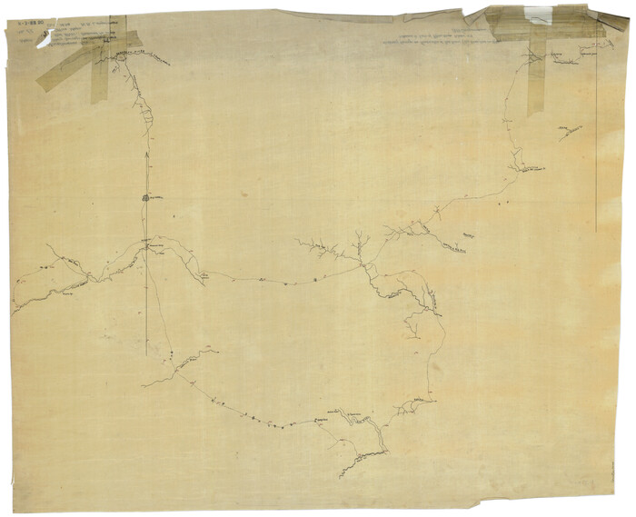
[Map of Lt. Brulls scout in Haskell, Throckmorton, Jones and Shackelford Counties]
Print $3.00
- Digital $50.00
[Map of Lt. Brulls scout in Haskell, Throckmorton, Jones and Shackelford Counties]
1873
-
Size
10.1 x 11.9 inches
-
Map/Doc
65399
-
Creation Date
1873
Map of scout of second column, Indian Territory Expedition, 1874
Print $4.00
- Digital $50.00
Map of scout of second column, Indian Territory Expedition, 1874
1874
-
Size
20.2 x 16.4 inches
-
Map/Doc
65401
-
Creation Date
1874
Map of parts of Texas, Mexico and New Mexico
Print $4.00
- Digital $50.00
Map of parts of Texas, Mexico and New Mexico
1877
-
Size
18.1 x 21.8 inches
-
Map/Doc
65403
-
Creation Date
1877
[Sketch of expeditions, trails in Jones, Taylor, Shackelford, Callahan, Buchanan/Stephens and Eastland Counties]
Print $4.00
- Digital $50.00
[Sketch of expeditions, trails in Jones, Taylor, Shackelford, Callahan, Buchanan/Stephens and Eastland Counties]
1873
-
Size
10.8 x 18.3 inches
-
Map/Doc
65405
-
Creation Date
1873
[Sketch of expeditions, trails in Jones, Taylor, Shackelford, Callahan, Buchanan/Stephens and Eastland Counties]
Print $4.00
- Digital $50.00
[Sketch of expeditions, trails in Jones, Taylor, Shackelford, Callahan, Buchanan/Stephens and Eastland Counties]
1873
-
Size
10.7 x 18.1 inches
-
Map/Doc
65406
-
Creation Date
1873
Map accompanying report of scout made by 2nd Lt. F. de I. Carrington. 1st Infantry
Print $20.00
- Digital $50.00
Map accompanying report of scout made by 2nd Lt. F. de I. Carrington. 1st Infantry
1881
-
Size
22.2 x 18.0 inches
-
Map/Doc
65407
-
Creation Date
1881
Coast of Texas and its defences
Print $20.00
- Digital $50.00
Coast of Texas and its defences
1864
-
Size
27.3 x 18.1 inches
-
Map/Doc
72683
-
Creation Date
1864
Coast of Texas and its defences
Print $20.00
- Digital $50.00
Coast of Texas and its defences
-
Size
27.8 x 18.2 inches
-
Map/Doc
72684
Coast of Texas and its defences
Print $20.00
- Digital $50.00
Coast of Texas and its defences
-
Size
27.6 x 18.2 inches
-
Map/Doc
72685
[Gulf Coast portion of] Map of the State of Texas
Print $20.00
- Digital $50.00
[Gulf Coast portion of] Map of the State of Texas
1865
-
Size
27.2 x 18.2 inches
-
Map/Doc
72706
-
Creation Date
1865
Sketch of a portion of the Texas Coast showing the relative positions of different harbours with the interior Military Posts, and the roads communicating with them, also two new routes from Black Point and Lamar to San Antonio
Print $20.00
- Digital $50.00
Sketch of a portion of the Texas Coast showing the relative positions of different harbours with the interior Military Posts, and the roads communicating with them, also two new routes from Black Point and Lamar to San Antonio
1855
-
Size
27.3 x 18.3 inches
-
Map/Doc
72709
-
Creation Date
1855
Sketch of a portion of the Texas Coast showing the relative positions of different harbours with the interior Military Posts, and the roads communicating with them, also two new routes from Black Point and Lamar to San Antonio
Print $20.00
- Digital $50.00
Sketch of a portion of the Texas Coast showing the relative positions of different harbours with the interior Military Posts, and the roads communicating with them, also two new routes from Black Point and Lamar to San Antonio
1855
-
Size
27.3 x 18.3 inches
-
Map/Doc
72710
-
Creation Date
1855
Sketch of a portion of the Texas Coast showing the relative positions of different harbours with the interior Military Posts, and the roads communicating with them, also two new routes from Black Point and Lamar to San Antonio
Print $20.00
- Digital $50.00
Sketch of a portion of the Texas Coast showing the relative positions of different harbours with the interior Military Posts, and the roads communicating with them, also two new routes from Black Point and Lamar to San Antonio
1855
-
Size
27.2 x 18.3 inches
-
Map/Doc
72711
-
Creation Date
1855
Map of the country in the vicinity of San Antonio de Bexar reduced in part from the county map of Bexar with additions by J. Edmd. Blake, 1st Lieut Topl. Engs.
Print $20.00
- Digital $50.00
Map of the country in the vicinity of San Antonio de Bexar reduced in part from the county map of Bexar with additions by J. Edmd. Blake, 1st Lieut Topl. Engs.
1845
-
Size
18.1 x 25.9 inches
-
Map/Doc
72723
-
Creation Date
1845
Sketch of the line of march of the 2nd US Dragoons commanded by Col D. E. Tuiggs from Fort Jesup, La to Corpus Christi, Texas between the 25th of July and the 27th Aug, 1845
Print $20.00
- Digital $50.00
Sketch of the line of march of the 2nd US Dragoons commanded by Col D. E. Tuiggs from Fort Jesup, La to Corpus Christi, Texas between the 25th of July and the 27th Aug, 1845
1845
-
Size
25.4 x 18.3 inches
-
Map/Doc
72724
-
Creation Date
1845