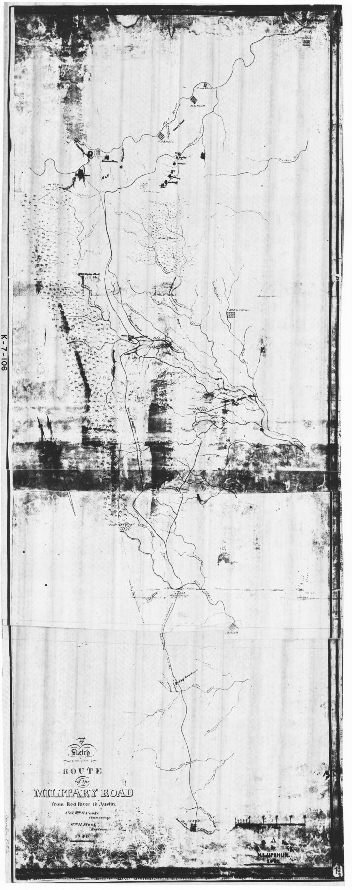
Sketch showing the route of the military road from Red River to Austin
K-7-106
-
Map/Doc
1752
-
Collection
General Map Collection
-
Object Dates
1840 (Creation Date)
-
People and Organizations
Wm. G. Cooke (Author)
William H. Hunt (Surveyor/Engineer)
H.L. Upshur (Draftsman)
-
Subjects
Military
-
Height x Width
33.2 x 13.1 inches
84.3 x 33.3 cm
-
Medium
photostat
-
Scale
10 miles to 1 inch
-
Comments
Several Indian Villages marked. See maps 166 and 82146 for initial sketches for this map.
-
Features
Indian Village
Tahuacana Creek
Aguila Creek
Toweash Village
Lee's Creek
Navisoto [sic] River
Lake Shackelford
Richland Creek
Chamber's Creek
Robertson's Creek
Brazos Bayou
Indian Trail
Goodall's Creek
Camp Creek
Neill's Lake
Clendening Creek
Main Trinidad River
West Fork of Trinity River
Houghton's Creek
Cedar Springs Post on Trinity
Bird's Battle Ground
Colorado River
Austin
Walnut Creek
Brushy Creek
Kinney's Fort
San Gabriel River
Opossum Creek
Lampasis [sic] Creek
Salado Creek
King's Fork of Rio Trinidad
San Leon River
Little River
Elm Creek
Milam
Cow Creek
Route Reconnaissance by Engineer
Rio Bosque
Waco Village
Post on Brazos [River]
Red River
Pilot Grove
Gilbert's [house]
Sulphur Fork [of Red River]
Coffee's Station
False Washita [River]
English's [house]
Caney Creek
Warren
Bois d'Arc River
Pilot Grove Creek
Raleigh
Beal's Ferry
Jonesboro
Kiamichi Creek
Fort Towsen
Pilot Creek
Martin's Creek
Mustang Creek
Route recommended by Engineer
Scott's Creek
Kingsburg
Skerrett's Creek
Elm Fork of the Trinity River
Cooke's Creek
Bois d'Ark Fork of Trinity River
Brushey [sic] Bayou
Sevey's Creek
Stock's Creek
Haro Thicket
Col. Cooke's Route from Austin to Red River
Col. Cooke's Trail
Sabine River
Mineral Creek
Hornsbey's [sic] Creek
Holliday's Creek
Archer's Creek
Robert's Creek
Post on Red River
Chihuahua Road
Related maps
[Sketch of Col. Cooke's Military Road expedition from Red River to Austin]
![166, [Sketch of Col. Cooke's Military Road expedition from Red River to Austin], General Map Collection](https://historictexasmaps.com/wmedia_w700/maps/166.tif.jpg)
Print $20.00
- Digital $50.00
[Sketch of Col. Cooke's Military Road expedition from Red River to Austin]
Size 29.4 x 22.9 inches
Map/Doc 166
[Sketch of Col. Cooke's Military Road expedition from Red River to Austin]
![82146, [Sketch of Col. Cooke's Military Road expedition from Red River to Austin], General Map Collection](https://historictexasmaps.com/wmedia_w700/maps/82146-1.tif.jpg)
Print $20.00
- Digital $50.00
[Sketch of Col. Cooke's Military Road expedition from Red River to Austin]
Size 33.4 x 23.4 inches
Map/Doc 82146
[Sketch of Col. Cooke's Military Road expedition from Red River to Austin]
![82272, [Sketch of Col. Cooke's Military Road expedition from Red River to Austin], General Map Collection](https://historictexasmaps.com/wmedia_w700/maps/82272-1.tif.jpg)
Print $40.00
- Digital $50.00
[Sketch of Col. Cooke's Military Road expedition from Red River to Austin]
Size 61.0 x 24.1 inches
Map/Doc 82272
Part of: General Map Collection
Map of Presidio County

Print $40.00
- Digital $50.00
Map of Presidio County
1895
Size 53.0 x 38.6 inches
Map/Doc 3968
Brewster County Rolled Sketch 114

Print $20.00
- Digital $50.00
Brewster County Rolled Sketch 114
1964
Size 12.0 x 17.5 inches
Map/Doc 5291
Hutchinson County

Print $20.00
- Digital $50.00
Hutchinson County
1922
Size 45.6 x 38.8 inches
Map/Doc 1863
Jim Hogg County Rolled Sketch 5

Print $20.00
- Digital $50.00
Jim Hogg County Rolled Sketch 5
1943
Size 19.9 x 24.1 inches
Map/Doc 6441
Brazoria County Rolled Sketch 18B

Print $20.00
- Digital $50.00
Brazoria County Rolled Sketch 18B
1914
Size 10.0 x 17.3 inches
Map/Doc 5165
Flight Mission No. DQN-5K, Frame 33, Calhoun County

Print $20.00
- Digital $50.00
Flight Mission No. DQN-5K, Frame 33, Calhoun County
1953
Size 18.5 x 22.3 inches
Map/Doc 84384

Nueces County Rolled Sketch 33

Print $47.00
- Digital $50.00
Nueces County Rolled Sketch 33
1953
Size 10.0 x 15.1 inches
Map/Doc 47612
Coke County Working Sketch 1

Print $20.00
- Digital $50.00
Coke County Working Sketch 1
Size 16.3 x 36.2 inches
Map/Doc 68038
Map of the Recognised Line M. EL. P. & P. R. R. from East Line of Bexar Land District to El Paso

Print $40.00
- Digital $50.00
Map of the Recognised Line M. EL. P. & P. R. R. from East Line of Bexar Land District to El Paso
1857
Size 20.0 x 50.4 inches
Map/Doc 85322
Origin of Imports and Destination of Exports at Galveston, Tex., during 1921

Print $20.00
- Digital $50.00
Origin of Imports and Destination of Exports at Galveston, Tex., during 1921
1921
Size 13.1 x 24.6 inches
Map/Doc 97169
El Paso County Boundary File 8

Print $14.00
- Digital $50.00
El Paso County Boundary File 8
Size 12.8 x 8.3 inches
Map/Doc 53104
You may also like
[Map of Connecting Lines along or near the Red River]
![75546, [Map of Connecting Lines along or near the Red River], General Map Collection](https://historictexasmaps.com/wmedia_w700/maps/75546.tif.jpg)
Print $20.00
- Digital $50.00
[Map of Connecting Lines along or near the Red River]
Size 28.6 x 37.0 inches
Map/Doc 75546
Real County Boundary File 1

Print $8.00
- Digital $50.00
Real County Boundary File 1
Size 9.3 x 5.9 inches
Map/Doc 58191
El Paso and the New Southwest

El Paso and the New Southwest
1923
Size 11.8 x 9.0 inches
Map/Doc 97047
Wilbarger Co.

Print $40.00
- Digital $50.00
Wilbarger Co.
1907
Size 49.1 x 40.3 inches
Map/Doc 63126
The Republic County of Matagorda. December 29, 1845

Print $20.00
The Republic County of Matagorda. December 29, 1845
2020
Size 21.0 x 21.7 inches
Map/Doc 96224
Galveston County Sketch File 73

Print $78.00
- Digital $50.00
Galveston County Sketch File 73
1998
Size 11.3 x 8.8 inches
Map/Doc 23980
Flight Mission No. CRC-4R, Frame 95, Chambers County

Print $20.00
- Digital $50.00
Flight Mission No. CRC-4R, Frame 95, Chambers County
1956
Size 18.6 x 22.3 inches
Map/Doc 84892
[Skeleton Sketch of Unlabeled Surveys in Travis County, Texas]
![382, [Skeleton Sketch of Unlabeled Surveys in Travis County, Texas], Maddox Collection](https://historictexasmaps.com/wmedia_w700/maps/382.tif.jpg)
Print $20.00
- Digital $50.00
[Skeleton Sketch of Unlabeled Surveys in Travis County, Texas]
Size 28.9 x 36.8 inches
Map/Doc 382
Freestone County Sketch File 14a

Print $6.00
- Digital $50.00
Freestone County Sketch File 14a
1861
Size 5.3 x 5.9 inches
Map/Doc 23067
Hutchinson County Sketch File 39

Print $20.00
- Digital $50.00
Hutchinson County Sketch File 39
1938
Size 23.5 x 19.0 inches
Map/Doc 11822
Aransas County Working Sketch 3

Print $20.00
- Digital $50.00
Aransas County Working Sketch 3
1928
Size 20.6 x 32.9 inches
Map/Doc 67170
Flight Mission No. CLL-1N, Frame 105, Willacy County

Print $20.00
- Digital $50.00
Flight Mission No. CLL-1N, Frame 105, Willacy County
1954
Size 18.4 x 22.1 inches
Map/Doc 87039