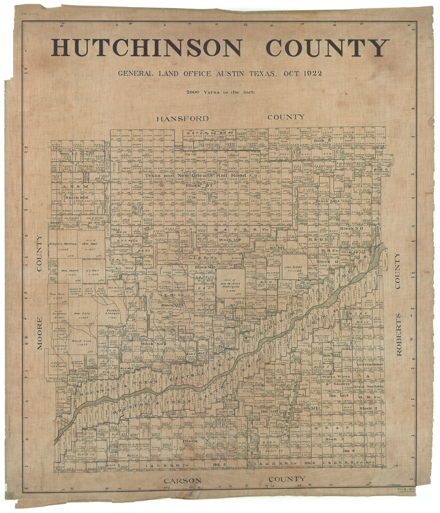
Hutchinson County
RM-3-117
-
Map/Doc
1863
-
Collection
General Map Collection
-
Object Dates
1922 (Creation Date)
-
People and Organizations
Texas General Land Office (Publisher)
H.F. McDonald (Compiler)
H.F. McDonald (Draftsman)
-
Counties
Hutchinson
-
Subjects
County
-
Height x Width
45.6 x 38.8 inches
115.8 x 98.6 cm
Part of: General Map Collection
Eastland County Working Sketch 7

Print $3.00
- Digital $50.00
Eastland County Working Sketch 7
1918
Size 15.6 x 10.7 inches
Map/Doc 68788
Map of Burleson County

Print $20.00
- Digital $50.00
Map of Burleson County
1856
Size 22.0 x 31.5 inches
Map/Doc 3345
Andrews County Working Sketch 18

Print $20.00
- Digital $50.00
Andrews County Working Sketch 18
1964
Size 42.2 x 26.5 inches
Map/Doc 67064
Presidio County Rolled Sketch 54

Print $20.00
- Digital $50.00
Presidio County Rolled Sketch 54
1913
Size 17.1 x 18.5 inches
Map/Doc 7348
Travis County Sketch File 75A

Print $20.00
- Digital $50.00
Travis County Sketch File 75A
1992
Size 37.9 x 28.8 inches
Map/Doc 12478
Childress County Boundary File 2

Print $66.00
- Digital $50.00
Childress County Boundary File 2
Size 7.3 x 3.9 inches
Map/Doc 51306
Kaufman County Boundary File 7

Print $16.00
- Digital $50.00
Kaufman County Boundary File 7
Size 13.9 x 8.7 inches
Map/Doc 55969
University Lands as resurveyed by Frank F. Friend, Special Surveyor, San Angelo, Texas projected on a map of the State of Texas

Print $40.00
- Digital $50.00
University Lands as resurveyed by Frank F. Friend, Special Surveyor, San Angelo, Texas projected on a map of the State of Texas
1936
Size 31.0 x 55.8 inches
Map/Doc 2418
Haskell County Working Sketch 14

Print $20.00
- Digital $50.00
Haskell County Working Sketch 14
1983
Size 34.2 x 40.7 inches
Map/Doc 66072
Clay County Boundary File 10

Print $6.00
- Digital $50.00
Clay County Boundary File 10
Size 14.2 x 8.8 inches
Map/Doc 51397
Milam County Boundary File 65

Print $10.00
- Digital $50.00
Milam County Boundary File 65
Size 8.8 x 7.8 inches
Map/Doc 57251
Duval County Sketch File 54

Print $20.00
- Digital $50.00
Duval County Sketch File 54
1937
Size 19.0 x 26.4 inches
Map/Doc 11403
You may also like
A New Map of Texas with the contiguous American and Mexican States

Print $20.00
- Digital $50.00
A New Map of Texas with the contiguous American and Mexican States
1839
Size 13.0 x 15.4 inches
Map/Doc 96513
Brazoria County Working Sketch 46

Print $40.00
- Digital $50.00
Brazoria County Working Sketch 46
1988
Size 37.3 x 48.7 inches
Map/Doc 67531

[Fragment, Jefferson Plotted]
![78352, [Fragment, Jefferson Plotted], General Map Collection](https://historictexasmaps.com/wmedia_w700/maps/78352.tif.jpg)
Print $2.00
- Digital $50.00
[Fragment, Jefferson Plotted]
Size 14.0 x 7.5 inches
Map/Doc 78352
Edwards County Rolled Sketch 37

Print $20.00
- Digital $50.00
Edwards County Rolled Sketch 37
2018
Size 23.3 x 30.2 inches
Map/Doc 94459
United States - Gulf Coast Texas - Northern part of Laguna Madre

Print $20.00
- Digital $50.00
United States - Gulf Coast Texas - Northern part of Laguna Madre
1941
Size 26.9 x 18.3 inches
Map/Doc 72938
Brewster County Working Sketch 78

Print $20.00
- Digital $50.00
Brewster County Working Sketch 78
1970
Size 31.6 x 44.3 inches
Map/Doc 67678
Mills County Working Sketch 23

Print $20.00
- Digital $50.00
Mills County Working Sketch 23
1985
Size 22.8 x 36.8 inches
Map/Doc 71053
Aransas County NRC Article 33.136 Sketch 4

Print $28.00
- Digital $50.00
Aransas County NRC Article 33.136 Sketch 4
2005
Size 24.3 x 36.5 inches
Map/Doc 83353
Shelby County Sketch File 31

Print $20.00
- Digital $50.00
Shelby County Sketch File 31
1949
Size 12.0 x 36.0 inches
Map/Doc 12320
Map of the Hearne and Brazos Valley Railroad from Mumford to Moseley's Ferry

Print $40.00
- Digital $50.00
Map of the Hearne and Brazos Valley Railroad from Mumford to Moseley's Ferry
1892
Size 20.0 x 56.8 inches
Map/Doc 64400
