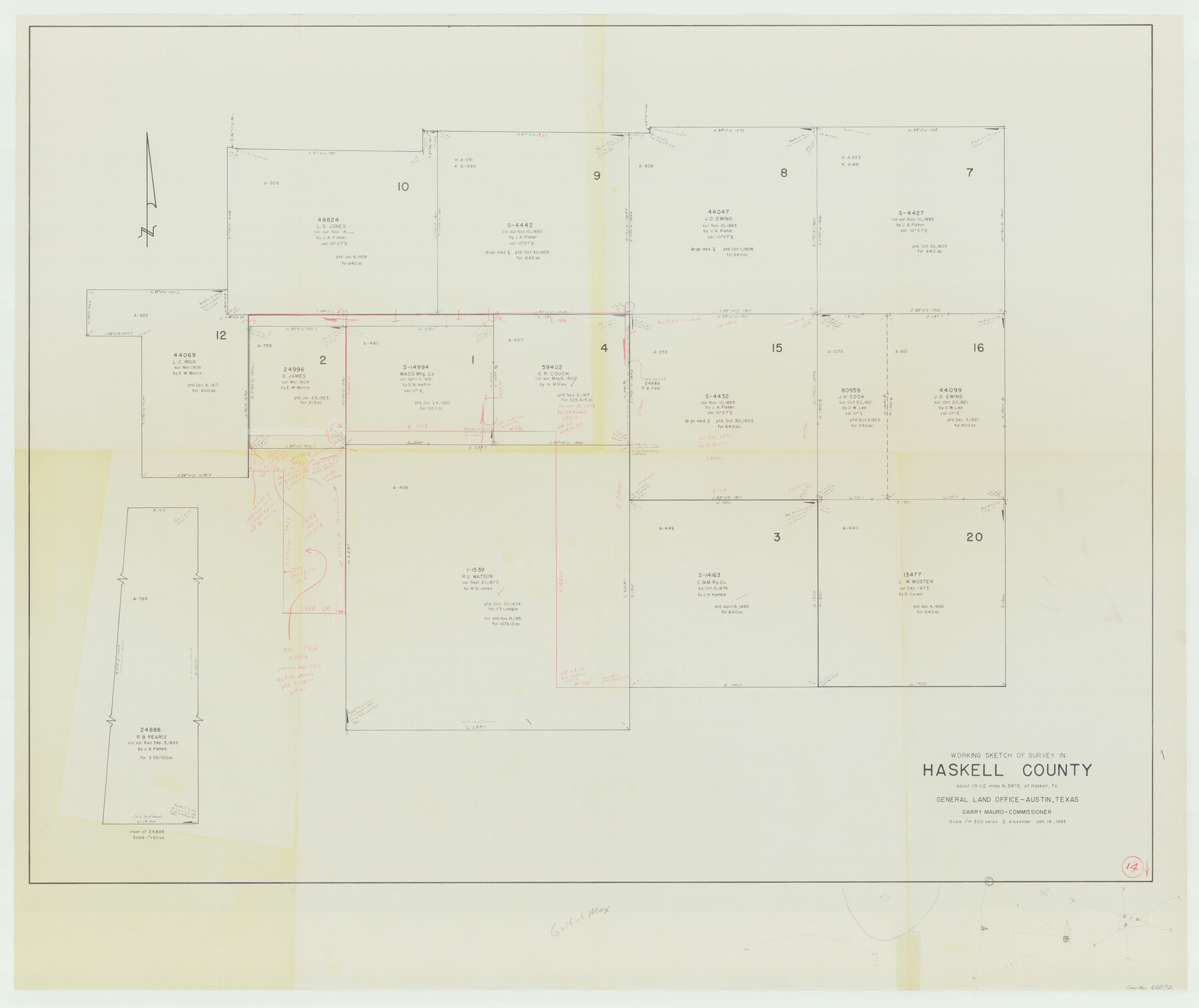
Haskell County Working Sketch 14
-
Map/Doc
66072
-
Collection
General Map Collection
-
Object Dates
1/18/1983 (Creation Date)
-
People and Organizations
Earl Alexander (Draftsman)
-
Counties
Haskell
-
Subjects
Surveying Working Sketch
-
Height x Width
34.2 x 40.7 inches
86.9 x 103.4 cm
-
Scale
1" = 300 varas
Part of: General Map Collection
Panola County Working Sketch 37

Print $20.00
- Digital $50.00
Panola County Working Sketch 37
1984
Map/Doc 71446
Ownership Map of McCulloch County, Texas

Print $20.00
- Digital $50.00
Ownership Map of McCulloch County, Texas
1951
Size 40.5 x 32.5 inches
Map/Doc 3138
Brewster County Working Sketch 12

Print $20.00
- Digital $50.00
Brewster County Working Sketch 12
1924
Size 36.9 x 21.4 inches
Map/Doc 67545
Pecos County Rolled Sketch 149

Print $20.00
- Digital $50.00
Pecos County Rolled Sketch 149
1958
Size 36.0 x 38.5 inches
Map/Doc 9735
Shackelford County Sketch File 16

Print $24.00
- Digital $50.00
Shackelford County Sketch File 16
2005
Size 16.0 x 16.0 inches
Map/Doc 82982
Walker County Working Sketch Graphic Index

Print $20.00
- Digital $50.00
Walker County Working Sketch Graphic Index
1944
Size 43.3 x 36.8 inches
Map/Doc 76729
El Paso County Sketch File 32

Print $8.00
- Digital $50.00
El Paso County Sketch File 32
1983
Size 14.3 x 8.9 inches
Map/Doc 22124
Kleberg County NRC Article 33.136 Location Key Sheet

Print $20.00
- Digital $50.00
Kleberg County NRC Article 33.136 Location Key Sheet
1975
Size 27.0 x 24.0 inches
Map/Doc 77051
Flight Mission No. DQO-8K, Frame 71, Galveston County

Print $20.00
- Digital $50.00
Flight Mission No. DQO-8K, Frame 71, Galveston County
1952
Size 18.6 x 22.4 inches
Map/Doc 85175
Archer County Sketch File 28-1

Print $40.00
- Digital $50.00
Archer County Sketch File 28-1
1928
Size 23.8 x 22.0 inches
Map/Doc 10834
Chambers County Working Sketch 20

Print $20.00
- Digital $50.00
Chambers County Working Sketch 20
1973
Size 25.8 x 30.2 inches
Map/Doc 68003
Newton County Rolled Sketch 25

Print $20.00
- Digital $50.00
Newton County Rolled Sketch 25
1893
Size 17.0 x 21.3 inches
Map/Doc 6855
You may also like
[Maps of surveys in Reeves & Culberson Cos]
![61134, [Maps of surveys in Reeves & Culberson Cos], General Map Collection](https://historictexasmaps.com/wmedia_w700/maps/61134.tif.jpg)
Print $20.00
- Digital $50.00
[Maps of surveys in Reeves & Culberson Cos]
1937
Size 30.7 x 24.9 inches
Map/Doc 61134
[Floyd County Schoo Land Lgs. 180-183, Fisher County School Land Lgs. 105-108, and part of Blk. V]
![90190, [Floyd County Schoo Land Lgs. 180-183, Fisher County School Land Lgs. 105-108, and part of Blk. V], Twichell Survey Records](https://historictexasmaps.com/wmedia_w700/maps/90190-1.tif.jpg)
Print $2.00
- Digital $50.00
[Floyd County Schoo Land Lgs. 180-183, Fisher County School Land Lgs. 105-108, and part of Blk. V]
Size 8.8 x 10.2 inches
Map/Doc 90190
Jeff Davis County Boundary File 1a

Print $8.00
- Digital $50.00
Jeff Davis County Boundary File 1a
Size 14.3 x 8.8 inches
Map/Doc 55501
Harris County Rolled Sketch F

Print $40.00
- Digital $50.00
Harris County Rolled Sketch F
1933
Size 56.6 x 44.6 inches
Map/Doc 9121
Northwest Part Pecos County

Print $20.00
- Digital $50.00
Northwest Part Pecos County
1975
Size 43.4 x 44.2 inches
Map/Doc 95612
Freestone County Working Sketch 5

Print $40.00
- Digital $50.00
Freestone County Working Sketch 5
Size 37.8 x 67.4 inches
Map/Doc 69247
Amistad International Reservoir on Rio Grande 74

Print $20.00
- Digital $50.00
Amistad International Reservoir on Rio Grande 74
1949
Size 28.5 x 40.2 inches
Map/Doc 75501
Gulf Oil Corp. Fishgide - Port O'Connor

Gulf Oil Corp. Fishgide - Port O'Connor
1960
Size 12.2 x 22.3 inches
Map/Doc 75983
Flight Mission No. BRA-7M, Frame 136, Jefferson County

Print $20.00
- Digital $50.00
Flight Mission No. BRA-7M, Frame 136, Jefferson County
1953
Size 18.7 x 22.5 inches
Map/Doc 85530
Floyd County Rolled Sketch 8

Print $20.00
- Digital $50.00
Floyd County Rolled Sketch 8
1947
Size 29.6 x 19.9 inches
Map/Doc 5882
Dimmit County Rolled Sketch 2

Print $20.00
- Digital $50.00
Dimmit County Rolled Sketch 2
Size 33.9 x 39.6 inches
Map/Doc 8793
