Archer County Sketch File 28-1
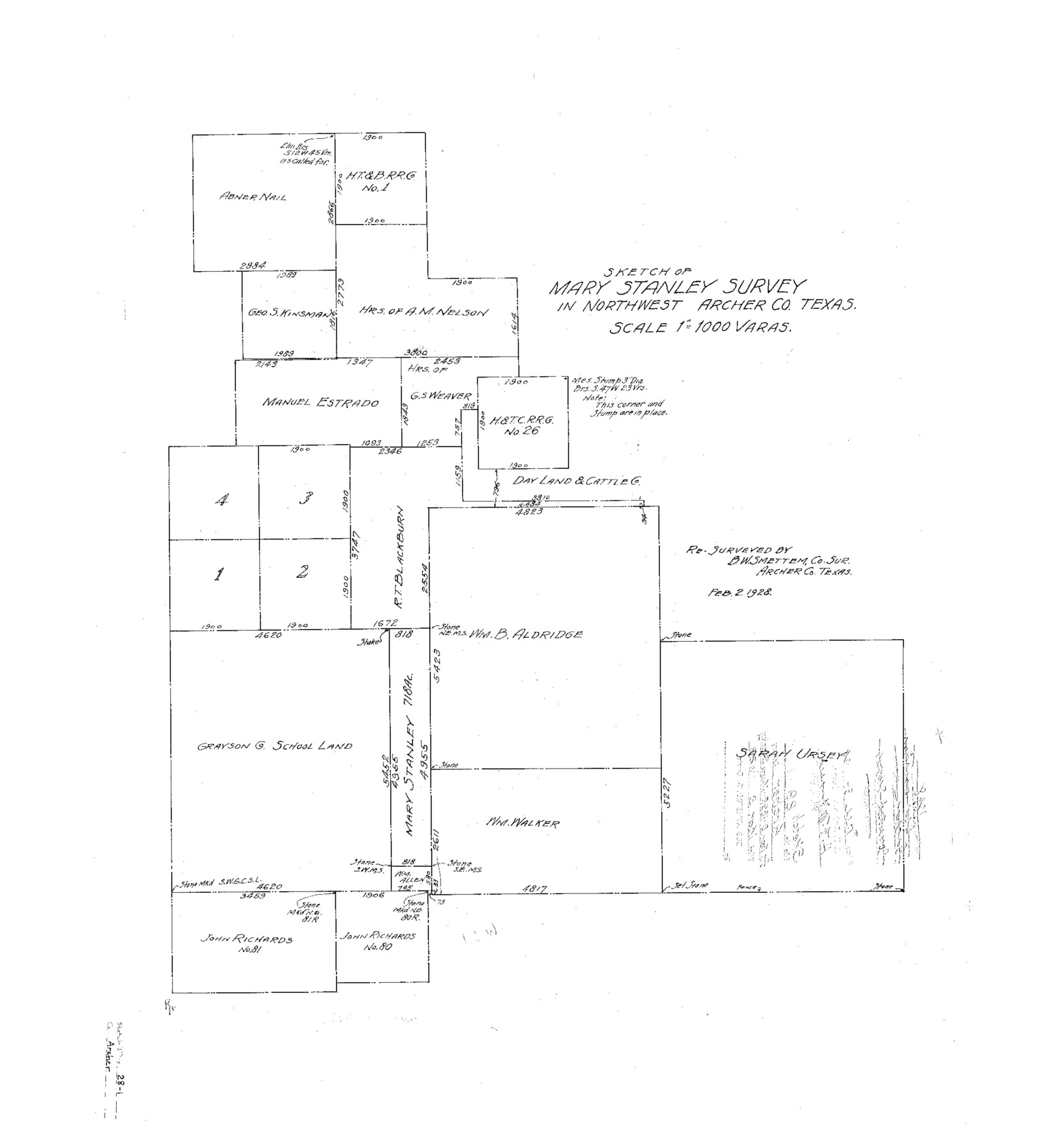
Sketch of Mary Stanley survey in northwest Archer Co., Texas
-
Map/Doc
10834
-
Collection
General Map Collection
-
Object Dates
1928/3/3 (File Date)
1928/2/2 (Creation Date)
-
People and Organizations
B.W. Smettem (Surveyor/Engineer)
-
Counties
Archer
-
Subjects
Surveying Sketch File
-
Height x Width
23.8 x 22.0 inches
60.5 x 55.9 cm
-
Medium
blueprint/diazo
-
Scale
1" = 1000 varas
-
Comments
Sketch transferred from Fannin B-1898.
Part of: General Map Collection
Coryell County Sketch File 3

Print $4.00
- Digital $50.00
Coryell County Sketch File 3
1852
Size 8.3 x 10.1 inches
Map/Doc 19340
Brazoria County Rolled Sketch 20

Print $20.00
- Digital $50.00
Brazoria County Rolled Sketch 20
1917
Size 31.1 x 47.1 inches
Map/Doc 8929
Map of Hale County

Print $40.00
- Digital $50.00
Map of Hale County
1900
Size 49.3 x 41.0 inches
Map/Doc 4691
Travis County Appraisal District Plat Map 3_0104

Print $20.00
- Digital $50.00
Travis County Appraisal District Plat Map 3_0104
Size 21.5 x 26.4 inches
Map/Doc 94224
Kimble County Working Sketch 53

Print $20.00
- Digital $50.00
Kimble County Working Sketch 53
1953
Size 24.5 x 35.9 inches
Map/Doc 70121
Rains County Working Sketch 2

Print $20.00
- Digital $50.00
Rains County Working Sketch 2
Size 14.0 x 12.2 inches
Map/Doc 71828
Map of Kerr County Texas

Print $20.00
- Digital $50.00
Map of Kerr County Texas
1879
Size 20.3 x 28.3 inches
Map/Doc 3763
Map of the River Sabine from its mouth on the Gulf of Mexico in the sea to Logan's Ferry in latitude 31° 58' 24" north

Print $20.00
- Digital $50.00
Map of the River Sabine from its mouth on the Gulf of Mexico in the sea to Logan's Ferry in latitude 31° 58' 24" north
1842
Size 18.3 x 9.3 inches
Map/Doc 65383
Bandera County Working Sketch 1

Print $2.00
- Digital $50.00
Bandera County Working Sketch 1
Size 8.5 x 10.1 inches
Map/Doc 67594
Plat showing proposed counties to be taken from Zapata, Starr & Hidalgo Counties

Print $20.00
- Digital $50.00
Plat showing proposed counties to be taken from Zapata, Starr & Hidalgo Counties
1911
Size 24.8 x 27.8 inches
Map/Doc 2660
Andrews County Sketch File 12

Print $8.00
- Digital $50.00
Andrews County Sketch File 12
1963
Size 11.1 x 8.5 inches
Map/Doc 12857

You may also like
Houston County Sketch File 7a

Print $4.00
- Digital $50.00
Houston County Sketch File 7a
Size 7.6 x 8.2 inches
Map/Doc 26766

Voyages Autour du Monde, et vers les deux poles par terre et par mer - Tome Premier

Voyages Autour du Monde, et vers les deux poles par terre et par mer - Tome Premier
1782
Map/Doc 97085
Andrews County Working Sketch 17

Print $20.00
- Digital $50.00
Andrews County Working Sketch 17
1963
Size 30.7 x 27.1 inches
Map/Doc 67063
Guadalupe County

Print $20.00
- Digital $50.00
Guadalupe County
1877
Size 21.5 x 21.4 inches
Map/Doc 3608
Hill County Sketch File 6

Print $4.00
- Digital $50.00
Hill County Sketch File 6
1848
Size 13.9 x 8.7 inches
Map/Doc 26470
[Del Rio, Texas]
![2070, [Del Rio, Texas], General Map Collection](https://historictexasmaps.com/wmedia_w700/maps/2070-1.tif.jpg)
Print $20.00
- Digital $50.00
[Del Rio, Texas]
1886
Size 24.2 x 34.3 inches
Map/Doc 2070
[Nueces Bay Islands and Nesting Birds]
![2084, [Nueces Bay Islands and Nesting Birds], General Map Collection](https://historictexasmaps.com/wmedia_w700/maps/2084.tif.jpg)
Print $20.00
- Digital $50.00
[Nueces Bay Islands and Nesting Birds]
1940
Size 18.1 x 24.2 inches
Map/Doc 2084
Brazoria County Sketch File 15

Print $4.00
- Digital $50.00
Brazoria County Sketch File 15
1892
Size 12.8 x 8.4 inches
Map/Doc 14977
[C. C. Slaughter Block 1, T. T. RR. Co. Block 2]
![90621, [C. C. Slaughter Block 1, T. T. RR. Co. Block 2], Twichell Survey Records](https://historictexasmaps.com/wmedia_w700/maps/90621-1.tif.jpg)
Print $2.00
- Digital $50.00
[C. C. Slaughter Block 1, T. T. RR. Co. Block 2]
Size 8.6 x 11.5 inches
Map/Doc 90621
Pecos County Rolled Sketch 186

Print $20.00
- Digital $50.00
Pecos County Rolled Sketch 186
1985
Size 39.3 x 27.5 inches
Map/Doc 7305
Oldham County

Print $40.00
- Digital $50.00
Oldham County
1925
Size 42.6 x 51.5 inches
Map/Doc 77387