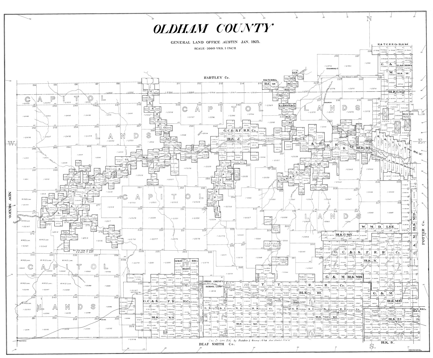
Oldham County
- 
                          Map/Doc77387
- 
                            CollectionGeneral Map Collection
- 
                            Object Dates1925 (Creation Date)
- 
                            CountiesOldham
- 
                            SubjectsCounty
- 
                            Height x Width42.6 x 51.5 inches108.2 x 130.8 cm
Part of: General Map Collection
            San Jacinto County Boundary File 1


                                            Print $6.00                    
                                             -                         Digital $50.00                                    
                San Jacinto County Boundary File 1
Size 9.6 x 8.4 inches
                                Map/Doc 58548
            
            Mustang Island, Nueces County, Texas


                                            Print $20.00                    
                                             -                         Digital $50.00                                    
                Mustang Island, Nueces County, Texas
1978
Size 40.7 x 36.2 inches
                                Map/Doc 2500
            
            Lynn County Rolled Sketch 3


                                            Print $20.00                    
                                             -                         Digital $50.00                                    
                Lynn County Rolled Sketch 3
Size 27.3 x 29.9 inches
                                Map/Doc 6644
            
            Frio County Sketch File 22


                                            Print $10.00                    
                                             -                         Digital $50.00                                    
                Frio County Sketch File 22
1994
Size 11.4 x 8.6 inches
                                Map/Doc 23162
            
            Palo Pinto County Working Sketch 7


                                            Print $20.00                    
                                             -                         Digital $50.00                                    
                Palo Pinto County Working Sketch 7
1922
Map/Doc 71390
            
            Houston County Working Sketch 3


                                            Print $20.00                    
                                             -                         Digital $50.00                                    
                Houston County Working Sketch 3
Size 16.7 x 18.5 inches
                                Map/Doc 66233
            
            Pecos County Rolled Sketch 39


                                            Print $20.00                    
                                             -                         Digital $50.00                                    
                Pecos County Rolled Sketch 39
1908
Size 21.8 x 33.2 inches
                                Map/Doc 7217
            
            Presidio County Working Sketch 88


                                            Print $20.00                    
                                             -                         Digital $50.00                                    
                Presidio County Working Sketch 88
1971
Size 46.9 x 37.7 inches
                                Map/Doc 71765
            
            Newton County Rolled Sketch 6A


                                                                    Digital $50.00                                    
                Newton County Rolled Sketch 6A
Size 10.3 x 15.4 inches
                                Map/Doc 46838
            
            Flight Mission No. DQN-1K, Frame 131, Calhoun County


                                            Print $20.00                    
                                             -                         Digital $50.00                                    
                Flight Mission No. DQN-1K, Frame 131, Calhoun County
1953
Size 18.6 x 22.4 inches
                                Map/Doc 84194
            
            Flight Mission No. CUG-1P, Frame 84, Kleberg County


                                            Print $20.00                    
                                             -                         Digital $50.00                                    
                Flight Mission No. CUG-1P, Frame 84, Kleberg County
1956
Size 18.4 x 22.3 inches
                                Map/Doc 86149
            You may also like
            [Blocks T1, T2, T3, and Vicinity]
            
                                    ![90983, [Blocks T1, T2, T3, and Vicinity], Twichell Survey Records](https://historictexasmaps.com/wmedia_w700/maps/90983-1.tif.jpg) 


    ![90983, [Blocks T1, T2, T3, and Vicinity], Twichell Survey Records](https://historictexasmaps.com/wmedia_w700/maps/90983-1.tif.jpg) 
                                
            
                                            Print $20.00                    
                                             -                         Digital $50.00                                    
                [Blocks T1, T2, T3, and Vicinity]
Size 30.3 x 33.6 inches
                                Map/Doc 90983
            
            Zavala County Boundary File 4


                                            Print $42.00                    
                                             -                         Digital $50.00                                    
                Zavala County Boundary File 4
Size 9.2 x 7.9 inches
                                Map/Doc 60271
            
            Hopkins County Sketch File 21


                                            Print $24.00                    
                                             -                         Digital $50.00                                    
                Hopkins County Sketch File 21
1871
Size 8.1 x 12.5 inches
                                Map/Doc 26727
            
            Hansford County Boundary File 1a


                                            Print $2.00                    
                                             -                         Digital $50.00                                    
                Hansford County Boundary File 1a
Size 11.2 x 8.8 inches
                                Map/Doc 54244
            
            Floyd County Sketch File 21


                                            Print $20.00                    
                                             -                         Digital $50.00                                    
                Floyd County Sketch File 21
1914
Size 30.0 x 23.2 inches
                                Map/Doc 11486
            
            Wilson County Working Sketch 14


                                            Print $20.00                    
                                             -                         Digital $50.00                                    
                Wilson County Working Sketch 14
1987
Size 31.9 x 36.2 inches
                                Map/Doc 72594
            
            Llano County Sketch File 5


                                            Print $4.00                    
                                             -                         Digital $50.00                                    
                Llano County Sketch File 5
Size 12.7 x 8.2 inches
                                Map/Doc 30356
            
            Flight Mission No. DCL-6C, Frame 175, Kenedy County


                                            Print $20.00                    
                                             -                         Digital $50.00                                    
                Flight Mission No. DCL-6C, Frame 175, Kenedy County
1943
Size 18.6 x 22.3 inches
                                Map/Doc 85987
            
            Runnels County Rolled Sketch 30


                                            Print $20.00                    
                                             -                         Digital $50.00                                    
                Runnels County Rolled Sketch 30
Size 26.8 x 30.6 inches
                                Map/Doc 7518
            
            [Leagues 53 through 57]
            
                                    ![92483, [Leagues 53 through 57], Twichell Survey Records](https://historictexasmaps.com/wmedia_w700/maps/92483-1.tif.jpg) 


    ![92483, [Leagues 53 through 57], Twichell Survey Records](https://historictexasmaps.com/wmedia_w700/maps/92483-1.tif.jpg) 
                                
            
                                            Print $20.00                    
                                             -                         Digital $50.00                                    
                [Leagues 53 through 57]
1913
Size 17.8 x 19.0 inches
                                Map/Doc 92483
            
            Flight Mission No. CRC-4R, Frame 99, Chambers County


                                            Print $20.00                    
                                             -                         Digital $50.00                                    
                Flight Mission No. CRC-4R, Frame 99, Chambers County
1956
Size 18.5 x 22.2 inches
                                Map/Doc 84896
            
            Louisiana and Texas Intracoastal Waterway - Matagorda-Espiritu Santo and San Antonio Bays, Section 8-9, Survey of 1927-8 - Index Sheet 3


                                            Print $20.00                    
                                             -                         Digital $50.00                                    
                Louisiana and Texas Intracoastal Waterway - Matagorda-Espiritu Santo and San Antonio Bays, Section 8-9, Survey of 1927-8 - Index Sheet 3
1929
Size 31.0 x 42.8 inches
                                Map/Doc 61837
             
                        