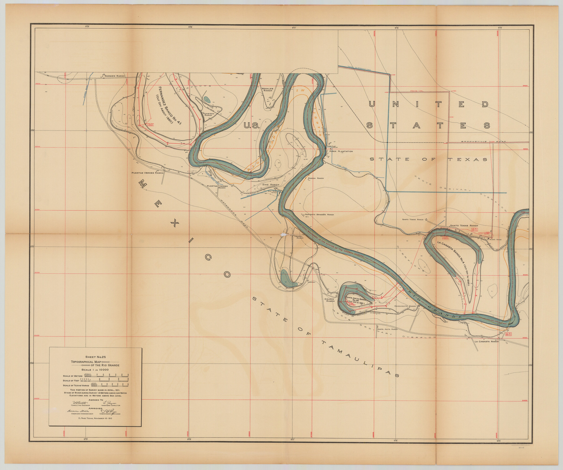
Topographical Map of the Rio Grande, Sheet No. 25
[from book: "Survey of the Rio Grande, Roma to the Gulf of Mexico, Reports and Maps"]
-
Map/Doc
89549
-
Collection
General Map Collection
-
Object Dates
1912/11/16 (Creation Date)
-
People and Organizations
International Boundary Commission (Publisher)
Anson Mills (Author)
E. Zayas (Surveyor/Engineer)
F.B. Puga (Author)
W.W. Follett (Surveyor/Engineer)
-
Subjects
River Surveys Texas Boundaries Topographic
-
Medium
paper
-
Scale
1:10000
-
Comments
This portion of the survey made in April, 1911. State of river during survey 1.5 meters above low water. Elevations are in meters above sea level. This map and 31 others were originally folded and bound into a book titled "Survey of the Rio Grande, R
Part of: General Map Collection
Travis County Boundary File 2

Print $42.00
- Digital $50.00
Travis County Boundary File 2
Size 9.3 x 7.2 inches
Map/Doc 59406
Flight Mission No. BRE-1P, Frame 115, Nueces County

Print $20.00
- Digital $50.00
Flight Mission No. BRE-1P, Frame 115, Nueces County
1956
Size 18.4 x 22.2 inches
Map/Doc 86681
Chambers County Working Sketch 21

Print $20.00
- Digital $50.00
Chambers County Working Sketch 21
1974
Size 44.1 x 34.8 inches
Map/Doc 68004
Upshur County Sketch File 13A

Print $20.00
- Digital $50.00
Upshur County Sketch File 13A
1936
Size 20.5 x 32.4 inches
Map/Doc 12503
Zavala County Sketch File 12

Print $54.00
- Digital $50.00
Zavala County Sketch File 12
1886
Size 9.0 x 7.7 inches
Map/Doc 41279
Roberts County Sketch File 7

Print $16.00
- Digital $50.00
Roberts County Sketch File 7
1992
Size 14.3 x 8.8 inches
Map/Doc 35316
Willacy County Aerial Photograph Index Sheet 5

Print $20.00
- Digital $50.00
Willacy County Aerial Photograph Index Sheet 5
1940
Size 20.1 x 24.4 inches
Map/Doc 83758
Flight Mission No. DCL-6C, Frame 134, Kenedy County

Print $20.00
- Digital $50.00
Flight Mission No. DCL-6C, Frame 134, Kenedy County
1943
Size 18.5 x 22.2 inches
Map/Doc 85964
Flight Mission No. CRK-8P, Frame 117, Refugio County

Print $20.00
- Digital $50.00
Flight Mission No. CRK-8P, Frame 117, Refugio County
1956
Size 18.1 x 22.0 inches
Map/Doc 86972
Jackson County Sketch File 6a

Print $30.00
- Digital $50.00
Jackson County Sketch File 6a
1894
Size 13.6 x 8.8 inches
Map/Doc 27634
Newton County

Print $40.00
- Digital $50.00
Newton County
1946
Size 48.7 x 42.6 inches
Map/Doc 73250
Colorado County Working Sketch 28

Print $20.00
- Digital $50.00
Colorado County Working Sketch 28
1979
Size 33.5 x 24.3 inches
Map/Doc 68128
You may also like
Shelby County Sketch File 2

Print $4.00
- Digital $50.00
Shelby County Sketch File 2
1849
Size 12.6 x 7.6 inches
Map/Doc 36593
Karnes County Sketch File 7

Print $10.00
- Digital $50.00
Karnes County Sketch File 7
1863
Size 10.6 x 8.2 inches
Map/Doc 28559
Hutchinson County Sketch File 4a

Print $7.00
- Digital $50.00
Hutchinson County Sketch File 4a
Size 25.9 x 43.8 inches
Map/Doc 10625
Brazoria County NRC Article 33.136 Sketch 30

Print $24.00
Brazoria County NRC Article 33.136 Sketch 30
2025
Map/Doc 97475
Navarro County Sketch File 17

Print $4.00
- Digital $50.00
Navarro County Sketch File 17
Size 12.8 x 8.4 inches
Map/Doc 32333
Scurry County Rolled Sketch 8

Print $20.00
- Digital $50.00
Scurry County Rolled Sketch 8
1949
Size 35.1 x 19.1 inches
Map/Doc 7768
The Mexican Municipality of Mina. ca. Spring 1835

Print $20.00
The Mexican Municipality of Mina. ca. Spring 1835
2020
Size 10.7 x 21.8 inches
Map/Doc 96029
Orange County Sketch File 38

Print $6.00
- Digital $50.00
Orange County Sketch File 38
1954
Size 14.3 x 8.7 inches
Map/Doc 33378
Van Zandt County Sketch File 34

Print $4.00
- Digital $50.00
Van Zandt County Sketch File 34
1861
Size 7.8 x 15.0 inches
Map/Doc 39472
Jim Hogg County

Print $20.00
- Digital $50.00
Jim Hogg County
1962
Size 40.3 x 28.5 inches
Map/Doc 77330
Amistad International Reservoir on Rio Grande 95

Print $20.00
- Digital $50.00
Amistad International Reservoir on Rio Grande 95
1950
Size 28.5 x 40.1 inches
Map/Doc 75525
Leon County Sketch File 35-1

Print $28.00
- Digital $50.00
Leon County Sketch File 35-1
1966
Size 14.1 x 8.6 inches
Map/Doc 29836