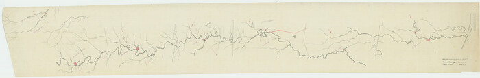
[Traverse up the Brazos and Colorado River showing distance from county site to county site]
Print $40.00
- Digital $50.00
[Traverse up the Brazos and Colorado River showing distance from county site to county site]
1871
Size: 16.2 x 98.8 inches
2054
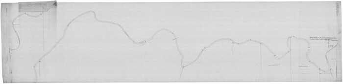
[Plat of Colorado River Survey, McCulloch County]
Print $40.00
- Digital $50.00
[Plat of Colorado River Survey, McCulloch County]
1918
Size: 40.3 x 159.2 inches
2462
Plat of South 1/2 of Colorado River Channel in McCulloch Co., Texas from Concho County line down river 34 mile 315 varas

Print $40.00
- Digital $50.00
Plat of South 1/2 of Colorado River Channel in McCulloch Co., Texas from Concho County line down river 34 mile 315 varas
1918
Size: 41.5 x 104.6 inches
2463
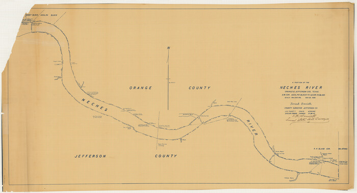
Map of Neches River, Texas from Sabine Lake to Beaumont, Texas

Print $40.00
- Digital $50.00
Map of Neches River, Texas from Sabine Lake to Beaumont, Texas
1910
Size: 32.4 x 104.0 inches
2465
[Neches River Bed, Plat and Calculations]
Print $40.00
- Digital $50.00
[Neches River Bed, Plat and Calculations]
1928
Size: 27.3 x 51.0 inches
2466
Topographic Map, Reynard Sheet, Trinity River; Houston and Leon Counties

Print $20.00
- Digital $50.00
Topographic Map, Reynard Sheet, Trinity River; Houston and Leon Counties
1925
Size: 45.6 x 41.4 inches
2469
Soil Map - Ohio-Michigan, Toledo Set

Print $20.00
- Digital $50.00
Soil Map - Ohio-Michigan, Toledo Set
1902
Size: 21.4 x 30.5 inches
3023
General Land Office and State Reclamation Department - An Index Map

Print $20.00
- Digital $50.00
General Land Office and State Reclamation Department - An Index Map
1930
Size: 25.8 x 16.4 inches
3027
San Jacinto River and Tributaries, Texas - Survey of 1939

Print $20.00
- Digital $50.00
San Jacinto River and Tributaries, Texas - Survey of 1939
1939
Size: 28.1 x 40.5 inches
3153
Topography and water depth as shown by the U.S. Coast Survey of 1888

Print $20.00
- Digital $50.00
Topography and water depth as shown by the U.S. Coast Survey of 1888
1890
Size: 17.0 x 18.8 inches
390
Terlingua Special Map, The University of Texas Mineral Survey, Brewster County, Texas

Print $20.00
- Digital $50.00
Terlingua Special Map, The University of Texas Mineral Survey, Brewster County, Texas
1902
Size: 20.4 x 22.6 inches
482
Fort Bend County Rolled Sketch T

Print $20.00
- Digital $50.00
Fort Bend County Rolled Sketch T
1930
Size: 28.7 x 25.8 inches
5908
San Jacinto River and Tributaries, Texas - Survey of 1939

Print $20.00
- Digital $50.00
San Jacinto River and Tributaries, Texas - Survey of 1939
1939
Size: 28.0 x 40.3 inches
60305
San Jacinto River and Tributaries, Texas - Survey of 1939

Print $20.00
- Digital $50.00
San Jacinto River and Tributaries, Texas - Survey of 1939
1939
Size: 27.7 x 40.4 inches
60306
San Jacinto River and Tributaries, Texas - Survey of 1939

Print $20.00
- Digital $50.00
San Jacinto River and Tributaries, Texas - Survey of 1939
1939
Size: 28.0 x 40.3 inches
60307
San Jacinto River and Tributaries, Texas - Survey of 1939

Print $20.00
- Digital $50.00
San Jacinto River and Tributaries, Texas - Survey of 1939
1939
Size: 27.8 x 40.7 inches
60308
San Jacinto River and Tributaries, Texas - Survey of 1939

Print $20.00
- Digital $50.00
San Jacinto River and Tributaries, Texas - Survey of 1939
1939
Size: 27.7 x 40.4 inches
60309
San Jacinto River and Tributaries, Texas - Survey of 1939

Print $20.00
- Digital $50.00
San Jacinto River and Tributaries, Texas - Survey of 1939
1939
Size: 27.7 x 40.5 inches
60310
Harris County Rolled Sketch T1

Print $20.00
- Digital $50.00
Harris County Rolled Sketch T1
1916
Size: 29.8 x 24.3 inches
6144
Harris County Rolled Sketch T2

Print $20.00
- Digital $50.00
Harris County Rolled Sketch T2
1916
Size: 26.8 x 23.2 inches
6145
Galveston Harbor and Channel, Texas Rehabilitation of South Jetty, Comparison of Shorelines and Offshore Contours 1890 to 1960

Print $20.00
- Digital $50.00
Galveston Harbor and Channel, Texas Rehabilitation of South Jetty, Comparison of Shorelines and Offshore Contours 1890 to 1960
1961
Size: 31.6 x 41.8 inches
61827
Jeff Davis County Rolled Sketch 15

Print $20.00
- Digital $50.00
Jeff Davis County Rolled Sketch 15
1897
Size: 20.4 x 17.2 inches
6368
Red River, Kelsey Sheet, Upshur County

Print $4.00
- Digital $50.00
Red River, Kelsey Sheet, Upshur County
1933
Size: 21.1 x 24.2 inches
65056
Red River, Water-Shed of Cypress Creek in Texas Drainage Area

Print $4.00
- Digital $50.00
Red River, Water-Shed of Cypress Creek in Texas Drainage Area
1925
Size: 16.3 x 19.2 inches
65057
Blanco River, Austin Girl Scouts Council

Print $6.00
- Digital $50.00
Blanco River, Austin Girl Scouts Council
1938
Size: 18.5 x 31.6 inches
65058
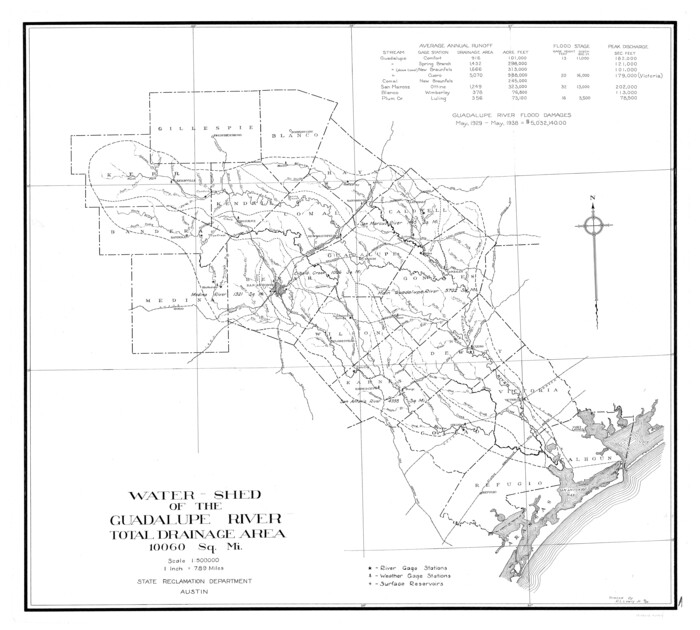
Guadalupe River, Watershed [of the Guadalupe River]
Print $6.00
- Digital $50.00
Guadalupe River, Watershed [of the Guadalupe River]
1925
Size: 30.1 x 33.4 inches
65059
Little River, Faubion Bridge Sheet

Print $4.00
- Digital $50.00
Little River, Faubion Bridge Sheet
1914
Size: 19.0 x 27.8 inches
65060
Little River, Cameron Sheet

Print $4.00
- Digital $50.00
Little River, Cameron Sheet
1914
Size: 28.3 x 24.4 inches
65062
Little River, Holtzclaw Bridge Sheet

Print $4.00
- Digital $50.00
Little River, Holtzclaw Bridge Sheet
1914
Size: 19.7 x 28.8 inches
65063
Little River, Buckholts Sheet

Print $4.00
- Digital $50.00
Little River, Buckholts Sheet
1936
Size: 30.0 x 24.2 inches
65065
[Traverse up the Brazos and Colorado River showing distance from county site to county site]
Print $40.00
- Digital $50.00
[Traverse up the Brazos and Colorado River showing distance from county site to county site]
1871
-
Size
16.2 x 98.8 inches
-
Map/Doc
2054
-
Creation Date
1871
[Plat of Colorado River Survey, McCulloch County]
Print $40.00
- Digital $50.00
[Plat of Colorado River Survey, McCulloch County]
1918
-
Size
40.3 x 159.2 inches
-
Map/Doc
2462
-
Creation Date
1918
Plat of South 1/2 of Colorado River Channel in McCulloch Co., Texas from Concho County line down river 34 mile 315 varas
Print $40.00
- Digital $50.00
Plat of South 1/2 of Colorado River Channel in McCulloch Co., Texas from Concho County line down river 34 mile 315 varas
1918
-
Size
41.5 x 104.6 inches
-
Map/Doc
2463
-
Creation Date
1918
Map of Neches River, Texas from Sabine Lake to Beaumont, Texas
Print $40.00
- Digital $50.00
Map of Neches River, Texas from Sabine Lake to Beaumont, Texas
1910
-
Size
32.4 x 104.0 inches
-
Map/Doc
2465
-
Creation Date
1910
[Neches River Bed, Plat and Calculations]
Print $40.00
- Digital $50.00
[Neches River Bed, Plat and Calculations]
1928
-
Size
27.3 x 51.0 inches
-
Map/Doc
2466
-
Creation Date
1928
Topographic Map, Reynard Sheet, Trinity River; Houston and Leon Counties
Print $20.00
- Digital $50.00
Topographic Map, Reynard Sheet, Trinity River; Houston and Leon Counties
1925
-
Size
45.6 x 41.4 inches
-
Map/Doc
2469
-
Creation Date
1925
Soil Map - Ohio-Michigan, Toledo Set
Print $20.00
- Digital $50.00
Soil Map - Ohio-Michigan, Toledo Set
1902
-
Size
21.4 x 30.5 inches
-
Map/Doc
3023
-
Creation Date
1902
General Land Office and State Reclamation Department - An Index Map
Print $20.00
- Digital $50.00
General Land Office and State Reclamation Department - An Index Map
1930
-
Size
25.8 x 16.4 inches
-
Map/Doc
3027
-
Creation Date
1930
San Jacinto River and Tributaries, Texas - Survey of 1939
Print $20.00
- Digital $50.00
San Jacinto River and Tributaries, Texas - Survey of 1939
1939
-
Size
28.1 x 40.5 inches
-
Map/Doc
3153
-
Creation Date
1939
Topography and water depth as shown by the U.S. Coast Survey of 1888
Print $20.00
- Digital $50.00
Topography and water depth as shown by the U.S. Coast Survey of 1888
1890
-
Size
17.0 x 18.8 inches
-
Map/Doc
390
-
Creation Date
1890
Terlingua Special Map, The University of Texas Mineral Survey, Brewster County, Texas
Print $20.00
- Digital $50.00
Terlingua Special Map, The University of Texas Mineral Survey, Brewster County, Texas
1902
-
Size
20.4 x 22.6 inches
-
Map/Doc
482
-
Creation Date
1902
Fort Bend County Rolled Sketch T
Print $20.00
- Digital $50.00
Fort Bend County Rolled Sketch T
1930
-
Size
28.7 x 25.8 inches
-
Map/Doc
5908
-
Creation Date
1930
San Jacinto River and Tributaries, Texas - Survey of 1939
Print $20.00
- Digital $50.00
San Jacinto River and Tributaries, Texas - Survey of 1939
1939
-
Size
28.0 x 40.3 inches
-
Map/Doc
60305
-
Creation Date
1939
San Jacinto River and Tributaries, Texas - Survey of 1939
Print $20.00
- Digital $50.00
San Jacinto River and Tributaries, Texas - Survey of 1939
1939
-
Size
27.7 x 40.4 inches
-
Map/Doc
60306
-
Creation Date
1939
San Jacinto River and Tributaries, Texas - Survey of 1939
Print $20.00
- Digital $50.00
San Jacinto River and Tributaries, Texas - Survey of 1939
1939
-
Size
28.0 x 40.3 inches
-
Map/Doc
60307
-
Creation Date
1939
San Jacinto River and Tributaries, Texas - Survey of 1939
Print $20.00
- Digital $50.00
San Jacinto River and Tributaries, Texas - Survey of 1939
1939
-
Size
27.8 x 40.7 inches
-
Map/Doc
60308
-
Creation Date
1939
San Jacinto River and Tributaries, Texas - Survey of 1939
Print $20.00
- Digital $50.00
San Jacinto River and Tributaries, Texas - Survey of 1939
1939
-
Size
27.7 x 40.4 inches
-
Map/Doc
60309
-
Creation Date
1939
San Jacinto River and Tributaries, Texas - Survey of 1939
Print $20.00
- Digital $50.00
San Jacinto River and Tributaries, Texas - Survey of 1939
1939
-
Size
27.7 x 40.5 inches
-
Map/Doc
60310
-
Creation Date
1939
Harris County Rolled Sketch T1
Print $20.00
- Digital $50.00
Harris County Rolled Sketch T1
1916
-
Size
29.8 x 24.3 inches
-
Map/Doc
6144
-
Creation Date
1916
Harris County Rolled Sketch T2
Print $20.00
- Digital $50.00
Harris County Rolled Sketch T2
1916
-
Size
26.8 x 23.2 inches
-
Map/Doc
6145
-
Creation Date
1916
Galveston Harbor and Channel, Texas Rehabilitation of South Jetty, Comparison of Shorelines and Offshore Contours 1890 to 1960
Print $20.00
- Digital $50.00
Galveston Harbor and Channel, Texas Rehabilitation of South Jetty, Comparison of Shorelines and Offshore Contours 1890 to 1960
1961
-
Size
31.6 x 41.8 inches
-
Map/Doc
61827
-
Creation Date
1961
Jeff Davis County Rolled Sketch 15
Print $20.00
- Digital $50.00
Jeff Davis County Rolled Sketch 15
1897
-
Size
20.4 x 17.2 inches
-
Map/Doc
6368
-
Creation Date
1897
Red River, Kelsey Sheet, Upshur County
Print $4.00
- Digital $50.00
Red River, Kelsey Sheet, Upshur County
1933
-
Size
21.1 x 24.2 inches
-
Map/Doc
65056
-
Creation Date
1933
Red River, Water-Shed of Cypress Creek in Texas Drainage Area
Print $4.00
- Digital $50.00
Red River, Water-Shed of Cypress Creek in Texas Drainage Area
1925
-
Size
16.3 x 19.2 inches
-
Map/Doc
65057
-
Creation Date
1925
Blanco River, Austin Girl Scouts Council
Print $6.00
- Digital $50.00
Blanco River, Austin Girl Scouts Council
1938
-
Size
18.5 x 31.6 inches
-
Map/Doc
65058
-
Creation Date
1938
Guadalupe River, Watershed [of the Guadalupe River]
Print $6.00
- Digital $50.00
Guadalupe River, Watershed [of the Guadalupe River]
1925
-
Size
30.1 x 33.4 inches
-
Map/Doc
65059
-
Creation Date
1925
Little River, Faubion Bridge Sheet
Print $4.00
- Digital $50.00
Little River, Faubion Bridge Sheet
1914
-
Size
19.0 x 27.8 inches
-
Map/Doc
65060
-
Creation Date
1914
Little River, Cameron Sheet
Print $4.00
- Digital $50.00
Little River, Cameron Sheet
1914
-
Size
28.3 x 24.4 inches
-
Map/Doc
65062
-
Creation Date
1914
Little River, Holtzclaw Bridge Sheet
Print $4.00
- Digital $50.00
Little River, Holtzclaw Bridge Sheet
1914
-
Size
19.7 x 28.8 inches
-
Map/Doc
65063
-
Creation Date
1914
Little River, Buckholts Sheet
Print $4.00
- Digital $50.00
Little River, Buckholts Sheet
1936
-
Size
30.0 x 24.2 inches
-
Map/Doc
65065
-
Creation Date
1936