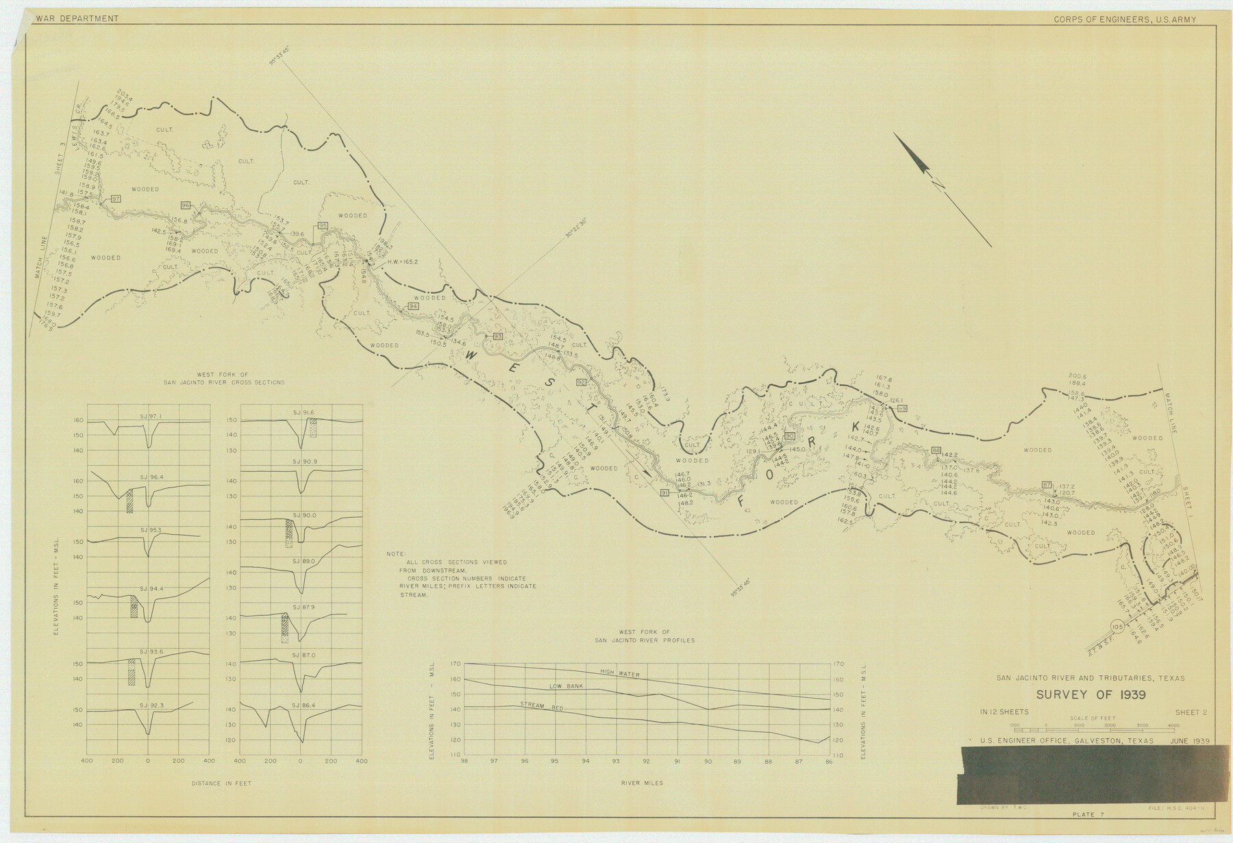
San Jacinto River and Tributaries, Texas - Survey of 1939
N-2-16 (a-g)
-
Map/Doc
60310
-
Collection
General Map Collection
-
Object Dates
1939 (Creation Date)
-
People and Organizations
Corps of Engineers, U. S. Army (Publisher)
Corps of Engineers (Surveyor/Engineer)
-
Subjects
River Surveys Topographic
-
Height x Width
27.7 x 40.5 inches
70.4 x 102.9 cm
Part of: General Map Collection
Blanco County Working Sketch 42

Print $20.00
- Digital $50.00
Blanco County Working Sketch 42
1986
Size 35.1 x 30.7 inches
Map/Doc 67402
Angelina County Sketch File 15g

Print $4.00
- Digital $50.00
Angelina County Sketch File 15g
1882
Size 10.9 x 8.4 inches
Map/Doc 12996
Aransas County Sketch File 21b

Print $4.00
- Digital $50.00
Aransas County Sketch File 21b
Size 8.7 x 14.2 inches
Map/Doc 13160
McCulloch County Sketch File 3

Print $12.00
- Digital $50.00
McCulloch County Sketch File 3
1893
Size 11.1 x 8.5 inches
Map/Doc 31169
[Location Survey of the Southern Kansas Railway, Kiowa Extension from a point in Drake's Location, in Indian Territory 100 miles from south line of Kansas, continuing up Wolf Creek and South Canadian River to Cottonwood Creek in Hutchinson County]
![88840, [Location Survey of the Southern Kansas Railway, Kiowa Extension from a point in Drake's Location, in Indian Territory 100 miles from south line of Kansas, continuing up Wolf Creek and South Canadian River to Cottonwood Creek in Hutchinson County], General Map Collection](https://historictexasmaps.com/wmedia_w700/maps/88840.tif.jpg)
Print $20.00
- Digital $50.00
[Location Survey of the Southern Kansas Railway, Kiowa Extension from a point in Drake's Location, in Indian Territory 100 miles from south line of Kansas, continuing up Wolf Creek and South Canadian River to Cottonwood Creek in Hutchinson County]
1886
Size 39.1 x 38.0 inches
Map/Doc 88840
Atascosa County Sketch File 5

Print $8.00
- Digital $50.00
Atascosa County Sketch File 5
1856
Size 8.2 x 12.4 inches
Map/Doc 13748
Jeff Davis County Sketch File 13

Print $14.00
- Digital $50.00
Jeff Davis County Sketch File 13
1889
Size 13.9 x 8.5 inches
Map/Doc 27941
Gillespie County Boundary File 2

Print $42.00
- Digital $50.00
Gillespie County Boundary File 2
Size 6.7 x 4.0 inches
Map/Doc 53724
Darrington Plantation of the Texas Prison System, Brazoria County

Print $20.00
- Digital $50.00
Darrington Plantation of the Texas Prison System, Brazoria County
Size 16.9 x 37.4 inches
Map/Doc 62986
Pecos County Working Sketch 91a

Print $40.00
- Digital $50.00
Pecos County Working Sketch 91a
1965
Size 78.9 x 32.5 inches
Map/Doc 71563
Uvalde County

Print $20.00
- Digital $50.00
Uvalde County
1915
Size 42.9 x 46.2 inches
Map/Doc 63091
Aransas County Rolled Sketch 27A

Print $2.00
- Digital $50.00
Aransas County Rolled Sketch 27A
1930
Size 8.9 x 7.2 inches
Map/Doc 5058
You may also like
Harris County Sketch File 1

Print $20.00
- Digital $50.00
Harris County Sketch File 1
Size 14.8 x 12.6 inches
Map/Doc 25332
Lynn County Boundary File 8

Print $4.00
- Digital $50.00
Lynn County Boundary File 8
Size 10.4 x 8.6 inches
Map/Doc 56655
Map of Kimble County

Print $20.00
- Digital $50.00
Map of Kimble County
1879
Size 18.7 x 28.9 inches
Map/Doc 3765
Rio Grande, Madero Sheet

Print $20.00
- Digital $50.00
Rio Grande, Madero Sheet
1931
Size 33.0 x 38.5 inches
Map/Doc 65124
Wilbarger County Sketch File 8

Print $4.00
- Digital $50.00
Wilbarger County Sketch File 8
1885
Size 14.2 x 8.6 inches
Map/Doc 40179
Map of the Texas and Pacific Railway and connections

Print $20.00
- Digital $50.00
Map of the Texas and Pacific Railway and connections
1927
Size 8.2 x 9.4 inches
Map/Doc 95773
The Republic County of Refugio. December 29, 1845

Print $20.00
The Republic County of Refugio. December 29, 1845
2020
Size 22.3 x 21.6 inches
Map/Doc 96258
Harris County Rolled Sketch 99

Print $20.00
- Digital $50.00
Harris County Rolled Sketch 99
1985
Size 16.2 x 20.2 inches
Map/Doc 6137
Montague County Sketch File 9

Print $18.00
- Digital $50.00
Montague County Sketch File 9
1872
Size 12.6 x 11.7 inches
Map/Doc 31724
J. B. McCauley Irrigated Farm NW Quarter Section 20, Block E

Print $20.00
- Digital $50.00
J. B. McCauley Irrigated Farm NW Quarter Section 20, Block E
1944
Size 20.5 x 23.0 inches
Map/Doc 92334
Wilbarger County Rolled Sketch 6

Print $20.00
- Digital $50.00
Wilbarger County Rolled Sketch 6
1885
Size 20.3 x 28.0 inches
Map/Doc 8256
Pecos County Working Sketch 99

Print $20.00
- Digital $50.00
Pecos County Working Sketch 99
1970
Size 43.4 x 31.2 inches
Map/Doc 71572