Wilbarger County Rolled Sketch 6
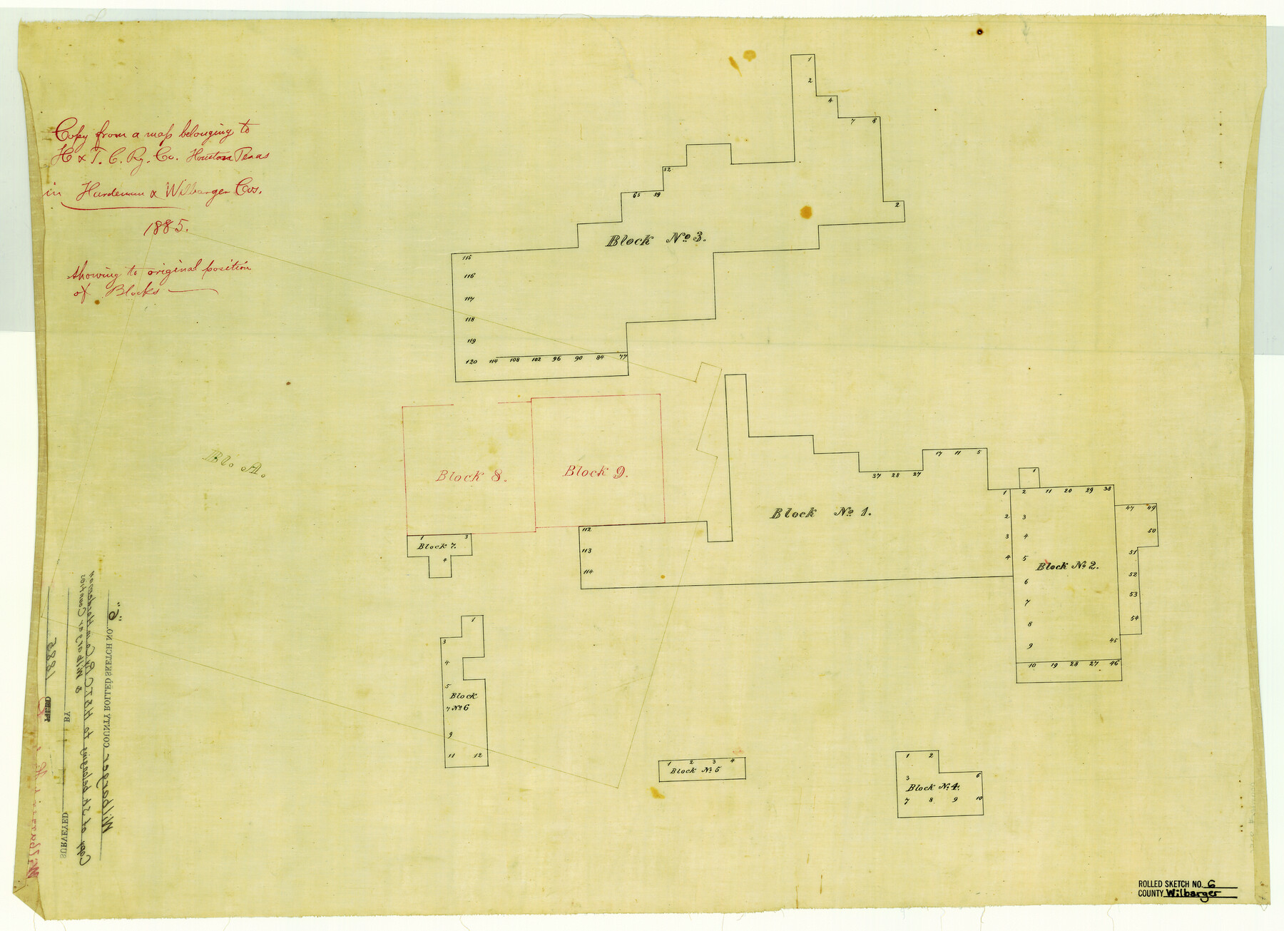
Copy from a map belonging to H. & T. C. Ry. Co., Houston, Texas in Hardeman & Wilbarger Cos.
-
Map/Doc
8256
-
Collection
General Map Collection
-
Object Dates
1885 (Creation Date)
-
Counties
Wilbarger Hardeman
-
Subjects
Surveying Rolled Sketch
-
Height x Width
20.3 x 28.0 inches
51.6 x 71.1 cm
-
Medium
linen, manuscript
Part of: General Map Collection
Hill County Rolled Sketch 1

Print $20.00
- Digital $50.00
Hill County Rolled Sketch 1
1950
Size 13.1 x 41.0 inches
Map/Doc 6214
Plat Showing the Development of Texas Counties from the Original Land Districts

Print $40.00
- Digital $50.00
Plat Showing the Development of Texas Counties from the Original Land Districts
Size 49.1 x 28.1 inches
Map/Doc 75932
Hemphill County Rolled Sketch 2

Print $20.00
- Digital $50.00
Hemphill County Rolled Sketch 2
Size 26.4 x 29.8 inches
Map/Doc 6185

Sutton County Rolled Sketch 70

Print $40.00
- Digital $50.00
Sutton County Rolled Sketch 70
Size 48.7 x 37.0 inches
Map/Doc 9982
McCulloch County Sketch File 11

Print $14.00
- Digital $50.00
McCulloch County Sketch File 11
1929
Size 11.2 x 8.8 inches
Map/Doc 31191
Cooke County Sketch File 25

Print $4.00
- Digital $50.00
Cooke County Sketch File 25
1872
Size 8.2 x 6.8 inches
Map/Doc 19275
Bosque County Working Sketch 26

Print $20.00
- Digital $50.00
Bosque County Working Sketch 26
1995
Size 46.0 x 35.5 inches
Map/Doc 67460
Flight Mission No. BRE-1P, Frame 121, Nueces County

Print $20.00
- Digital $50.00
Flight Mission No. BRE-1P, Frame 121, Nueces County
1956
Size 18.6 x 22.7 inches
Map/Doc 86687
Duval County Working Sketch 46

Print $20.00
- Digital $50.00
Duval County Working Sketch 46
1980
Size 29.4 x 27.2 inches
Map/Doc 68770
Connected Map of Austin's Colony

Print $20.00
- Digital $50.00
Connected Map of Austin's Colony
1892
Size 47.1 x 42.8 inches
Map/Doc 76073
Leon County Working Sketch 48

Print $20.00
- Digital $50.00
Leon County Working Sketch 48
1980
Size 29.2 x 33.7 inches
Map/Doc 70447
You may also like
Brewster County Working Sketch 72

Print $20.00
- Digital $50.00
Brewster County Working Sketch 72
1965
Size 20.7 x 24.6 inches
Map/Doc 67672
Flight Mission No. DAH-9M, Frame 160, Orange County

Print $20.00
- Digital $50.00
Flight Mission No. DAH-9M, Frame 160, Orange County
1953
Size 18.4 x 22.2 inches
Map/Doc 86859

Lee County Working Sketch 22

Print $20.00
- Digital $50.00
Lee County Working Sketch 22
2010
Size 29.2 x 29.6 inches
Map/Doc 89271
Kerr County Rolled Sketch 23

Print $20.00
- Digital $50.00
Kerr County Rolled Sketch 23
1966
Size 39.3 x 27.5 inches
Map/Doc 6503
The Judicial District/County of Burleson. Abolished, Spring 1842

Print $20.00
The Judicial District/County of Burleson. Abolished, Spring 1842
2020
Size 14.1 x 21.7 inches
Map/Doc 96321
Old Miscellaneous File 24

Print $6.00
- Digital $50.00
Old Miscellaneous File 24
1919
Size 14.4 x 8.7 inches
Map/Doc 75629
Map of Stephens County

Print $20.00
- Digital $50.00
Map of Stephens County
1897
Size 42.9 x 38.2 inches
Map/Doc 63044
Harris County NRC Article 33.136 Sketch 15

Print $28.00
- Digital $50.00
Harris County NRC Article 33.136 Sketch 15
2012
Size 24.0 x 18.0 inches
Map/Doc 94762
General Highway Map, Caldwell County, Texas

Print $20.00
General Highway Map, Caldwell County, Texas
1940
Size 18.5 x 25.2 inches
Map/Doc 79034
Presidio County Rolled Sketch S2

Print $20.00
- Digital $50.00
Presidio County Rolled Sketch S2
1916
Size 14.2 x 12.0 inches
Map/Doc 7415
Map of Williamson County

Print $20.00
- Digital $50.00
Map of Williamson County
1876
Size 21.2 x 28.6 inches
Map/Doc 4152