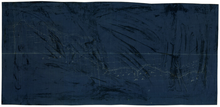
Hardeman County Sketch File 1

Print $20.00
- Digital $50.00
Hardeman County Sketch File 1
Size: 31.0 x 45.7 inches
10477
Hardeman County Rolled Sketch 23

Print $20.00
- Digital $50.00
Hardeman County Rolled Sketch 23
1952
Size: 34.6 x 30.8 inches
10671
[Sketch Showing Surveys on Pease River in Hardeman County, Texas]
Print $20.00
- Digital $50.00
[Sketch Showing Surveys on Pease River in Hardeman County, Texas]
Size: 19.2 x 37.5 inches
10760
Foard County Sketch File 7

Print $3.00
- Digital $50.00
Foard County Sketch File 7
1872
Size: 10.0 x 17.2 inches
11491
Foard County Sketch File 9

Print $20.00
- Digital $50.00
Foard County Sketch File 9
1882
Size: 19.7 x 17.1 inches
11492
Foard County Sketch File 34

Print $20.00
- Digital $50.00
Foard County Sketch File 34
1889
Size: 29.1 x 24.9 inches
11497
Foard County Sketch File 36

Print $20.00
- Digital $50.00
Foard County Sketch File 36
Size: 15.4 x 28.0 inches
11498
Foard County Sketch File X

Print $20.00
- Digital $50.00
Foard County Sketch File X
1882
Size: 15.8 x 17.3 inches
11499
Hardeman County Sketch File 8a

Print $20.00
- Digital $50.00
Hardeman County Sketch File 8a
Size: 16.0 x 32.0 inches
11623
Hardeman County Sketch File 9

Print $20.00
- Digital $50.00
Hardeman County Sketch File 9
1884
Size: 27.7 x 30.1 inches
11624
Hardeman County Sketch File 13

Print $20.00
- Digital $50.00
Hardeman County Sketch File 13
Size: 26.3 x 23.7 inches
11625
Hardeman County Sketch File 14a

Print $20.00
- Digital $50.00
Hardeman County Sketch File 14a
Size: 24.4 x 29.0 inches
11626
Hardeman County Sketch File 15

Print $20.00
- Digital $50.00
Hardeman County Sketch File 15
Size: 18.9 x 17.9 inches
11627
Hardeman County Sketch File 16

Print $20.00
- Digital $50.00
Hardeman County Sketch File 16
Size: 21.9 x 26.8 inches
11628
Hardeman County Sketch File 28

Print $20.00
- Digital $50.00
Hardeman County Sketch File 28
Size: 22.2 x 17.3 inches
11629
Hardeman County Sketch File 30

Print $20.00
- Digital $50.00
Hardeman County Sketch File 30
Size: 26.4 x 27.5 inches
11630
Hardeman County Sketch File A2

Print $20.00
- Digital $50.00
Hardeman County Sketch File A2
Size: 28.5 x 17.3 inches
11631
Knox County Sketch File 7

Print $40.00
- Digital $50.00
Knox County Sketch File 7
1885
Size: 32.2 x 19.9 inches
11955
Wilbarger County Sketch File 24

Print $20.00
- Digital $50.00
Wilbarger County Sketch File 24
1894
Size: 23.3 x 14.9 inches
12691
Hardeman Co[unty]
Print $40.00
- Digital $50.00
Hardeman Co[unty]
1886
Size: 60.7 x 48.8 inches
16845
Childress County Sketch File 16b

Print $6.00
- Digital $50.00
Childress County Sketch File 16b
1884
Size: 12.6 x 8.1 inches
18305
Cottle County Sketch File AA1

Print $95.00
- Digital $50.00
Cottle County Sketch File AA1
1895
Size: 9.4 x 4.2 inches
19398
Cottle County Sketch File G

Print $8.00
- Digital $50.00
Cottle County Sketch File G
Size: 11.5 x 7.3 inches
19447
Map of the Surveyed Part of Young District

Print $40.00
- Digital $50.00
Map of the Surveyed Part of Young District
1860
Size: 56.2 x 54.7 inches
1986
Foard County Sketch File XX

Print $40.00
- Digital $50.00
Foard County Sketch File XX
1884
Size: 14.0 x 16.4 inches
22802
Foard County Sketch File 12

Print $4.00
- Digital $50.00
Foard County Sketch File 12
1881
Size: 11.0 x 8.5 inches
22814
Foard County Sketch File 13

Print $6.00
- Digital $50.00
Foard County Sketch File 13
1885
Size: 13.0 x 8.5 inches
22816
Foard County Sketch File 14

Print $4.00
- Digital $50.00
Foard County Sketch File 14
1885
Size: 14.4 x 8.8 inches
22819
Foard County Sketch File 15

Print $8.00
- Digital $50.00
Foard County Sketch File 15
1883
Size: 13.0 x 8.5 inches
22821
Hardeman County Sketch File 1
Print $20.00
- Digital $50.00
Hardeman County Sketch File 1
-
Size
31.0 x 45.7 inches
-
Map/Doc
10477
Hardeman County Rolled Sketch 23
Print $20.00
- Digital $50.00
Hardeman County Rolled Sketch 23
1952
-
Size
34.6 x 30.8 inches
-
Map/Doc
10671
-
Creation Date
1952
[Sketch Showing Surveys on Pease River in Hardeman County, Texas]
Print $20.00
- Digital $50.00
[Sketch Showing Surveys on Pease River in Hardeman County, Texas]
-
Size
19.2 x 37.5 inches
-
Map/Doc
10760
Foard County Sketch File 7
Print $3.00
- Digital $50.00
Foard County Sketch File 7
1872
-
Size
10.0 x 17.2 inches
-
Map/Doc
11491
-
Creation Date
1872
Foard County Sketch File 9
Print $20.00
- Digital $50.00
Foard County Sketch File 9
1882
-
Size
19.7 x 17.1 inches
-
Map/Doc
11492
-
Creation Date
1882
Foard County Sketch File 34
Print $20.00
- Digital $50.00
Foard County Sketch File 34
1889
-
Size
29.1 x 24.9 inches
-
Map/Doc
11497
-
Creation Date
1889
Foard County Sketch File 36
Print $20.00
- Digital $50.00
Foard County Sketch File 36
-
Size
15.4 x 28.0 inches
-
Map/Doc
11498
Foard County Sketch File X
Print $20.00
- Digital $50.00
Foard County Sketch File X
1882
-
Size
15.8 x 17.3 inches
-
Map/Doc
11499
-
Creation Date
1882
Hardeman County Sketch File 8a
Print $20.00
- Digital $50.00
Hardeman County Sketch File 8a
-
Size
16.0 x 32.0 inches
-
Map/Doc
11623
Hardeman County Sketch File 9
Print $20.00
- Digital $50.00
Hardeman County Sketch File 9
1884
-
Size
27.7 x 30.1 inches
-
Map/Doc
11624
-
Creation Date
1884
Hardeman County Sketch File 13
Print $20.00
- Digital $50.00
Hardeman County Sketch File 13
-
Size
26.3 x 23.7 inches
-
Map/Doc
11625
Hardeman County Sketch File 14a
Print $20.00
- Digital $50.00
Hardeman County Sketch File 14a
-
Size
24.4 x 29.0 inches
-
Map/Doc
11626
Hardeman County Sketch File 15
Print $20.00
- Digital $50.00
Hardeman County Sketch File 15
-
Size
18.9 x 17.9 inches
-
Map/Doc
11627
Hardeman County Sketch File 16
Print $20.00
- Digital $50.00
Hardeman County Sketch File 16
-
Size
21.9 x 26.8 inches
-
Map/Doc
11628
Hardeman County Sketch File 28
Print $20.00
- Digital $50.00
Hardeman County Sketch File 28
-
Size
22.2 x 17.3 inches
-
Map/Doc
11629
Hardeman County Sketch File 30
Print $20.00
- Digital $50.00
Hardeman County Sketch File 30
-
Size
26.4 x 27.5 inches
-
Map/Doc
11630
Hardeman County Sketch File A2
Print $20.00
- Digital $50.00
Hardeman County Sketch File A2
-
Size
28.5 x 17.3 inches
-
Map/Doc
11631
Knox County Sketch File 7
Print $40.00
- Digital $50.00
Knox County Sketch File 7
1885
-
Size
32.2 x 19.9 inches
-
Map/Doc
11955
-
Creation Date
1885
Wilbarger County Sketch File 24
Print $20.00
- Digital $50.00
Wilbarger County Sketch File 24
1894
-
Size
23.3 x 14.9 inches
-
Map/Doc
12691
-
Creation Date
1894
Hardeman Co[unty]
Print $40.00
- Digital $50.00
Hardeman Co[unty]
1886
-
Size
60.7 x 48.8 inches
-
Map/Doc
16845
-
Creation Date
1886
Childress County Sketch File 16b
Print $6.00
- Digital $50.00
Childress County Sketch File 16b
1884
-
Size
12.6 x 8.1 inches
-
Map/Doc
18305
-
Creation Date
1884
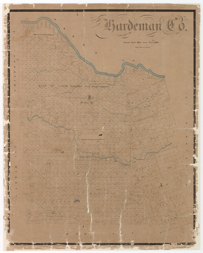
Hardeman County

Print $20.00
- Digital $50.00
Hardeman County
1935
-
Size
45.1 x 42.2 inches
-
Map/Doc
1848
-
Creation Date
1935
Cottle County Sketch File AA1
Print $95.00
- Digital $50.00
Cottle County Sketch File AA1
1895
-
Size
9.4 x 4.2 inches
-
Map/Doc
19398
-
Creation Date
1895
Cottle County Sketch File G
Print $8.00
- Digital $50.00
Cottle County Sketch File G
-
Size
11.5 x 7.3 inches
-
Map/Doc
19447
Map of the Surveyed Part of Young District
Print $40.00
- Digital $50.00
Map of the Surveyed Part of Young District
1860
-
Size
56.2 x 54.7 inches
-
Map/Doc
1986
-
Creation Date
1860
Foard County Sketch File XX
Print $40.00
- Digital $50.00
Foard County Sketch File XX
1884
-
Size
14.0 x 16.4 inches
-
Map/Doc
22802
-
Creation Date
1884
Foard County Sketch File 12
Print $4.00
- Digital $50.00
Foard County Sketch File 12
1881
-
Size
11.0 x 8.5 inches
-
Map/Doc
22814
-
Creation Date
1881
Foard County Sketch File 13
Print $6.00
- Digital $50.00
Foard County Sketch File 13
1885
-
Size
13.0 x 8.5 inches
-
Map/Doc
22816
-
Creation Date
1885
Foard County Sketch File 14
Print $4.00
- Digital $50.00
Foard County Sketch File 14
1885
-
Size
14.4 x 8.8 inches
-
Map/Doc
22819
-
Creation Date
1885
Foard County Sketch File 15
Print $8.00
- Digital $50.00
Foard County Sketch File 15
1883
-
Size
13.0 x 8.5 inches
-
Map/Doc
22821
-
Creation Date
1883