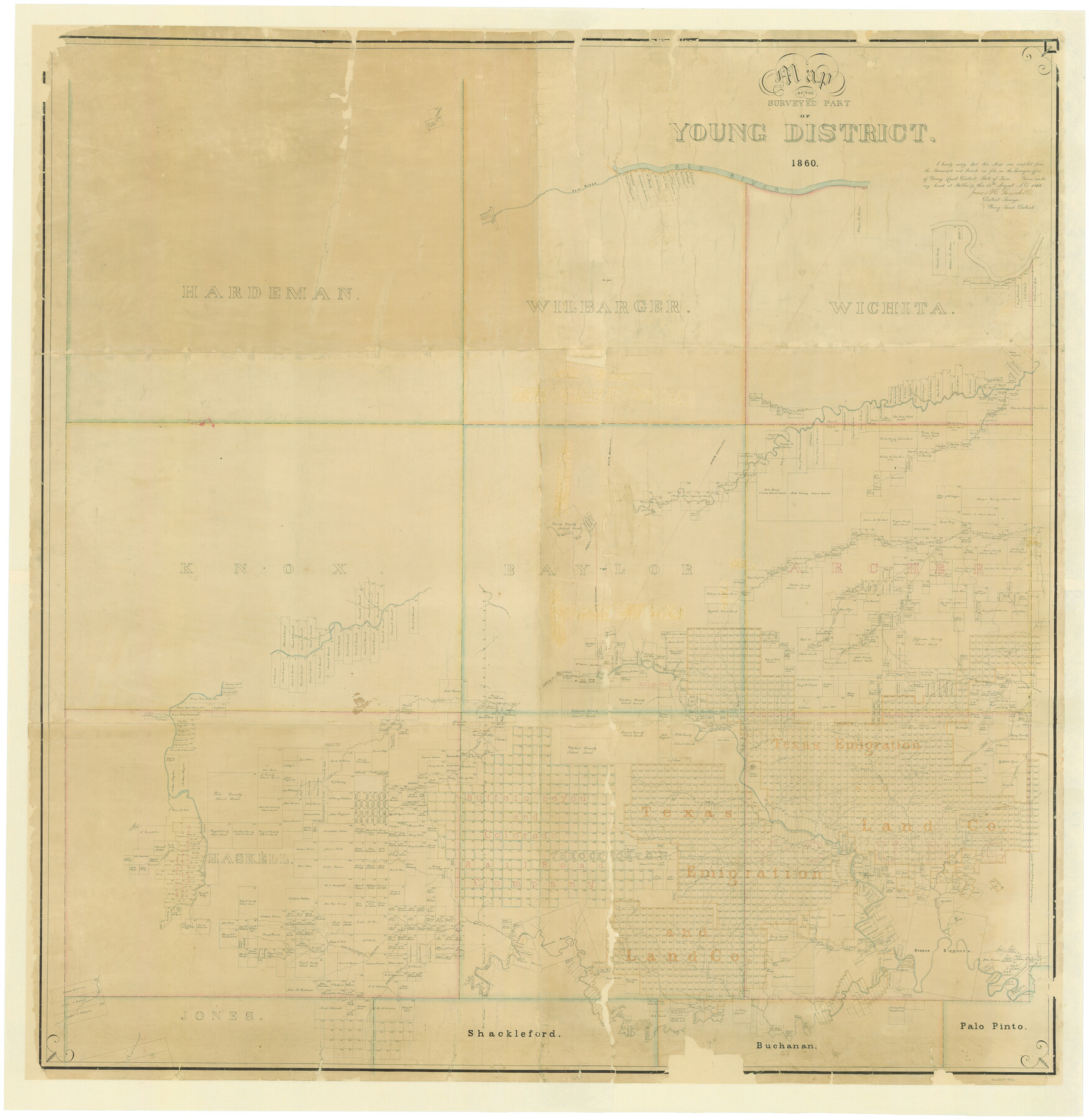
Map of the Surveyed Part of Young District
Z-1-10
-
Map/Doc
1986
-
Collection
General Map Collection
-
Object Dates
8/18/1860 (Creation Date)
-
People and Organizations
James H. Swindells (Surveyor/Engineer)
-
Counties
Hardeman Wilbarger Wichita Knox Baylor Archer
-
Subjects
District
-
Height x Width
56.2 x 54.7 inches
142.8 x 138.9 cm
-
Comments
Digitally combined image. See counters 87373 and 87374 for conserved pieces.
Part of: General Map Collection
Kerr County Working Sketch 12

Print $20.00
- Digital $50.00
Kerr County Working Sketch 12
1951
Size 34.3 x 37.0 inches
Map/Doc 70043
Flight Mission No. DQN-2K, Frame 9, Calhoun County

Print $20.00
- Digital $50.00
Flight Mission No. DQN-2K, Frame 9, Calhoun County
1953
Size 15.7 x 15.6 inches
Map/Doc 84226
Flight Mission No. CRC-3R, Frame 33, Chambers County

Print $20.00
- Digital $50.00
Flight Mission No. CRC-3R, Frame 33, Chambers County
1956
Size 18.6 x 22.4 inches
Map/Doc 84806
Mason County Working Sketch 4

Print $20.00
- Digital $50.00
Mason County Working Sketch 4
1932
Size 16.6 x 22.2 inches
Map/Doc 70840
Travis County Working Sketch 7

Print $2.00
- Digital $50.00
Travis County Working Sketch 7
1913
Size 10.9 x 8.2 inches
Map/Doc 69391
Cuadro Geografico y Estadistico

Print $20.00
- Digital $50.00
Cuadro Geografico y Estadistico
Size 23.1 x 30.9 inches
Map/Doc 96982
San Antonio Bay and Vicinity in Aransas and Calhoun Counties, showing Subdivsion for Mineral Development

Print $40.00
- Digital $50.00
San Antonio Bay and Vicinity in Aransas and Calhoun Counties, showing Subdivsion for Mineral Development
1948
Size 37.0 x 74.5 inches
Map/Doc 1912
Orange County Rolled Sketch 20

Print $40.00
- Digital $50.00
Orange County Rolled Sketch 20
1947
Size 35.2 x 64.3 inches
Map/Doc 9645
Flight Mission No. DQN-6K, Frame 16, Calhoun County

Print $20.00
- Digital $50.00
Flight Mission No. DQN-6K, Frame 16, Calhoun County
1953
Size 18.7 x 22.2 inches
Map/Doc 84438
Flight Mission No. DAG-24K, Frame 46, Matagorda County

Print $20.00
- Digital $50.00
Flight Mission No. DAG-24K, Frame 46, Matagorda County
1953
Size 18.5 x 22.2 inches
Map/Doc 86533
Motley County Sketch File 22 (N)

Print $34.00
- Digital $50.00
Motley County Sketch File 22 (N)
1887
Size 8.2 x 8.4 inches
Map/Doc 32069
Lipscomb County Working Sketch 9

Print $20.00
- Digital $50.00
Lipscomb County Working Sketch 9
1995
Size 44.1 x 22.3 inches
Map/Doc 70585
You may also like
Sabine County

Print $20.00
- Digital $50.00
Sabine County
1920
Size 45.7 x 36.1 inches
Map/Doc 95631
Wilson County Sketch File 3

Print $6.00
- Digital $50.00
Wilson County Sketch File 3
1848
Size 13.3 x 8.6 inches
Map/Doc 40399
General Highway Map. Detail of Cities and Towns in Erath County, Texas

Print $20.00
General Highway Map. Detail of Cities and Towns in Erath County, Texas
1961
Size 18.2 x 24.7 inches
Map/Doc 79461
Fort Bend County Rolled Sketch 3

Print $20.00
- Digital $50.00
Fort Bend County Rolled Sketch 3
1958
Size 31.4 x 31.5 inches
Map/Doc 5893
Current Miscellaneous File 53

Print $8.00
- Digital $50.00
Current Miscellaneous File 53
1945
Size 12.0 x 9.1 inches
Map/Doc 74038
Palo Pinto County

Print $20.00
- Digital $50.00
Palo Pinto County
1896
Size 27.2 x 22.1 inches
Map/Doc 3937

Hopkins County Sketch File 12

Print $6.00
- Digital $50.00
Hopkins County Sketch File 12
Size 6.8 x 8.1 inches
Map/Doc 26706
[Southwest part of County around B. Barrow survey]
![90919, [Southwest part of County around B. Barrow survey], Twichell Survey Records](https://historictexasmaps.com/wmedia_w700/maps/90919-1.tif.jpg)
Print $20.00
- Digital $50.00
[Southwest part of County around B. Barrow survey]
Size 19.6 x 21.1 inches
Map/Doc 90919
Denison, Grayson County, Texas, 1891

Print $20.00
Denison, Grayson County, Texas, 1891
1891
Size 23.9 x 36.4 inches
Map/Doc 93480
Reeves County Working Sketch 12

Print $20.00
- Digital $50.00
Reeves County Working Sketch 12
1958
Size 34.2 x 24.5 inches
Map/Doc 63455
Morris County Rolled Sketch 2A

Print $20.00
- Digital $50.00
Morris County Rolled Sketch 2A
Size 24.2 x 19.1 inches
Map/Doc 10247