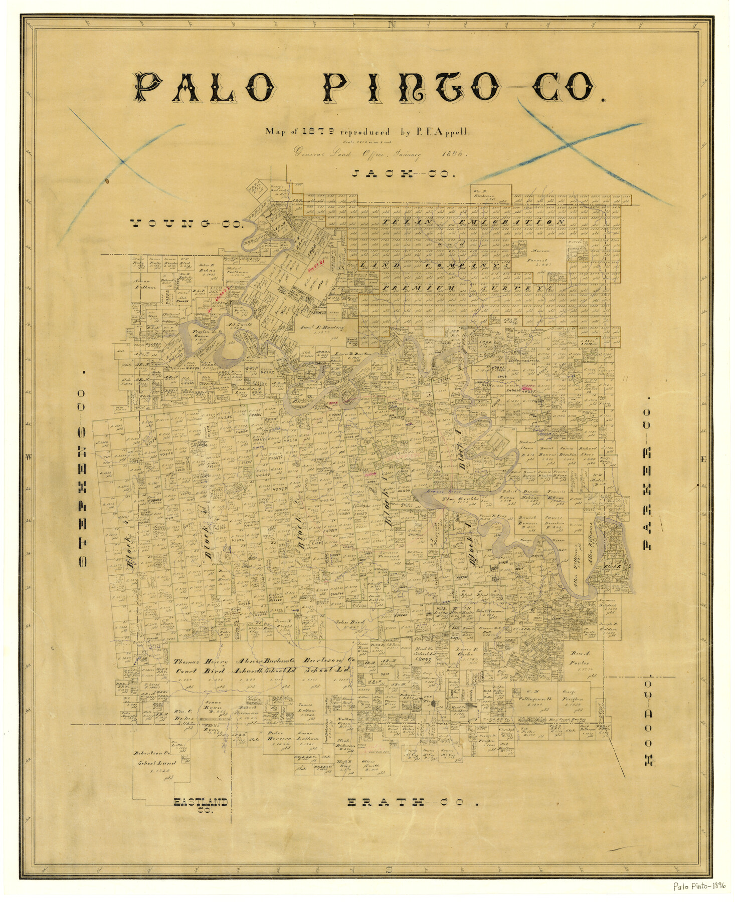
Palo Pinto County
-
Map/Doc
3937
-
Collection
General Map Collection
-
Object Dates
1896 (Creation Date)
-
People and Organizations
Texas General Land Office (Publisher)
P.F. Appell (Draftsman)
-
Counties
Palo Pinto
-
Subjects
County
-
Height x Width
27.2 x 22.1 inches
69.1 x 56.1 cm
-
Comments
Reproduction of map made in 1879.
-
Features
Worser Creek
Sunday Creek
Bartons Creek
Palo Pinto
Cedar Bluff Creek
Buck Creek
South Prong of Palo Pinto Creek
North Prong of Palo Pinto Creek
Walnut Creek
Rock Creek
Palo Pinto Creek
Lake Creek
Ioni Creek
Brazos River
Caddo Creek
Turkey Creek
Keechi Creek
Part of: General Map Collection
Map of the Lands Surveyed by the Memphis, El Paso & Pacific R.R. Company

Print $20.00
- Digital $50.00
Map of the Lands Surveyed by the Memphis, El Paso & Pacific R.R. Company
1860
Size 18.6 x 19.0 inches
Map/Doc 4846
Colorado River, Lane City Sheet

Print $4.00
- Digital $50.00
Colorado River, Lane City Sheet
1941
Size 27.0 x 29.9 inches
Map/Doc 65316

Hudspeth County Working Sketch 26

Print $40.00
- Digital $50.00
Hudspeth County Working Sketch 26
1972
Size 31.5 x 54.0 inches
Map/Doc 66308
Outer Continental Shelf Leasing Maps (Texas Offshore Operations)

Print $20.00
- Digital $50.00
Outer Continental Shelf Leasing Maps (Texas Offshore Operations)
1954
Size 14.7 x 14.2 inches
Map/Doc 75834
Pecos County Boundary File 1a

Print $12.00
- Digital $50.00
Pecos County Boundary File 1a
Size 12.6 x 8.3 inches
Map/Doc 57855
Nueces County

Print $20.00
- Digital $50.00
Nueces County
1913
Size 26.4 x 34.1 inches
Map/Doc 66957
Gregg County Working Sketch 15

Print $20.00
- Digital $50.00
Gregg County Working Sketch 15
1941
Size 24.8 x 29.5 inches
Map/Doc 63282
Midland County

Print $20.00
- Digital $50.00
Midland County
1930
Size 45.7 x 39.6 inches
Map/Doc 66930
Flight Mission No. DQN-2K, Frame 127, Calhoun County

Print $20.00
- Digital $50.00
Flight Mission No. DQN-2K, Frame 127, Calhoun County
1953
Size 18.4 x 22.3 inches
Map/Doc 84301
Jasper County Sketch File 18

Print $32.00
- Digital $50.00
Jasper County Sketch File 18
1890
Size 12.6 x 7.9 inches
Map/Doc 27808
Duval County Sketch File 87

Print $12.00
- Digital $50.00
Duval County Sketch File 87
1991
Size 11.0 x 8.5 inches
Map/Doc 21549
You may also like
Flight Mission No. CRC-3R, Frame 46, Chambers County

Print $20.00
- Digital $50.00
Flight Mission No. CRC-3R, Frame 46, Chambers County
1956
Size 18.6 x 22.5 inches
Map/Doc 84819
Runnels County Boundary File 1a

Print $14.00
- Digital $50.00
Runnels County Boundary File 1a
Size 12.9 x 8.4 inches
Map/Doc 58507
Coast of Texas from Vicinity of Bolivar Point to Rollover Station

Print $40.00
- Digital $50.00
Coast of Texas from Vicinity of Bolivar Point to Rollover Station
1886
Size 32.5 x 54.0 inches
Map/Doc 69920
Midland County

Print $20.00
- Digital $50.00
Midland County
1896
Size 23.0 x 21.1 inches
Map/Doc 3878
Presidio County Sketch File 117

Print $26.00
- Digital $50.00
Presidio County Sketch File 117
1994
Size 14.3 x 8.8 inches
Map/Doc 34906
Presidio County Working Sketch 132

Print $20.00
- Digital $50.00
Presidio County Working Sketch 132
1989
Size 36.7 x 29.4 inches
Map/Doc 71810
[Leagues in Northwest Lamb County]
![91073, [Leagues in Northwest Lamb County], Twichell Survey Records](https://historictexasmaps.com/wmedia_w700/maps/91073-1.tif.jpg)
Print $20.00
- Digital $50.00
[Leagues in Northwest Lamb County]
Size 19.5 x 23.2 inches
Map/Doc 91073
San Jacinto County Working Sketch Graphic Index

Print $20.00
- Digital $50.00
San Jacinto County Working Sketch Graphic Index
1942
Size 44.9 x 40.6 inches
Map/Doc 76691
Map of Colorado County

Print $20.00
- Digital $50.00
Map of Colorado County
1841
Size 27.6 x 36.9 inches
Map/Doc 3422

Jefferson County NRC Article 33.136 Sketch 1

Print $20.00
- Digital $50.00
Jefferson County NRC Article 33.136 Sketch 1
2002
Size 24.0 x 36.1 inches
Map/Doc 61601
Northeast Part of Webb County

Print $40.00
- Digital $50.00
Northeast Part of Webb County
1986
Size 38.0 x 49.2 inches
Map/Doc 73318