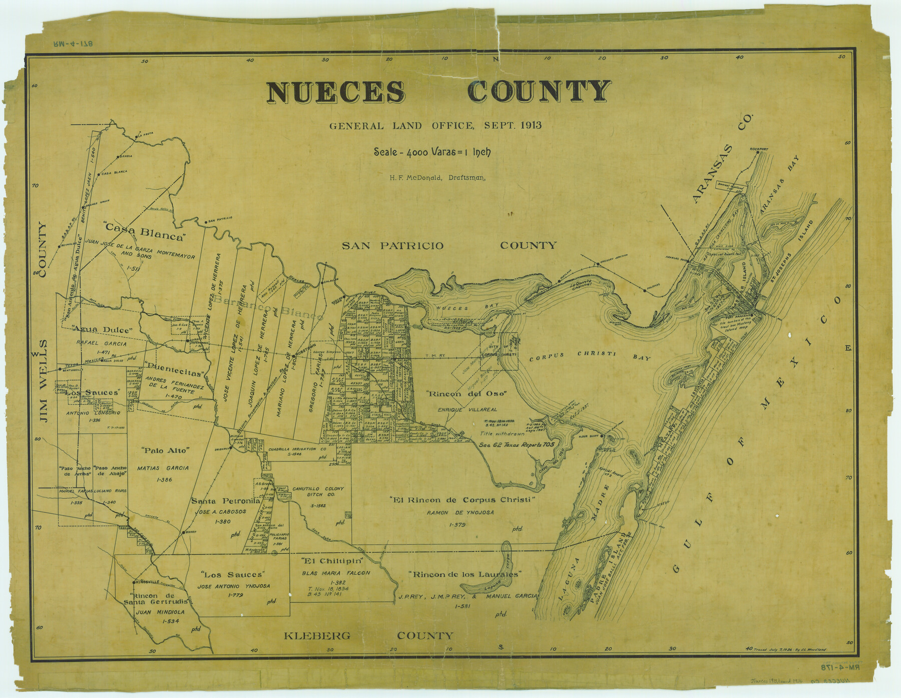
Nueces County
RM-4-178
-
Map/Doc
66957
-
Collection
General Map Collection
-
Object Dates
1913 (Creation Date)
-
People and Organizations
Texas General Land Office (Publisher)
H.F. McDonald (Draftsman)
H.F. McDonald (Compiler)
-
Counties
Nueces
-
Subjects
County
-
Height x Width
26.4 x 34.1 inches
67.1 x 86.6 cm
-
Comments
Traced July 7, 1936 by J. L. Woodland.
Part of: General Map Collection
Lee County Working Sketch 7

Print $20.00
- Digital $50.00
Lee County Working Sketch 7
1977
Size 27.0 x 16.8 inches
Map/Doc 70386
Brewster County Working Sketch 98

Print $20.00
- Digital $50.00
Brewster County Working Sketch 98
1978
Size 44.9 x 28.5 inches
Map/Doc 67698
[Surveys along the Trinity River]
![321, [Surveys along the Trinity River], General Map Collection](https://historictexasmaps.com/wmedia_w700/maps/321.tif.jpg)
Print $2.00
- Digital $50.00
[Surveys along the Trinity River]
Size 3.6 x 3.7 inches
Map/Doc 321
Brooks County Sketch File 3a

Print $5.00
- Digital $50.00
Brooks County Sketch File 3a
Size 14.2 x 9.5 inches
Map/Doc 16542
Land Titles Issued in Stephen F. Austin's Colony

Print $20.00
Land Titles Issued in Stephen F. Austin's Colony
2015
Size 30.0 x 24.0 inches
Map/Doc 93754
Haskell County Rolled Sketch 14

Print $3.00
- Digital $50.00
Haskell County Rolled Sketch 14
1991
Size 11.1 x 17.1 inches
Map/Doc 6172
Clay County Boundary File 15

Print $8.00
- Digital $50.00
Clay County Boundary File 15
Size 13.3 x 8.2 inches
Map/Doc 51418
Rains County Working Sketch 8

Print $20.00
- Digital $50.00
Rains County Working Sketch 8
1965
Size 24.3 x 28.1 inches
Map/Doc 71834
Freestone County

Print $20.00
- Digital $50.00
Freestone County
1918
Size 46.8 x 39.8 inches
Map/Doc 4702
Val Verde County Sketch File 40

Print $20.00
- Digital $50.00
Val Verde County Sketch File 40
1939
Size 15.3 x 25.5 inches
Map/Doc 12582
Panola County Working Sketch 4

Print $20.00
- Digital $50.00
Panola County Working Sketch 4
1938
Map/Doc 71413
Part of the boundary between the United States and Texas: north of Sabine River from the 36th to the 72nd mile mound (B.2)

Print $2.00
- Digital $50.00
Part of the boundary between the United States and Texas: north of Sabine River from the 36th to the 72nd mile mound (B.2)
1842
Size 12.7 x 8.9 inches
Map/Doc 65386
You may also like
University Lands Blocks 34 to 37, Terrell County, Isogonic Chart & Meridian Changes

Print $20.00
- Digital $50.00
University Lands Blocks 34 to 37, Terrell County, Isogonic Chart & Meridian Changes
Size 23.2 x 22.4 inches
Map/Doc 62940
Van Zandt County Sketch File 16b

Print $2.00
- Digital $50.00
Van Zandt County Sketch File 16b
Size 12.8 x 8.3 inches
Map/Doc 39416
General Highway Map, Mason County, Texas

Print $20.00
General Highway Map, Mason County, Texas
1940
Size 18.2 x 24.5 inches
Map/Doc 79186
Flight Mission No. BRA-8M, Frame 84, Jefferson County

Print $20.00
- Digital $50.00
Flight Mission No. BRA-8M, Frame 84, Jefferson County
1953
Size 18.6 x 22.4 inches
Map/Doc 85604
Anton Quadrangle

Print $20.00
- Digital $50.00
Anton Quadrangle
1957
Size 18.1 x 22.1 inches
Map/Doc 92814
S. M. S. Flat Top Ranch

Print $6.00
- Digital $50.00
S. M. S. Flat Top Ranch
1955
Size 23.2 x 32.8 inches
Map/Doc 2102
Dallam County Sketch File 8

Print $8.00
- Digital $50.00
Dallam County Sketch File 8
1903
Size 11.2 x 8.7 inches
Map/Doc 20353
Map of Louisiana, Texas, Arkansas and Indian Territory

Print $20.00
- Digital $50.00
Map of Louisiana, Texas, Arkansas and Indian Territory
1885
Size 9.0 x 12.2 inches
Map/Doc 93519

Stonewall County Sketch File 31

Print $77.00
- Digital $50.00
Stonewall County Sketch File 31
2001
Size 11.3 x 8.9 inches
Map/Doc 37308
Hardin County Rolled Sketch 5

Print $20.00
- Digital $50.00
Hardin County Rolled Sketch 5
1937
Size 21.5 x 18.8 inches
Map/Doc 6078
Map of Independence Area, Washington County, Texas

Print $20.00
- Digital $50.00
Map of Independence Area, Washington County, Texas
1935
Size 28.9 x 26.0 inches
Map/Doc 91990