Nueces County Rolled Sketch 45

Print $20.00
- Digital $50.00
Nueces County Rolled Sketch 45
1941
Size: 41.0 x 40.9 inches
10203
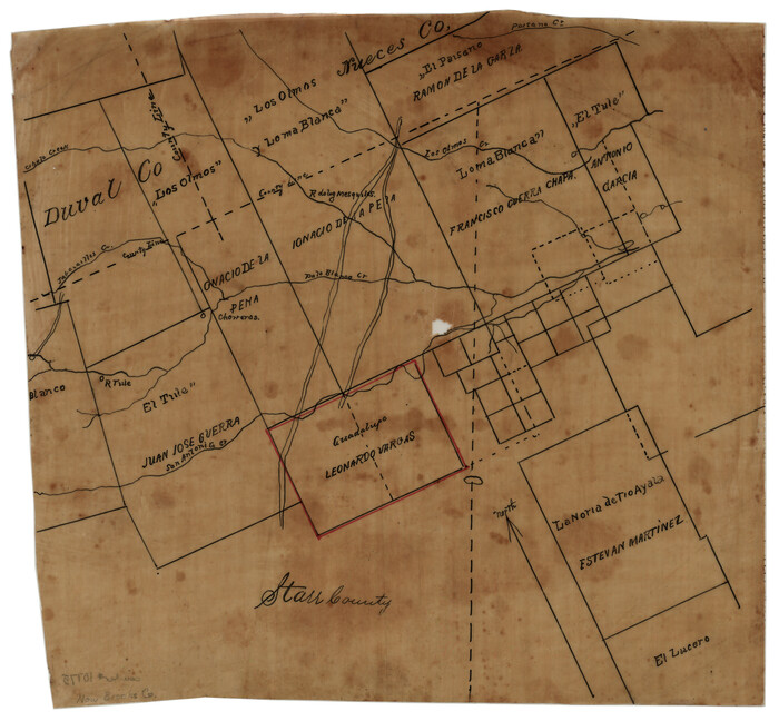
Nueces County Rolled Sketch 100

Print $20.00
- Digital $50.00
Nueces County Rolled Sketch 100
Size: 43.9 x 37.7 inches
10208
Nueces County Rolled Sketch 100

Print $20.00
- Digital $50.00
Nueces County Rolled Sketch 100
Size: 30.6 x 40.7 inches
10209
Nueces County Rolled Sketch 100

Print $20.00
- Digital $50.00
Nueces County Rolled Sketch 100
1938
Size: 30.4 x 30.4 inches
10210
Nueces County Rolled Sketch 104A

Print $40.00
- Digital $50.00
Nueces County Rolled Sketch 104A
1975
Size: 54.2 x 35.9 inches
10293
Nueces County Rolled Sketch 45

Print $20.00
- Digital $50.00
Nueces County Rolled Sketch 45
1941
Size: 40.5 x 45.0 inches
10295
Aransas County Sketch File 11

Print $40.00
- Digital $50.00
Aransas County Sketch File 11
Size: 40.6 x 31.4 inches
10318
Nueces County Rolled Sketch 100

Print $20.00
- Digital $50.00
Nueces County Rolled Sketch 100
Size: 21.3 x 32.7 inches
10697
Nueces County Rolled Sketch 41

Print $20.00
- Digital $50.00
Nueces County Rolled Sketch 41
1965
Size: 16.9 x 27.4 inches
10740
[Sketch of Surveys in Brooks County, Texas]
Print $20.00
- Digital $50.00
[Sketch of Surveys in Brooks County, Texas]
Size: 12.1 x 12.4 inches
10775
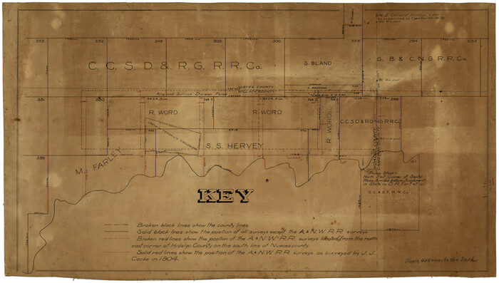
[Surveying Sketch of M. Farley, R. Word, S. S. Hervey, et al in Kleberg County, Texas]
Print $20.00
- Digital $50.00
[Surveying Sketch of M. Farley, R. Word, S. S. Hervey, et al in Kleberg County, Texas]
Size: 23.2 x 40.6 inches
10783
Aransas County Sketch File 12a

Print $8.00
- Digital $50.00
Aransas County Sketch File 12a
1889
Size: 14.1 x 8.8 inches
13122
Aransas County Sketch File 14

Print $36.00
- Digital $50.00
Aransas County Sketch File 14
1891
Size: 14.0 x 8.5 inches
13128
Aransas County Sketch File 18

Print $8.00
- Digital $50.00
Aransas County Sketch File 18
1888
Size: 12.7 x 8.2 inches
13149
Aransas County Sketch File 22

Print $34.00
- Digital $50.00
Aransas County Sketch File 22
1910
Size: 14.8 x 9.1 inches
13166
Aransas County Sketch File 26

Print $28.00
- Digital $50.00
Aransas County Sketch File 26
1896
Size: 5.2 x 4.7 inches
13219
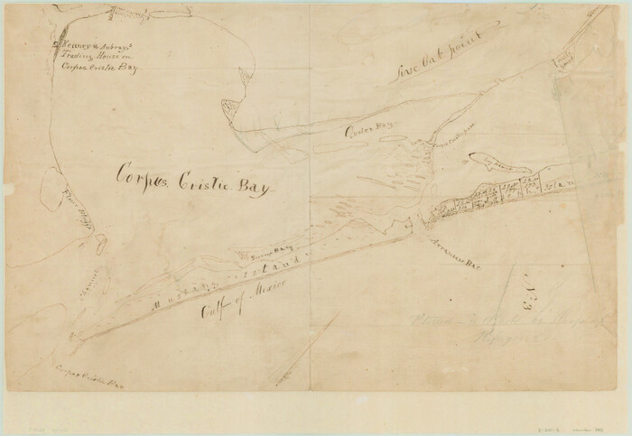
[Aransas and Corpus Christi Bays]
Print $3.00
- Digital $50.00
[Aransas and Corpus Christi Bays]
1839
Size: 11.4 x 16.5 inches
140
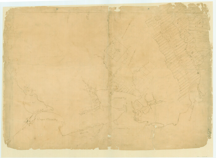
[Surveys on San Antonio River and Aransas Bay area]
Print $20.00
- Digital $50.00
[Surveys on San Antonio River and Aransas Bay area]
1840
Size: 24.1 x 33.0 inches
141
[Corpus Christi Bay and Aransas Bay]
Print $20.00
- Digital $50.00
[Corpus Christi Bay and Aransas Bay]
1840
Size: 17.1 x 22.4 inches
144
[Sketch with field note calls of the boundaries of Webb, Duval, Jim Wells,Nueces, Kleberg, Zapata, Jim Hogg, Brooks, Willacy, Starr, Hidalgo and Cameron Counties]
![1689, [Sketch with field note calls of the boundaries of Webb, Duval, Jim Wells,Nueces, Kleberg, Zapata, Jim Hogg, Brooks, Willacy, Starr, Hidalgo and Cameron Counties], General Map Collection](https://historictexasmaps.com/wmedia_w700/pdf_converted_jpg/qi_pdf_thumbnail_720.jpg)
Print $20.00
- Digital $50.00
[Sketch with field note calls of the boundaries of Webb, Duval, Jim Wells,Nueces, Kleberg, Zapata, Jim Hogg, Brooks, Willacy, Starr, Hidalgo and Cameron Counties]
1915
Size: 21.9 x 26.2 inches
1689
Copano, St. Charles, Aransas and Red Fish Bays, in Aransas and Nueces Counties, showing Subdivision for Mineral Development

Print $40.00
- Digital $50.00
Copano, St. Charles, Aransas and Red Fish Bays, in Aransas and Nueces Counties, showing Subdivision for Mineral Development
1949
Size: 55.9 x 40.0 inches
1914
Sketch Showing surveys on Harbor Island in Nueces County

Print $20.00
- Digital $50.00
Sketch Showing surveys on Harbor Island in Nueces County
1951
Size: 45.7 x 34.6 inches
1915
Mustang Island, Nueces County

Print $20.00
- Digital $50.00
Mustang Island, Nueces County
1952
Size: 39.5 x 35.4 inches
1918
State Tracts in East Part of Corpus Christi Bay, surveys on Harbor Island and Corpus Christi Channel, Nueces County

Print $40.00
- Digital $50.00
State Tracts in East Part of Corpus Christi Bay, surveys on Harbor Island and Corpus Christi Channel, Nueces County
1957
Size: 54.1 x 37.7 inches
1919
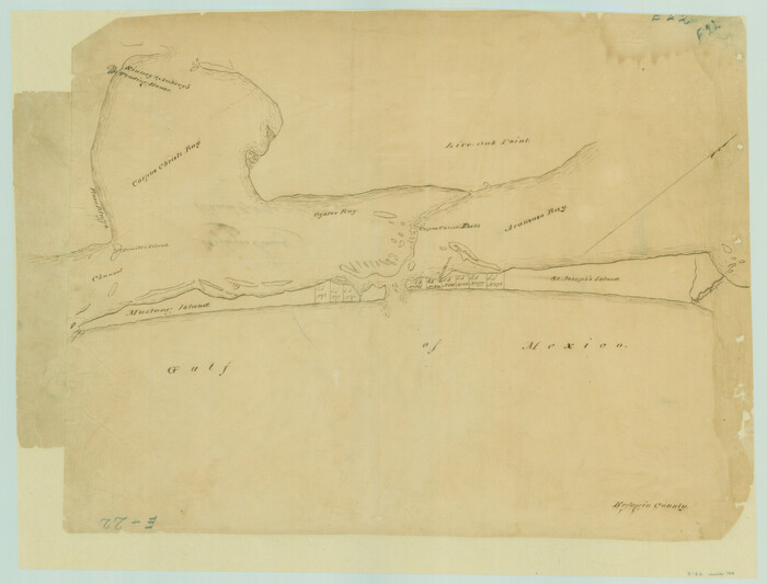
Office Sketch of surveys on St. Joseph and Mustang Islands, Aransas, and Nueces Counties

Print $20.00
- Digital $50.00
Office Sketch of surveys on St. Joseph and Mustang Islands, Aransas, and Nueces Counties
1957
Size: 42.6 x 18.0 inches
1920
Part of Laguna Madre in Nueces and Kleberg Counties, showing Subdivision for Mineral Development

Print $20.00
- Digital $50.00
Part of Laguna Madre in Nueces and Kleberg Counties, showing Subdivision for Mineral Development
1948
Size: 36.9 x 26.6 inches
1922
Texas Gulf Coast, from the Sabine River to the Rio Grande as Subdivided for Mineral Development; Aransas, Nueces, Kleberg, Kenedy, Willacy, and Cameron Counties

Print $40.00
- Digital $50.00
Texas Gulf Coast, from the Sabine River to the Rio Grande as Subdivided for Mineral Development; Aransas, Nueces, Kleberg, Kenedy, Willacy, and Cameron Counties
1976
Size: 118.0 x 43.0 inches
1940
Map of the District of San Patricio and Nueces

Print $40.00
- Digital $50.00
Map of the District of San Patricio and Nueces
Size: 93.8 x 67.5 inches
1955
Port Aransas-Corpus Christi Waterway, Texas, Avery Point Turning Basin to Vicinity of Tule Lake - Dredging

Print $20.00
- Digital $50.00
Port Aransas-Corpus Christi Waterway, Texas, Avery Point Turning Basin to Vicinity of Tule Lake - Dredging
1947
Size: 28.6 x 41.8 inches
1996
Public Land on Mustang Island, Nueces County

Print $20.00
- Digital $50.00
Public Land on Mustang Island, Nueces County
1910
Size: 17.0 x 17.5 inches
1997
Nueces County Rolled Sketch 45
Print $20.00
- Digital $50.00
Nueces County Rolled Sketch 45
1941
-
Size
41.0 x 40.9 inches
-
Map/Doc
10203
-
Creation Date
1941
Nueces County Rolled Sketch 100
Print $20.00
- Digital $50.00
Nueces County Rolled Sketch 100
-
Size
43.9 x 37.7 inches
-
Map/Doc
10208
Nueces County Rolled Sketch 100
Print $20.00
- Digital $50.00
Nueces County Rolled Sketch 100
-
Size
30.6 x 40.7 inches
-
Map/Doc
10209
Nueces County Rolled Sketch 100
Print $20.00
- Digital $50.00
Nueces County Rolled Sketch 100
1938
-
Size
30.4 x 30.4 inches
-
Map/Doc
10210
-
Creation Date
1938
Nueces County Rolled Sketch 104A
Print $40.00
- Digital $50.00
Nueces County Rolled Sketch 104A
1975
-
Size
54.2 x 35.9 inches
-
Map/Doc
10293
-
Creation Date
1975
Nueces County Rolled Sketch 45
Print $20.00
- Digital $50.00
Nueces County Rolled Sketch 45
1941
-
Size
40.5 x 45.0 inches
-
Map/Doc
10295
-
Creation Date
1941
Aransas County Sketch File 11
Print $40.00
- Digital $50.00
Aransas County Sketch File 11
-
Size
40.6 x 31.4 inches
-
Map/Doc
10318
Nueces County Rolled Sketch 100
Print $20.00
- Digital $50.00
Nueces County Rolled Sketch 100
-
Size
21.3 x 32.7 inches
-
Map/Doc
10697
Nueces County Rolled Sketch 41
Print $20.00
- Digital $50.00
Nueces County Rolled Sketch 41
1965
-
Size
16.9 x 27.4 inches
-
Map/Doc
10740
-
Creation Date
1965
[Sketch of Surveys in Brooks County, Texas]
Print $20.00
- Digital $50.00
[Sketch of Surveys in Brooks County, Texas]
-
Size
12.1 x 12.4 inches
-
Map/Doc
10775
[Surveying Sketch of M. Farley, R. Word, S. S. Hervey, et al in Kleberg County, Texas]
Print $20.00
- Digital $50.00
[Surveying Sketch of M. Farley, R. Word, S. S. Hervey, et al in Kleberg County, Texas]
-
Size
23.2 x 40.6 inches
-
Map/Doc
10783
Aransas County Sketch File 12a
Print $8.00
- Digital $50.00
Aransas County Sketch File 12a
1889
-
Size
14.1 x 8.8 inches
-
Map/Doc
13122
-
Creation Date
1889
Aransas County Sketch File 14
Print $36.00
- Digital $50.00
Aransas County Sketch File 14
1891
-
Size
14.0 x 8.5 inches
-
Map/Doc
13128
-
Creation Date
1891
Aransas County Sketch File 18
Print $8.00
- Digital $50.00
Aransas County Sketch File 18
1888
-
Size
12.7 x 8.2 inches
-
Map/Doc
13149
-
Creation Date
1888
Aransas County Sketch File 22
Print $34.00
- Digital $50.00
Aransas County Sketch File 22
1910
-
Size
14.8 x 9.1 inches
-
Map/Doc
13166
-
Creation Date
1910
Aransas County Sketch File 26
Print $28.00
- Digital $50.00
Aransas County Sketch File 26
1896
-
Size
5.2 x 4.7 inches
-
Map/Doc
13219
-
Creation Date
1896
[Aransas and Corpus Christi Bays]
Print $3.00
- Digital $50.00
[Aransas and Corpus Christi Bays]
1839
-
Size
11.4 x 16.5 inches
-
Map/Doc
140
-
Creation Date
1839
[Surveys on San Antonio River and Aransas Bay area]
Print $20.00
- Digital $50.00
[Surveys on San Antonio River and Aransas Bay area]
1840
-
Size
24.1 x 33.0 inches
-
Map/Doc
141
-
Creation Date
1840
[Corpus Christi Bay and Aransas Bay]
Print $20.00
- Digital $50.00
[Corpus Christi Bay and Aransas Bay]
1840
-
Size
17.1 x 22.4 inches
-
Map/Doc
144
-
Creation Date
1840
[Sketch with field note calls of the boundaries of Webb, Duval, Jim Wells,Nueces, Kleberg, Zapata, Jim Hogg, Brooks, Willacy, Starr, Hidalgo and Cameron Counties]
Print $20.00
- Digital $50.00
[Sketch with field note calls of the boundaries of Webb, Duval, Jim Wells,Nueces, Kleberg, Zapata, Jim Hogg, Brooks, Willacy, Starr, Hidalgo and Cameron Counties]
1915
-
Size
21.9 x 26.2 inches
-
Map/Doc
1689
-
Creation Date
1915
Copano, St. Charles, Aransas and Red Fish Bays, in Aransas and Nueces Counties, showing Subdivision for Mineral Development
Print $40.00
- Digital $50.00
Copano, St. Charles, Aransas and Red Fish Bays, in Aransas and Nueces Counties, showing Subdivision for Mineral Development
1949
-
Size
55.9 x 40.0 inches
-
Map/Doc
1914
-
Creation Date
1949
Sketch Showing surveys on Harbor Island in Nueces County
Print $20.00
- Digital $50.00
Sketch Showing surveys on Harbor Island in Nueces County
1951
-
Size
45.7 x 34.6 inches
-
Map/Doc
1915
-
Creation Date
1951
Mustang Island, Nueces County
Print $20.00
- Digital $50.00
Mustang Island, Nueces County
1952
-
Size
39.5 x 35.4 inches
-
Map/Doc
1918
-
Creation Date
1952
State Tracts in East Part of Corpus Christi Bay, surveys on Harbor Island and Corpus Christi Channel, Nueces County
Print $40.00
- Digital $50.00
State Tracts in East Part of Corpus Christi Bay, surveys on Harbor Island and Corpus Christi Channel, Nueces County
1957
-
Size
54.1 x 37.7 inches
-
Map/Doc
1919
-
Creation Date
1957
Office Sketch of surveys on St. Joseph and Mustang Islands, Aransas, and Nueces Counties
Print $20.00
- Digital $50.00
Office Sketch of surveys on St. Joseph and Mustang Islands, Aransas, and Nueces Counties
1957
-
Size
42.6 x 18.0 inches
-
Map/Doc
1920
-
Creation Date
1957
Part of Laguna Madre in Nueces and Kleberg Counties, showing Subdivision for Mineral Development
Print $20.00
- Digital $50.00
Part of Laguna Madre in Nueces and Kleberg Counties, showing Subdivision for Mineral Development
1948
-
Size
36.9 x 26.6 inches
-
Map/Doc
1922
-
Creation Date
1948
Texas Gulf Coast, from the Sabine River to the Rio Grande as Subdivided for Mineral Development; Aransas, Nueces, Kleberg, Kenedy, Willacy, and Cameron Counties
Print $40.00
- Digital $50.00
Texas Gulf Coast, from the Sabine River to the Rio Grande as Subdivided for Mineral Development; Aransas, Nueces, Kleberg, Kenedy, Willacy, and Cameron Counties
1976
-
Size
118.0 x 43.0 inches
-
Map/Doc
1940
-
Creation Date
1976
Map of the District of San Patricio and Nueces
Print $40.00
- Digital $50.00
Map of the District of San Patricio and Nueces
-
Size
93.8 x 67.5 inches
-
Map/Doc
1955
Port Aransas-Corpus Christi Waterway, Texas, Avery Point Turning Basin to Vicinity of Tule Lake - Dredging
Print $20.00
- Digital $50.00
Port Aransas-Corpus Christi Waterway, Texas, Avery Point Turning Basin to Vicinity of Tule Lake - Dredging
1947
-
Size
28.6 x 41.8 inches
-
Map/Doc
1996
-
Creation Date
1947
Public Land on Mustang Island, Nueces County
Print $20.00
- Digital $50.00
Public Land on Mustang Island, Nueces County
1910
-
Size
17.0 x 17.5 inches
-
Map/Doc
1997
-
Creation Date
1910