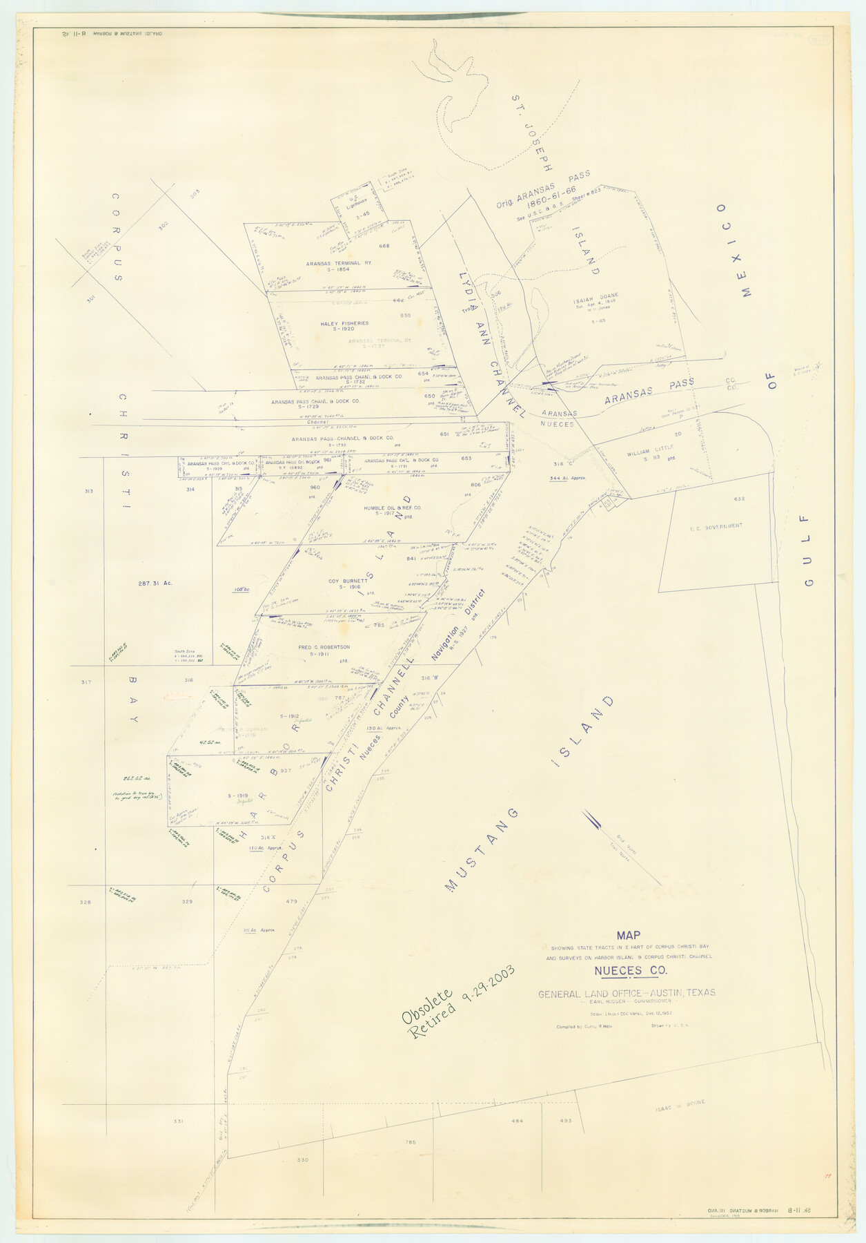
State Tracts in East Part of Corpus Christi Bay, surveys on Harbor Island and Corpus Christi Channel, Nueces County
-
Map/Doc
1919
-
Collection
General Map Collection
-
Object Dates
1957 (Creation Date)
-
People and Organizations
General Land Office (Publisher)
C.R. Hale (Compiler)
-
Counties
Nueces
-
Subjects
Energy Offshore Submerged Area
-
Height x Width
54.1 x 37.7 inches
137.4 x 95.8 cm
-
Medium
blueline cloth
-
Scale
200 varas
-
Comments
Gulf coast and submerged state land.
Part of: General Map Collection
Chart of the Harbour of San [Luis]
![72762, Chart of the Harbour of San [Luis], General Map Collection](https://historictexasmaps.com/wmedia_w700/maps/72762.tif.jpg)
Print $20.00
- Digital $50.00
Chart of the Harbour of San [Luis]
1846
Size 27.2 x 18.2 inches
Map/Doc 72762
North Part of Brewster Co.

Print $20.00
- Digital $50.00
North Part of Brewster Co.
1956
Size 42.1 x 40.2 inches
Map/Doc 73088
Map of the State of Texas

Print $40.00
- Digital $50.00
Map of the State of Texas
1879
Size 47.1 x 51.4 inches
Map/Doc 2133
Map of Mason County

Print $20.00
- Digital $50.00
Map of Mason County
1877
Size 25.3 x 19.9 inches
Map/Doc 3836
Map of Henderson County

Print $20.00
- Digital $50.00
Map of Henderson County
1877
Size 17.7 x 29.2 inches
Map/Doc 3666
Cooke County Working Sketch 10

Print $20.00
- Digital $50.00
Cooke County Working Sketch 10
1940
Size 40.5 x 27.8 inches
Map/Doc 68247
Roberts County Working Sketch 38

Print $20.00
- Digital $50.00
Roberts County Working Sketch 38
1978
Size 26.7 x 22.5 inches
Map/Doc 63564
A Map of Gonzales County

Print $20.00
- Digital $50.00
A Map of Gonzales County
1838
Size 34.7 x 39.2 inches
Map/Doc 16838
Flight Mission No. DCL-6C, Frame 132, Kenedy County

Print $20.00
- Digital $50.00
Flight Mission No. DCL-6C, Frame 132, Kenedy County
1943
Size 18.6 x 22.3 inches
Map/Doc 85962
Real County Working Sketch 13

Print $20.00
- Digital $50.00
Real County Working Sketch 13
1931
Size 24.2 x 33.3 inches
Map/Doc 71905
Cottle County Working Sketch 2

Print $3.00
- Digital $50.00
Cottle County Working Sketch 2
1902
Size 9.9 x 13.2 inches
Map/Doc 68312
Colorado River, Danevang Sheet

Print $6.00
- Digital $50.00
Colorado River, Danevang Sheet
1940
Size 24.6 x 35.2 inches
Map/Doc 65321
You may also like
Houston County Working Sketch 22

Print $20.00
- Digital $50.00
Houston County Working Sketch 22
1982
Size 31.2 x 44.1 inches
Map/Doc 66252
Dawson County Sketch File 5

Print $38.00
- Digital $50.00
Dawson County Sketch File 5
1924
Size 13.4 x 8.9 inches
Map/Doc 20509
El Paso County Sketch File 34

Print $82.00
- Digital $50.00
El Paso County Sketch File 34
1984
Size 14.3 x 8.9 inches
Map/Doc 22129
Houston County Working Sketch 17

Print $40.00
- Digital $50.00
Houston County Working Sketch 17
1968
Size 43.4 x 50.3 inches
Map/Doc 66247
Houston County Sketch File 28

Print $20.00
- Digital $50.00
Houston County Sketch File 28
1877
Size 21.8 x 21.3 inches
Map/Doc 11789
Nueces County Sketch File 67

Print $4.00
- Digital $50.00
Nueces County Sketch File 67
Size 11.1 x 8.7 inches
Map/Doc 32998
General Highway Map, Midland County, Texas

Print $20.00
General Highway Map, Midland County, Texas
1940
Size 18.2 x 24.5 inches
Map/Doc 79197
[Gulf, Colorado & Santa Fe Railway line through Fort Bend Co.]
![64212, [Gulf, Colorado & Santa Fe Railway line through Fort Bend Co.], General Map Collection](https://historictexasmaps.com/wmedia_w700/maps/64212.tif.jpg)
Print $20.00
- Digital $50.00
[Gulf, Colorado & Santa Fe Railway line through Fort Bend Co.]
1898
Size 14.2 x 33.5 inches
Map/Doc 64212
Map of Colorado County

Print $20.00
- Digital $50.00
Map of Colorado County
1880
Size 21.8 x 21.1 inches
Map/Doc 3426
Flight Mission No. DQN-5K, Frame 141, Calhoun County

Print $20.00
- Digital $50.00
Flight Mission No. DQN-5K, Frame 141, Calhoun County
1953
Size 18.7 x 21.9 inches
Map/Doc 84416
[Sketch for Mineral Applications 26885-6 - Reagan and Crockett Cos., W. H. Bland]
![2854, [Sketch for Mineral Applications 26885-6 - Reagan and Crockett Cos., W. H. Bland], General Map Collection](https://historictexasmaps.com/wmedia_w700/maps/2854.tif.jpg)
Print $20.00
- Digital $50.00
[Sketch for Mineral Applications 26885-6 - Reagan and Crockett Cos., W. H. Bland]
1932
Size 41.5 x 36.6 inches
Map/Doc 2854
Wayland Crossing Sheet Robertson, Limestone and Leon Counties, Navasota River

Print $20.00
- Digital $50.00
Wayland Crossing Sheet Robertson, Limestone and Leon Counties, Navasota River
1934
Size 43.9 x 40.9 inches
Map/Doc 65072