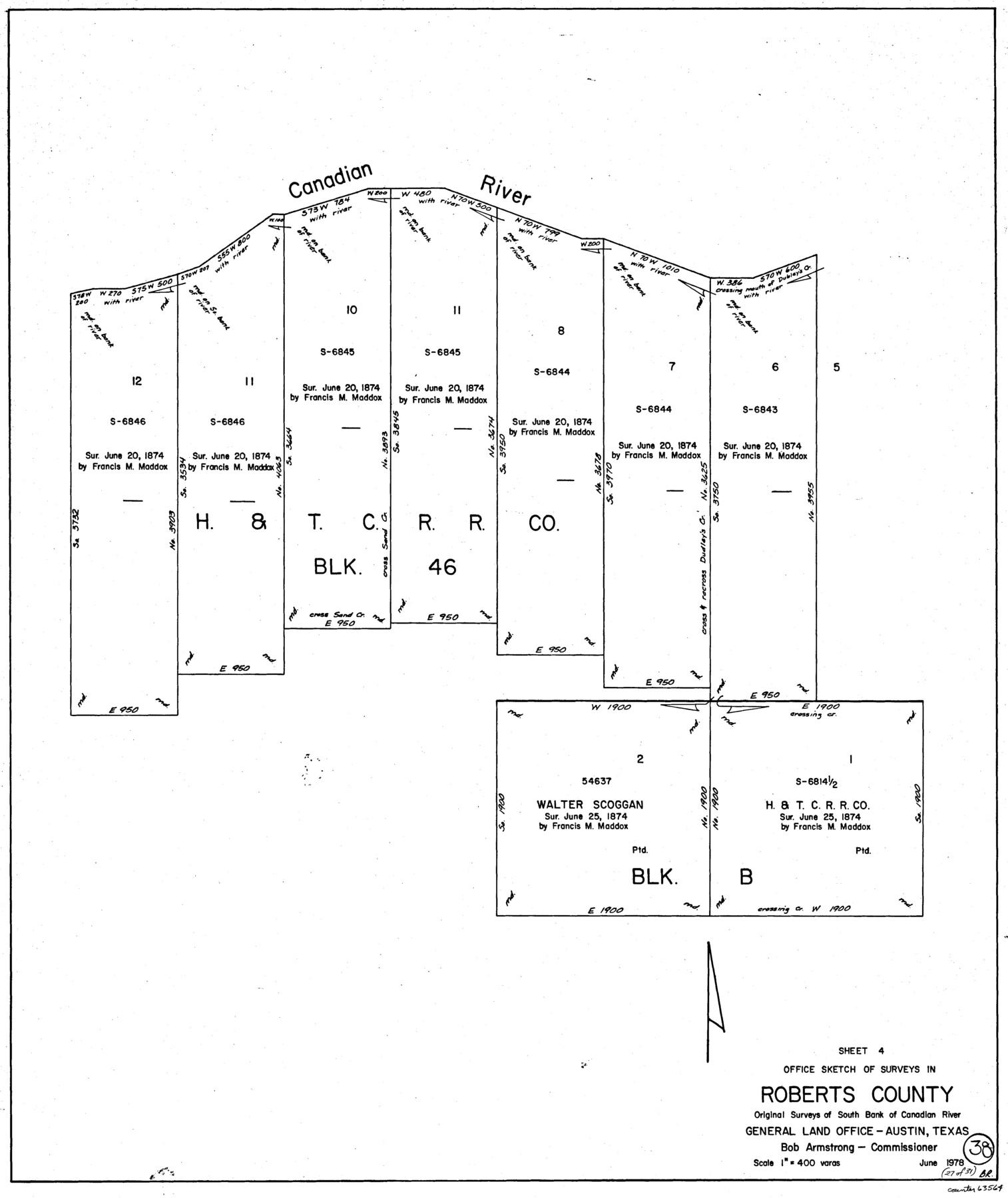
Roberts County Working Sketch 38
-
Map/Doc
63564
-
Collection
General Map Collection
-
Object Dates
6/1978 (Creation Date)
-
Counties
Roberts
-
Subjects
Surveying Working Sketch
-
Height x Width
26.7 x 22.5 inches
67.8 x 57.2 cm
-
Scale
1" = 400 varas
Part of: General Map Collection
Cameron County Boundary File 4

Print $42.00
- Digital $50.00
Cameron County Boundary File 4
Size 10.4 x 8.2 inches
Map/Doc 51110
Real County Working Sketch 36

Print $20.00
- Digital $50.00
Real County Working Sketch 36
1950
Size 24.7 x 35.9 inches
Map/Doc 71928
Flight Mission No. CRC-3R, Frame 164, Chambers County

Print $20.00
- Digital $50.00
Flight Mission No. CRC-3R, Frame 164, Chambers County
1956
Size 18.7 x 22.3 inches
Map/Doc 84846
[Geological Map of Texas]
![62962, [Geological Map of Texas], General Map Collection](https://historictexasmaps.com/wmedia_w700/maps/62962.tif.jpg)
Print $20.00
- Digital $50.00
[Geological Map of Texas]
Size 17.6 x 18.1 inches
Map/Doc 62962
Harris County Rolled Sketch 83

Print $20.00
- Digital $50.00
Harris County Rolled Sketch 83
1958
Size 28.2 x 45.6 inches
Map/Doc 9139
Flight Mission No. DCL-7C, Frame 123, Kenedy County

Print $20.00
- Digital $50.00
Flight Mission No. DCL-7C, Frame 123, Kenedy County
1943
Size 18.5 x 22.2 inches
Map/Doc 86088
Brazoria County Working Sketch 38

Print $40.00
- Digital $50.00
Brazoria County Working Sketch 38
1981
Size 53.2 x 37.7 inches
Map/Doc 67523
Lamb County Rolled Sketch 3

Print $20.00
- Digital $50.00
Lamb County Rolled Sketch 3
1917
Size 23.0 x 42.5 inches
Map/Doc 9413
Coryell County Boundary File 1c

Print $6.00
- Digital $50.00
Coryell County Boundary File 1c
Size 10.2 x 8.1 inches
Map/Doc 51901
Hamilton County Sketch File 3

Print $4.00
- Digital $50.00
Hamilton County Sketch File 3
1852
Size 12.7 x 8.0 inches
Map/Doc 24901
Post Route Map of Texas (Inset 1: Dallas-Fort Worth Area; Inset 2: Texas Panhandle)

Print $40.00
- Digital $50.00
Post Route Map of Texas (Inset 1: Dallas-Fort Worth Area; Inset 2: Texas Panhandle)
1939
Size 56.9 x 39.3 inches
Map/Doc 93668

You may also like
Roberts County Working Sketch 4

Print $20.00
- Digital $50.00
Roberts County Working Sketch 4
1945
Size 37.1 x 32.8 inches
Map/Doc 63530
Welch, Dawson County, Texas

Print $20.00
- Digital $50.00
Welch, Dawson County, Texas
Size 19.4 x 16.6 inches
Map/Doc 92592
[Block 28, Showing Edwards Ranch]
![91499, [Block 28, Showing Edwards Ranch], Twichell Survey Records](https://historictexasmaps.com/wmedia_w700/maps/91499-1.tif.jpg)
Print $3.00
- Digital $50.00
[Block 28, Showing Edwards Ranch]
Size 17.0 x 8.9 inches
Map/Doc 91499
Hood County Boundary File 41

Print $6.00
- Digital $50.00
Hood County Boundary File 41
Size 11.2 x 8.8 inches
Map/Doc 55041
Bosque County Working Sketch 33

Print $20.00
- Digital $50.00
Bosque County Working Sketch 33
2016
Size 37.0 x 25.0 inches
Map/Doc 93980
Flight Mission No. CGI-3N, Frame 167, Cameron County

Print $20.00
- Digital $50.00
Flight Mission No. CGI-3N, Frame 167, Cameron County
1954
Size 18.6 x 22.4 inches
Map/Doc 84631
Coryell County Sketch File 12

Print $20.00
- Digital $50.00
Coryell County Sketch File 12
1863
Size 21.7 x 19.3 inches
Map/Doc 11181
Kenedy County Rolled Sketch 8

Print $20.00
- Digital $50.00
Kenedy County Rolled Sketch 8
1915
Size 19.0 x 30.6 inches
Map/Doc 6468
San Saba County Working Sketch 1

Print $20.00
- Digital $50.00
San Saba County Working Sketch 1
1919
Size 15.3 x 15.3 inches
Map/Doc 63789
No. 2 Chart of Corpus Christi Pass, Texas

Print $20.00
- Digital $50.00
No. 2 Chart of Corpus Christi Pass, Texas
1878
Size 18.4 x 27.3 inches
Map/Doc 73016
Val Verde County Sketch File Z7

Print $20.00
- Digital $50.00
Val Verde County Sketch File Z7
Size 25.6 x 17.2 inches
Map/Doc 12552
Pecos County Rolled Sketch 154

Print $20.00
- Digital $50.00
Pecos County Rolled Sketch 154
Size 35.9 x 27.0 inches
Map/Doc 7283