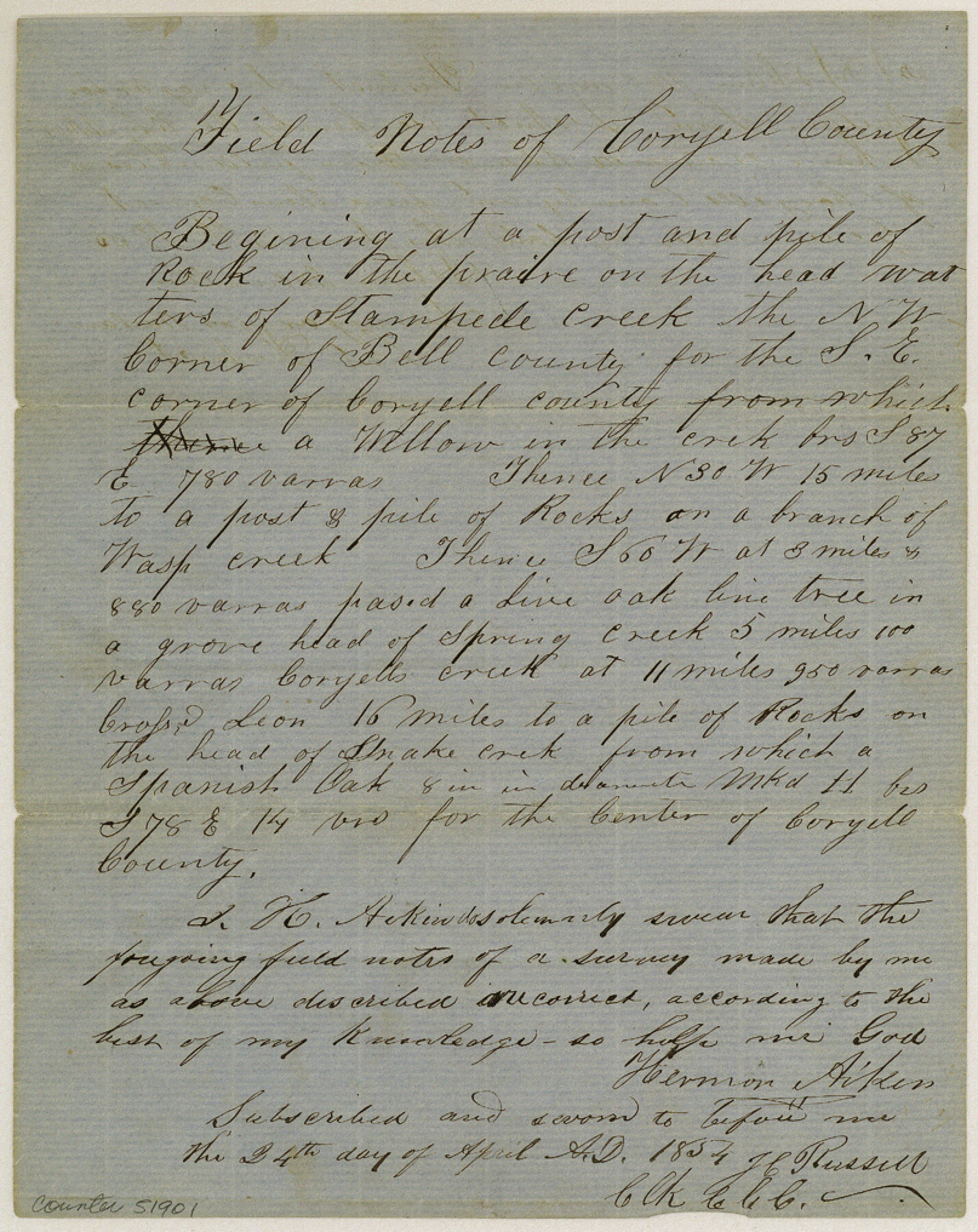
Coryell County Boundary File 1c
[Field Notes of Coryell County]
-
Map/Doc
51901
-
Collection
General Map Collection
-
Counties
Coryell
-
Subjects
County Boundaries
-
Height x Width
10.2 x 8.1 inches
25.9 x 20.6 cm
Part of: General Map Collection
Culberson County Sketch File 15

Print $20.00
- Digital $50.00
Culberson County Sketch File 15
1933
Size 30.4 x 24.4 inches
Map/Doc 11267
Parker County Working Sketch Graphic Index

Print $20.00
- Digital $50.00
Parker County Working Sketch Graphic Index
1942
Map/Doc 76661
Live Oak County Rolled Sketch 3

Print $20.00
- Digital $50.00
Live Oak County Rolled Sketch 3
1944
Size 31.2 x 47.2 inches
Map/Doc 10630
Morris County Rolled Sketch 2A

Print $20.00
- Digital $50.00
Morris County Rolled Sketch 2A
Size 24.2 x 19.1 inches
Map/Doc 10267
Calhoun County Rolled Sketch 29B

Print $20.00
- Digital $50.00
Calhoun County Rolled Sketch 29B
Size 43.4 x 45.0 inches
Map/Doc 8558
Travis County Working Sketch 61

Print $20.00
- Digital $50.00
Travis County Working Sketch 61
1995
Size 20.9 x 24.7 inches
Map/Doc 69445
Lee County Rolled Sketch 1

Print $40.00
- Digital $50.00
Lee County Rolled Sketch 1
1939
Size 71.0 x 42.4 inches
Map/Doc 10739
Limestone County Working Sketch 14

Print $20.00
- Digital $50.00
Limestone County Working Sketch 14
1922
Size 36.2 x 34.1 inches
Map/Doc 70564
Moore County Working Sketch 13

Print $40.00
- Digital $50.00
Moore County Working Sketch 13
1967
Size 38.2 x 87.5 inches
Map/Doc 71195
Foard County Rolled Sketch 11

Print $20.00
- Digital $50.00
Foard County Rolled Sketch 11
Size 29.2 x 35.6 inches
Map/Doc 5885
Coast Chart No. 210 - Aransas Pass and Corpus Christi Bay with the coast to latitude 27° 12', Texas

Print $20.00
- Digital $50.00
Coast Chart No. 210 - Aransas Pass and Corpus Christi Bay with the coast to latitude 27° 12', Texas
1907
Size 15.4 x 23.5 inches
Map/Doc 73451
Flight Mission No. DIX-5P, Frame 106, Aransas County

Print $20.00
- Digital $50.00
Flight Mission No. DIX-5P, Frame 106, Aransas County
1956
Size 17.8 x 18.0 inches
Map/Doc 83784
You may also like
Sketch Z [Blocks K6 and K11]
![90610, Sketch Z [Blocks K6 and K11], Twichell Survey Records](https://historictexasmaps.com/wmedia_w700/maps/90610-1.tif.jpg)
Print $20.00
- Digital $50.00
Sketch Z [Blocks K6 and K11]
1903
Size 28.2 x 27.0 inches
Map/Doc 90610
Austin including Bergstrom AFB, Hays, Mansfield Dam, McKinney Falls State Park, Oak Hill, Rollingwood, San Leanna, Sunset Valley and West Lake Hills - also portions of Pflugerville

Austin including Bergstrom AFB, Hays, Mansfield Dam, McKinney Falls State Park, Oak Hill, Rollingwood, San Leanna, Sunset Valley and West Lake Hills - also portions of Pflugerville
Size 38.5 x 25.6 inches
Map/Doc 94376
Polk County Sketch File 27

Print $8.00
- Digital $50.00
Polk County Sketch File 27
1891
Size 14.1 x 8.7 inches
Map/Doc 34194
Crockett County Rolled Sketch E

Print $20.00
- Digital $50.00
Crockett County Rolled Sketch E
1907
Size 26.2 x 27.7 inches
Map/Doc 5636
Texas, Matagorda Bay, Port O'Connor to Gallinipper Point

Print $40.00
- Digital $50.00
Texas, Matagorda Bay, Port O'Connor to Gallinipper Point
1933
Size 31.1 x 48.6 inches
Map/Doc 69985
Jefferson County Working Sketch 43

Print $20.00
- Digital $50.00
Jefferson County Working Sketch 43
1960
Size 42.7 x 31.1 inches
Map/Doc 73591
Texas Gulf Coast, from the Sabine River to the Rio Grande as Subdivided for Mineral Development; Galveston, Brazoria and Matagorda Counties

Print $40.00
- Digital $50.00
Texas Gulf Coast, from the Sabine River to the Rio Grande as Subdivided for Mineral Development; Galveston, Brazoria and Matagorda Counties
1976
Size 43.8 x 69.3 inches
Map/Doc 1938
Williamson County Boundary File 1

Print $66.00
- Digital $50.00
Williamson County Boundary File 1
Size 8.4 x 6.0 inches
Map/Doc 59974
Fisher County

Print $40.00
- Digital $50.00
Fisher County
1944
Size 48.4 x 42.5 inches
Map/Doc 73147
Navarro County Sketch File 17

Print $4.00
- Digital $50.00
Navarro County Sketch File 17
Size 12.8 x 8.4 inches
Map/Doc 32333
[Blocks O5, O2, O, JD, A1, A2, A3, A4, B, T, D10, and vicinity]
![90717, [Blocks O5, O2, O, JD, A1, A2, A3, A4, B, T, D10, and vicinity], Twichell Survey Records](https://historictexasmaps.com/wmedia_w700/maps/90717-1.tif.jpg)
Print $20.00
- Digital $50.00
[Blocks O5, O2, O, JD, A1, A2, A3, A4, B, T, D10, and vicinity]
Size 34.7 x 29.3 inches
Map/Doc 90717
Chambers County Rolled Sketch 25A

Print $20.00
- Digital $50.00
Chambers County Rolled Sketch 25A
1944
Size 41.2 x 34.5 inches
Map/Doc 8617