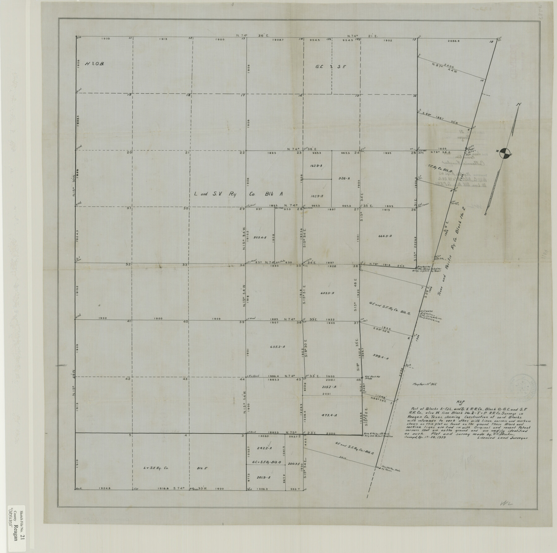
Reagan County Sketch File 21
Pt. of Blks. A-F & L & S.W. RR Co., Blk. O, GC & SH RR. Co. W. Line Blk, No. 2 T&PRR. Co.
-
Map/Doc
10585
-
Collection
General Map Collection
-
Object Dates
1939/4/28 (Creation Date)
1939/6/1 (File Date)
1939/4/28 (Survey Date)
-
People and Organizations
V.V. Strahan (Surveyor/Engineer)
-
Counties
Reagan
-
Subjects
Surveying Sketch File
-
Height x Width
31.1 x 31.3 inches
79.0 x 79.5 cm
-
Medium
paper, manuscript
Part of: General Map Collection
Jasper County Sketch File 18

Print $32.00
- Digital $50.00
Jasper County Sketch File 18
1890
Size 12.6 x 7.9 inches
Map/Doc 27808
Sabine and Neches Rivers

Print $20.00
- Digital $50.00
Sabine and Neches Rivers
1925
Size 19.6 x 44.0 inches
Map/Doc 69816
Reeves County Sketch File 11

Print $20.00
- Digital $50.00
Reeves County Sketch File 11
1891
Size 20.1 x 17.9 inches
Map/Doc 12245
[Houston & Texas Central Ry.]
![64363, [Houston & Texas Central Ry.], General Map Collection](https://historictexasmaps.com/wmedia_w700/maps/64363.tif.jpg)
Print $20.00
- Digital $50.00
[Houston & Texas Central Ry.]
1939
Size 15.5 x 13.8 inches
Map/Doc 64363
Harris County Rolled Sketch 63

Print $40.00
- Digital $50.00
Harris County Rolled Sketch 63
1936
Size 41.4 x 52.5 inches
Map/Doc 9120
Map of Coryell Co[unty]
![16951, Map of Coryell Co[unty], General Map Collection](https://historictexasmaps.com/wmedia_w700/maps/16951-1.tif.jpg)
Print $40.00
- Digital $50.00
Map of Coryell Co[unty]
1896
Size 49.8 x 47.7 inches
Map/Doc 16951
[Surveys along the San Jacinto River]
![62, [Surveys along the San Jacinto River], General Map Collection](https://historictexasmaps.com/wmedia_w700/maps/62.tif.jpg)
Print $3.00
- Digital $50.00
[Surveys along the San Jacinto River]
1841
Size 10.7 x 14.5 inches
Map/Doc 62
Dimmit County Sketch File 10

Print $20.00
- Digital $50.00
Dimmit County Sketch File 10
Size 23.5 x 22.6 inches
Map/Doc 11338

Wichita County Working Sketch 9

Print $20.00
- Digital $50.00
Wichita County Working Sketch 9
1920
Size 23.7 x 17.6 inches
Map/Doc 72518
Borden County Working Sketch 14

Print $20.00
- Digital $50.00
Borden County Working Sketch 14
1959
Size 27.8 x 25.2 inches
Map/Doc 67474
Orange County Sketch File 9

Print $20.00
- Digital $50.00
Orange County Sketch File 9
1874
Size 12.7 x 22.9 inches
Map/Doc 12117
You may also like
Roberts County Sketch File 6

Print $6.00
- Digital $50.00
Roberts County Sketch File 6
1935
Size 10.8 x 14.5 inches
Map/Doc 35314
Gregg County Working Sketch 4

Print $20.00
- Digital $50.00
Gregg County Working Sketch 4
1931
Size 29.1 x 32.9 inches
Map/Doc 63270

Zapata County Rolled Sketch 14

Print $20.00
- Digital $50.00
Zapata County Rolled Sketch 14
1925
Size 19.2 x 43.7 inches
Map/Doc 10168
Midland County Working Sketch 28

Print $20.00
- Digital $50.00
Midland County Working Sketch 28
1968
Size 29.7 x 31.7 inches
Map/Doc 71009
General Highway Map, Throckmorton County, Texas

Print $20.00
General Highway Map, Throckmorton County, Texas
1961
Size 18.2 x 24.8 inches
Map/Doc 79676
Bosque County Sketch File 30

Print $6.00
- Digital $50.00
Bosque County Sketch File 30
Size 7.6 x 7.6 inches
Map/Doc 14819
Right of Way and Track Map of The Missouri, Kansas & Texas Railway of Texas

Print $40.00
- Digital $50.00
Right of Way and Track Map of The Missouri, Kansas & Texas Railway of Texas
1918
Size 25.3 x 56.1 inches
Map/Doc 64528

Bastrop County Sketch File 4

Print $4.00
- Digital $50.00
Bastrop County Sketch File 4
1873
Size 12.7 x 7.9 inches
Map/Doc 14046
Flight Mission No. CRC-3R, Frame 27, Chambers County

Print $20.00
- Digital $50.00
Flight Mission No. CRC-3R, Frame 27, Chambers County
1956
Size 18.7 x 22.3 inches
Map/Doc 84801
Lampasas County Working Sketch 19

Print $40.00
- Digital $50.00
Lampasas County Working Sketch 19
1979
Size 43.8 x 48.3 inches
Map/Doc 70296