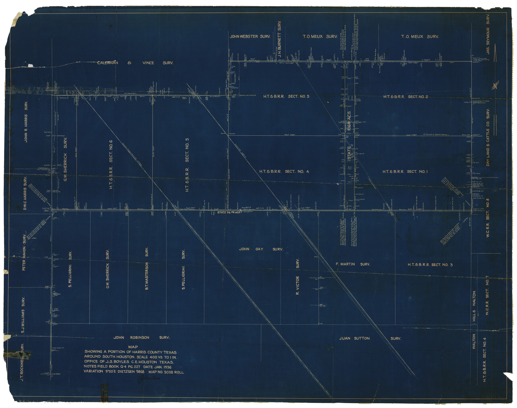
Harris County Rolled Sketch 63
Map showing a portion of Harris County, Texas around south Houston
-
Map/Doc
9120
-
Collection
General Map Collection
-
Object Dates
1936 (Creation Date)
-
People and Organizations
J.S. Boyles (Surveyor/Engineer)
-
Counties
Harris
-
Subjects
Surveying Rolled Sketch
-
Height x Width
41.4 x 52.5 inches
105.2 x 133.4 cm
-
Medium
blueprint/diazo
-
Scale
1" = 400 varas
Part of: General Map Collection
San Patricio County Sketch File 27

Print $4.00
San Patricio County Sketch File 27
Size 14.5 x 8.8 inches
Map/Doc 36085
Crane County Sketch File 13b

Print $40.00
- Digital $50.00
Crane County Sketch File 13b
1901
Size 11.4 x 13.8 inches
Map/Doc 19573
Bee County Sketch File 30

Print $6.00
- Digital $50.00
Bee County Sketch File 30
Size 14.2 x 8.9 inches
Map/Doc 14341
Motley County Sketch File 15 (N)

Print $20.00
- Digital $50.00
Motley County Sketch File 15 (N)
Size 20.6 x 26.0 inches
Map/Doc 42143
Edwards County Sketch File 17

Print $20.00
- Digital $50.00
Edwards County Sketch File 17
Size 31.8 x 18.3 inches
Map/Doc 11429
The Great Texas Coastal Birding Trail, Central Texas Coast

The Great Texas Coastal Birding Trail, Central Texas Coast
Size 33.3 x 36.0 inches
Map/Doc 94340
Lamar County Working Sketch Graphic Index

Print $20.00
- Digital $50.00
Lamar County Working Sketch Graphic Index
1934
Size 47.9 x 37.5 inches
Map/Doc 76612
Parker County Sketch File 9

Print $4.00
- Digital $50.00
Parker County Sketch File 9
Size 8.1 x 10.0 inches
Map/Doc 33538
McLennan County Sketch File 31

Print $22.00
- Digital $50.00
McLennan County Sketch File 31
Size 14.2 x 17.2 inches
Map/Doc 31306
Red River County Working Sketch 22

Print $20.00
- Digital $50.00
Red River County Working Sketch 22
1955
Size 27.9 x 26.8 inches
Map/Doc 72005
Austin including Bergstrom AFB, Hays, Mansfield Dam, McKinney Falls State Park, Oak Hill, Rollingwood, San Leanna, Sunset Valley and West Lake Hills - also portions of Pflugerville

Austin including Bergstrom AFB, Hays, Mansfield Dam, McKinney Falls State Park, Oak Hill, Rollingwood, San Leanna, Sunset Valley and West Lake Hills - also portions of Pflugerville
Size 38.4 x 25.6 inches
Map/Doc 94375
Right of Way and Track Map, the Missouri, Kansas and Texas Ry. of Texas operated by the Missouri, Kansas and Texas Ry. of Texas, San Antonio Division

Print $40.00
- Digital $50.00
Right of Way and Track Map, the Missouri, Kansas and Texas Ry. of Texas operated by the Missouri, Kansas and Texas Ry. of Texas, San Antonio Division
1918
Size 25.6 x 58.7 inches
Map/Doc 64581
You may also like
Panola County Sketch File 20

Print $22.00
- Digital $50.00
Panola County Sketch File 20
Size 8.3 x 14.6 inches
Map/Doc 33485
Harris County Sketch File 33a

Print $20.00
- Digital $50.00
Harris County Sketch File 33a
Size 34.1 x 30.0 inches
Map/Doc 10478
Engineer's Office, Department of the Gulf Map No. 59, Texas prepared by order of Maj. Gen. N. P. Banks under direction of Capt. P. C. Hains, U. S. Engr. & Chief Engr., Dept. of the Gulf

Print $20.00
- Digital $50.00
Engineer's Office, Department of the Gulf Map No. 59, Texas prepared by order of Maj. Gen. N. P. Banks under direction of Capt. P. C. Hains, U. S. Engr. & Chief Engr., Dept. of the Gulf
1865
Size 18.3 x 27.6 inches
Map/Doc 72717
[Tie line between Indianola RR. Co. Block H and H. & G. N. RR. Co. Block G and vicinity]
![93007, [Tie line between Indianola RR. Co. Block H and H. & G. N. RR. Co. Block G and vicinity], Twichell Survey Records](https://historictexasmaps.com/wmedia_w700/maps/93007-1.tif.jpg)
Print $20.00
- Digital $50.00
[Tie line between Indianola RR. Co. Block H and H. & G. N. RR. Co. Block G and vicinity]
1904
Size 21.9 x 10.1 inches
Map/Doc 93007
Harris County Rolled Sketch R & B

Print $40.00
- Digital $50.00
Harris County Rolled Sketch R & B
1901
Size 27.9 x 60.6 inches
Map/Doc 8344
Mason County Working Sketch 17

Print $20.00
- Digital $50.00
Mason County Working Sketch 17
1983
Size 24.3 x 41.1 inches
Map/Doc 70853
Exhibit D Robert Violette M.A. 34719 Gaines County, Texas

Print $40.00
- Digital $50.00
Exhibit D Robert Violette M.A. 34719 Gaines County, Texas
Size 23.6 x 70.2 inches
Map/Doc 89767
Wichita County Sketch File 32

Print $12.00
- Digital $50.00
Wichita County Sketch File 32
1939
Size 14.2 x 8.8 inches
Map/Doc 40146
Reagan County Boundary File 1c

Print $56.00
- Digital $50.00
Reagan County Boundary File 1c
Size 9.2 x 8.2 inches
Map/Doc 58171
[San Antonio & Aransas Pass Railway Co.]
![64262, [San Antonio & Aransas Pass Railway Co.], General Map Collection](https://historictexasmaps.com/wmedia_w700/maps/64262-1.tif.jpg)
Print $40.00
- Digital $50.00
[San Antonio & Aransas Pass Railway Co.]
Size 15.7 x 86.4 inches
Map/Doc 64262
Jesse Devore League

Print $20.00
- Digital $50.00
Jesse Devore League
1919
Size 45.6 x 37.4 inches
Map/Doc 65460
Bosque County Working Sketch 1

Print $20.00
- Digital $50.00
Bosque County Working Sketch 1
Size 16.3 x 13.7 inches
Map/Doc 67434