Wichita County Sketch File 32
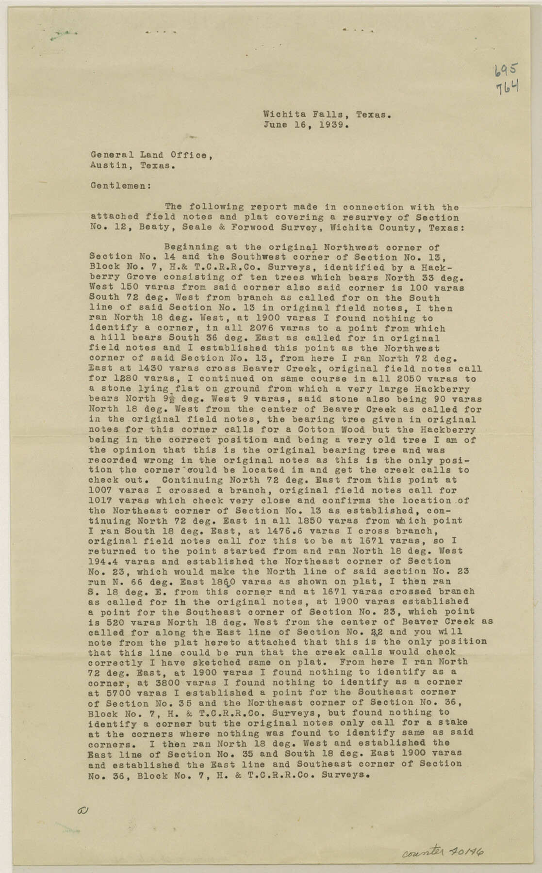
[Surveyor's report and supplemental report regarding a resurvey of section 12, B. S. & F. due west from Wichita Falls]
-
Map/Doc
40146
-
Collection
General Map Collection
-
Object Dates
6/16/1939 (Creation Date)
8/10/1939 (File Date)
8/8/1939 (Revision Date)
-
People and Organizations
Ross Corlett (Surveyor/Engineer)
-
Counties
Wichita
-
Subjects
Surveying Sketch File
-
Height x Width
14.2 x 8.8 inches
36.1 x 22.4 cm
-
Medium
paper, print
-
Comments
See Wichita County Rolled Sketch 15 (8252) for sketch.
-
Features
Beaver Creek
Related maps
Wichita County Rolled Sketch 15

Print $20.00
- Digital $50.00
Wichita County Rolled Sketch 15
Size 17.0 x 37.1 inches
Map/Doc 8252
Part of: General Map Collection
Webb County Working Sketch 27

Print $20.00
- Digital $50.00
Webb County Working Sketch 27
1932
Size 24.0 x 19.5 inches
Map/Doc 72392
Tom Green County Boundary File 3

Print $30.00
- Digital $50.00
Tom Green County Boundary File 3
Size 14.4 x 8.7 inches
Map/Doc 59341
Map of the County of Calhoun

Print $20.00
- Digital $50.00
Map of the County of Calhoun
1852
Size 21.0 x 20.4 inches
Map/Doc 4431
Haskell County Sketch File 26

Print $9.00
- Digital $50.00
Haskell County Sketch File 26
1992
Size 11.3 x 8.8 inches
Map/Doc 26182
Hemphill County Rolled Sketch 11

Print $20.00
- Digital $50.00
Hemphill County Rolled Sketch 11
1941
Size 45.4 x 22.2 inches
Map/Doc 9152
Wood County Sketch File 11

Print $4.00
- Digital $50.00
Wood County Sketch File 11
1858
Size 12.7 x 8.0 inches
Map/Doc 40664
Brazoria County Sketch File 37

Print $40.00
- Digital $50.00
Brazoria County Sketch File 37
1916
Size 20.6 x 30.1 inches
Map/Doc 10959
Dawson County Sketch File B

Print $10.00
- Digital $50.00
Dawson County Sketch File B
1917
Size 11.5 x 8.8 inches
Map/Doc 20465
Maps of Gulf Intracoastal Waterway, Texas - Sabine River to the Rio Grande and connecting waterways including ship channels

Print $20.00
- Digital $50.00
Maps of Gulf Intracoastal Waterway, Texas - Sabine River to the Rio Grande and connecting waterways including ship channels
1966
Size 14.5 x 22.1 inches
Map/Doc 61917
Travis County Working Sketch 17

Print $20.00
- Digital $50.00
Travis County Working Sketch 17
1944
Size 27.8 x 23.3 inches
Map/Doc 69401
Pecos County Working Sketch 125

Print $40.00
- Digital $50.00
Pecos County Working Sketch 125
1974
Size 53.4 x 37.0 inches
Map/Doc 71598
Duval County Working Sketch 10

Print $20.00
- Digital $50.00
Duval County Working Sketch 10
1936
Size 20.1 x 20.3 inches
Map/Doc 68723
You may also like
The North Part of America Conteyning Newfoundland, New England, Virginia, Florida, New Spaine, and Nova Francia

Print $20.00
- Digital $50.00
The North Part of America Conteyning Newfoundland, New England, Virginia, Florida, New Spaine, and Nova Francia
1625
Size 12.6 x 16.2 inches
Map/Doc 97028
Flight Mission No. DQN-2K, Frame 2, Calhoun County

Print $20.00
- Digital $50.00
Flight Mission No. DQN-2K, Frame 2, Calhoun County
1953
Size 18.6 x 22.3 inches
Map/Doc 84219
Haskell County Rolled Sketch 14

Print $3.00
- Digital $50.00
Haskell County Rolled Sketch 14
1991
Size 11.1 x 17.1 inches
Map/Doc 6172
[Survey 321, Double Lakes Area, Northwest of Tohoka]
![91299, [Survey 321, Double Lakes Area, Northwest of Tohoka], Twichell Survey Records](https://historictexasmaps.com/wmedia_w700/maps/91299-1.tif.jpg)
Print $20.00
- Digital $50.00
[Survey 321, Double Lakes Area, Northwest of Tohoka]
Size 26.9 x 19.5 inches
Map/Doc 91299
[Report showing connections and corners made on ground in south part of Yoakum County and north part of Gaines County, Texas]

[Report showing connections and corners made on ground in south part of Yoakum County and north part of Gaines County, Texas]
1938
Size 8.1 x 10.9 inches
Map/Doc 93256
Map of Taylor County Travis- Young- Bexar- Land District

Print $20.00
- Digital $50.00
Map of Taylor County Travis- Young- Bexar- Land District
1859
Size 25.1 x 20.4 inches
Map/Doc 4071
[San Antonio & Aransas Pass]
![64209, [San Antonio & Aransas Pass], General Map Collection](https://historictexasmaps.com/wmedia_w700/maps/64209.tif.jpg)
Print $20.00
- Digital $50.00
[San Antonio & Aransas Pass]
Size 15.2 x 45.5 inches
Map/Doc 64209
Calhoun County NRC Article 33.136 Sketch 1

Print $42.00
- Digital $50.00
Calhoun County NRC Article 33.136 Sketch 1
2000
Size 16.8 x 21.7 inches
Map/Doc 61556
Hamilton County Sketch File 6

Print $6.00
- Digital $50.00
Hamilton County Sketch File 6
Size 15.7 x 10.6 inches
Map/Doc 24910
Presidio County Rolled Sketch D

Print $20.00
- Digital $50.00
Presidio County Rolled Sketch D
Size 13.7 x 22.4 inches
Map/Doc 7408
Map of subdivision of submerged land in the Gulf of Mexico fronting on Matagorda Island and Peninsula

Print $40.00
- Digital $50.00
Map of subdivision of submerged land in the Gulf of Mexico fronting on Matagorda Island and Peninsula
1940
Size 28.3 x 60.5 inches
Map/Doc 2928
Flight Mission No. BRA-7M, Frame 202, Jefferson County

Print $20.00
- Digital $50.00
Flight Mission No. BRA-7M, Frame 202, Jefferson County
1953
Size 18.6 x 22.3 inches
Map/Doc 85570