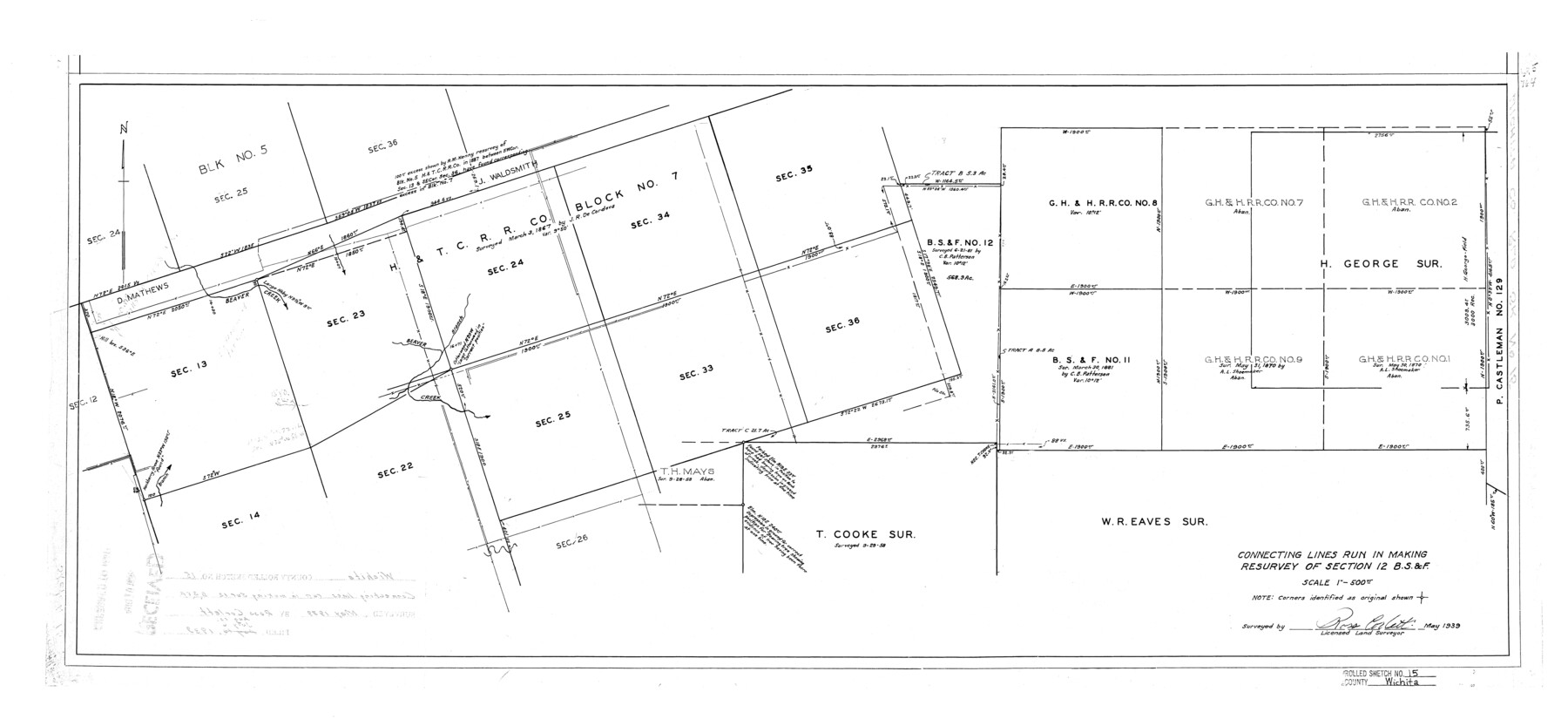
Wichita County Rolled Sketch 15
Connecting lines run in making resurvey of section 12, B. S. & F.
-
Map/Doc
8252
-
Collection
General Map Collection
-
Object Dates
1939 (Survey Date)
1939/8/10 (File Date)
-
People and Organizations
Ross Corlett (Surveyor/Engineer)
-
Counties
Wichita
-
Subjects
Surveying Rolled Sketch
-
Height x Width
17.0 x 37.1 inches
43.2 x 94.2 cm
-
Scale
1" = 500 varas
Related maps
Wichita County Sketch File 32

Print $12.00
- Digital $50.00
Wichita County Sketch File 32
1939
Size 14.2 x 8.8 inches
Map/Doc 40146
Part of: General Map Collection
Irion County Working Sketch 14

Print $40.00
- Digital $50.00
Irion County Working Sketch 14
1973
Size 56.3 x 30.8 inches
Map/Doc 66423

McMullen County Working Sketch 45

Print $20.00
- Digital $50.00
McMullen County Working Sketch 45
1981
Size 47.6 x 38.5 inches
Map/Doc 70746
Hamilton County Working Sketch 20

Print $20.00
- Digital $50.00
Hamilton County Working Sketch 20
1953
Size 32.5 x 30.8 inches
Map/Doc 63358
Brewster County Working Sketch 94

Print $40.00
- Digital $50.00
Brewster County Working Sketch 94
1975
Size 58.7 x 39.5 inches
Map/Doc 67694
Childress County Rolled Sketch 4

Print $20.00
- Digital $50.00
Childress County Rolled Sketch 4
1891
Size 18.8 x 42.2 inches
Map/Doc 5438
Plan of the City of Galveston, Texas

Print $20.00
- Digital $50.00
Plan of the City of Galveston, Texas
1845
Size 18.2 x 27.7 inches
Map/Doc 62967
Lynn County Boundary File 12

Print $60.00
- Digital $50.00
Lynn County Boundary File 12
Size 14.0 x 17.5 inches
Map/Doc 56749

El Paso County Sketch File 10

Print $52.00
- Digital $50.00
El Paso County Sketch File 10
1890
Size 8.4 x 5.4 inches
Map/Doc 21974
Fort Bend County Working Sketch 32

Print $20.00
- Digital $50.00
Fort Bend County Working Sketch 32
2000
Size 36.5 x 42.5 inches
Map/Doc 69238
No. 1. Outline Map of the Rio Grande from its mouth up to Ringold Barracks

Print $20.00
- Digital $50.00
No. 1. Outline Map of the Rio Grande from its mouth up to Ringold Barracks
Size 24.5 x 18.3 inches
Map/Doc 72858
You may also like
Goliad County Working Sketch Graphic Index

Print $20.00
- Digital $50.00
Goliad County Working Sketch Graphic Index
1946
Size 42.2 x 44.9 inches
Map/Doc 76555
Smith County Sketch File 12

Print $4.00
- Digital $50.00
Smith County Sketch File 12
1859
Size 8.3 x 12.0 inches
Map/Doc 36769
Lubbock County Sketch

Print $20.00
- Digital $50.00
Lubbock County Sketch
1945
Size 18.3 x 29.6 inches
Map/Doc 92829
Medina County Rolled Sketch 1

Print $20.00
- Digital $50.00
Medina County Rolled Sketch 1
Size 46.2 x 43.3 inches
Map/Doc 9503
United States - Gulf Coast Texas - Southern part of Laguna Madre

Print $20.00
- Digital $50.00
United States - Gulf Coast Texas - Southern part of Laguna Madre
1941
Size 26.6 x 18.2 inches
Map/Doc 72941
Hutchinson County Rolled Sketch 43

Print $40.00
- Digital $50.00
Hutchinson County Rolled Sketch 43
1992
Size 40.5 x 49.4 inches
Map/Doc 6316
The Republic County of Nacogdoches. January 1, 1838

Print $20.00
The Republic County of Nacogdoches. January 1, 1838
2020
Size 17.5 x 21.7 inches
Map/Doc 96244
Hopkins County Working Sketch 1

Print $20.00
- Digital $50.00
Hopkins County Working Sketch 1
1951
Size 24.1 x 19.0 inches
Map/Doc 66226
United States - Gulf Coast - From Latitude 26° 33' to the Rio Grande Texas

Print $20.00
- Digital $50.00
United States - Gulf Coast - From Latitude 26° 33' to the Rio Grande Texas
1919
Size 27.5 x 18.4 inches
Map/Doc 72854
Pecos County Rolled Sketch 70A

Print $20.00
- Digital $50.00
Pecos County Rolled Sketch 70A
1929
Size 46.7 x 20.8 inches
Map/Doc 9709
Fractional Township No. 11 South Range No. 27 East of the Indian Meridian, Indian Territory

Print $20.00
- Digital $50.00
Fractional Township No. 11 South Range No. 27 East of the Indian Meridian, Indian Territory
1897
Size 19.2 x 24.3 inches
Map/Doc 75247
Map of Bandera County

Print $40.00
- Digital $50.00
Map of Bandera County
1885
Size 31.6 x 63.9 inches
Map/Doc 4772