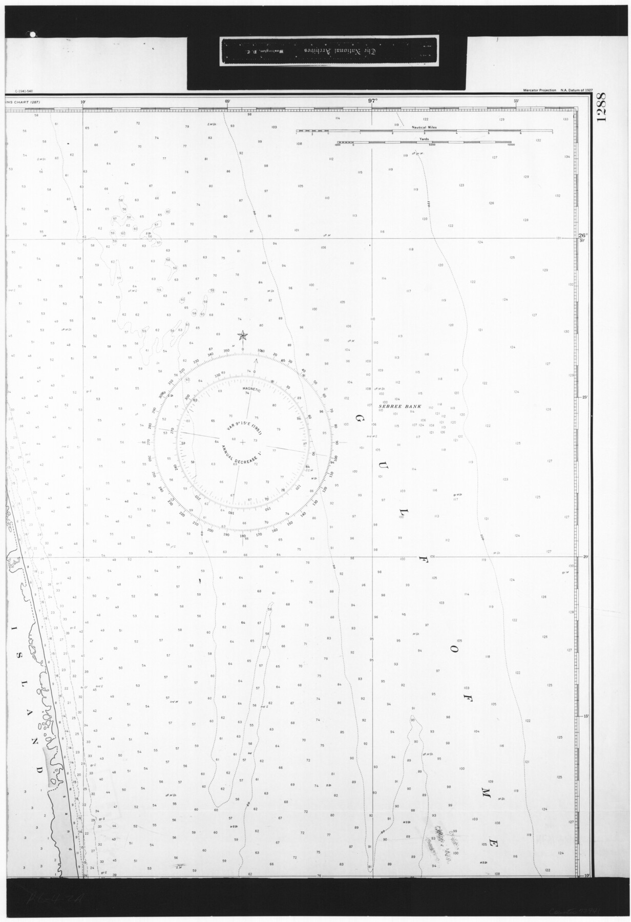
United States - Gulf Coast Texas - Southern part of Laguna Madre
RL-4-2a
-
Map/Doc
72941
-
Collection
General Map Collection
-
Object Dates
1941 (Creation Date)
-
People and Organizations
U. S. Coast and Geodetic Survey (Publisher)
U. S. Coast and Geodetic Survey (Author)
-
Subjects
Nautical Charts
-
Height x Width
26.6 x 18.2 inches
67.6 x 46.2 cm
-
Comments
B/W photostat copy from National Archives in multiple pieces.
Part of: General Map Collection
Glasscock County Sketch File 1

Print $46.00
- Digital $50.00
Glasscock County Sketch File 1
Size 26.1 x 31.8 inches
Map/Doc 11558
Liberty County Working Sketch 79

Print $40.00
- Digital $50.00
Liberty County Working Sketch 79
1981
Size 63.7 x 41.4 inches
Map/Doc 70539
Schleicher County Working Sketch 17

Print $20.00
- Digital $50.00
Schleicher County Working Sketch 17
1946
Size 21.8 x 23.1 inches
Map/Doc 63819
Nueces County Rolled Sketch 129

Print $20.00
- Digital $50.00
Nueces County Rolled Sketch 129
1998
Size 18.1 x 24.5 inches
Map/Doc 7164
Navarro County Working Sketch 15

Print $20.00
- Digital $50.00
Navarro County Working Sketch 15
1993
Size 16.1 x 17.8 inches
Map/Doc 71245

Flight Mission No. DCL-7C, Frame 106, Kenedy County

Print $20.00
- Digital $50.00
Flight Mission No. DCL-7C, Frame 106, Kenedy County
1943
Size 18.5 x 22.3 inches
Map/Doc 86071
Flight Mission No. CRK-8P, Frame 101, Refugio County

Print $20.00
- Digital $50.00
Flight Mission No. CRK-8P, Frame 101, Refugio County
1956
Size 18.7 x 22.3 inches
Map/Doc 86962
Orange County Sketch File 1

Print $6.00
- Digital $50.00
Orange County Sketch File 1
Size 9.6 x 11.5 inches
Map/Doc 33299
Hunt County Sketch File 36

Print $6.00
- Digital $50.00
Hunt County Sketch File 36
1879
Size 8.0 x 6.9 inches
Map/Doc 27150
Padre Island National Seashore

Print $4.00
- Digital $50.00
Padre Island National Seashore
Size 16.0 x 22.0 inches
Map/Doc 60529
Foard County Boundary File 3

Print $48.00
- Digital $50.00
Foard County Boundary File 3
Size 24.2 x 6.0 inches
Map/Doc 53516
You may also like
Brewster County Sketch File 49

Print $26.00
- Digital $50.00
Brewster County Sketch File 49
1994
Size 14.2 x 8.8 inches
Map/Doc 16329
[Surveys near the Sabine River]
![302, [Surveys near the Sabine River], General Map Collection](https://historictexasmaps.com/wmedia_w700/maps/302.tif.jpg)
Print $20.00
- Digital $50.00
[Surveys near the Sabine River]
1840
Size 18.8 x 20.9 inches
Map/Doc 302
Liberty County Sketch File 7

Print $4.00
- Digital $50.00
Liberty County Sketch File 7
Size 13.4 x 6.2 inches
Map/Doc 29897
San Saba County Boundary File 77

Print $32.00
- Digital $50.00
San Saba County Boundary File 77
Size 9.2 x 7.7 inches
Map/Doc 58577
El Paso County Sketch File 40

Print $20.00
- Digital $50.00
El Paso County Sketch File 40
1988
Size 24.8 x 35.9 inches
Map/Doc 11461
Palo Pinto County

Print $20.00
- Digital $50.00
Palo Pinto County
1856
Size 29.9 x 20.9 inches
Map/Doc 1394
Brazoria County Working Sketch 43

Print $20.00
- Digital $50.00
Brazoria County Working Sketch 43
1985
Size 37.3 x 32.7 inches
Map/Doc 67528
Limestone County Sketch File 18

Print $6.00
- Digital $50.00
Limestone County Sketch File 18
Size 16.0 x 10.7 inches
Map/Doc 30191
General Highway Map, Bexar County, Texas

Print $20.00
General Highway Map, Bexar County, Texas
1940
Size 18.4 x 25.1 inches
Map/Doc 76287
A New Map of Texas

Print $20.00
- Digital $50.00
A New Map of Texas
1841
Size 17.6 x 16.2 inches
Map/Doc 93862
Reagan County Rolled Sketch 31

Print $20.00
- Digital $50.00
Reagan County Rolled Sketch 31
1955
Size 26.5 x 28.8 inches
Map/Doc 7447
Austin County

Print $20.00
- Digital $50.00
Austin County
1943
Size 38.5 x 41.3 inches
Map/Doc 77205