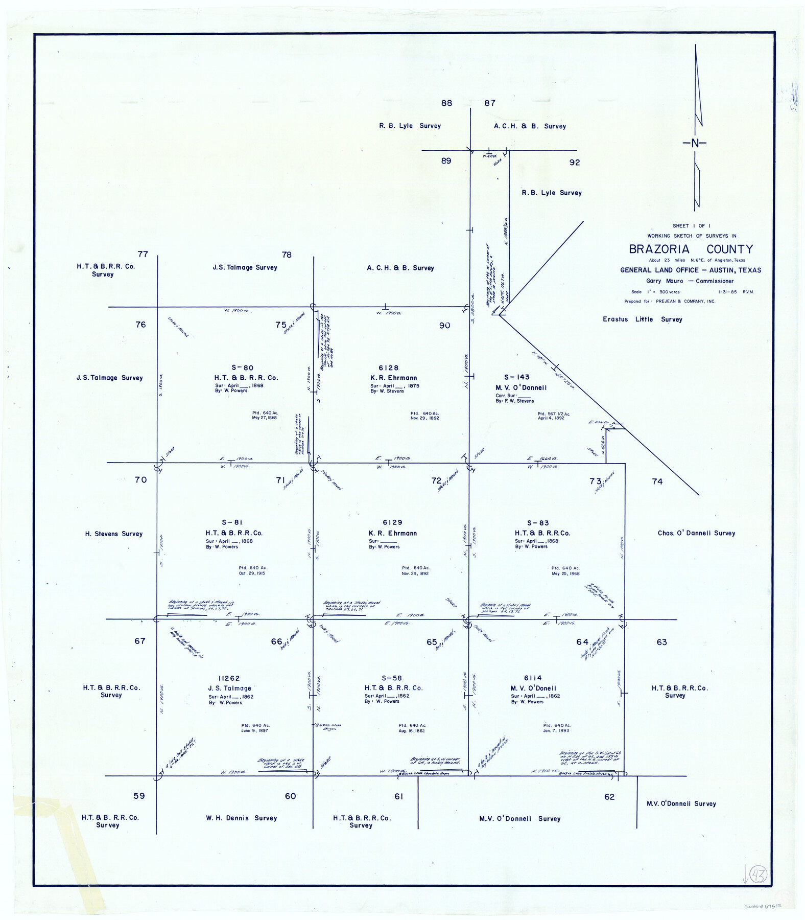
Brazoria County Working Sketch 43
-
Map/Doc
67528
-
Collection
General Map Collection
-
Object Dates
1/31/1985 (Creation Date)
-
People and Organizations
Garry Mauro (GLO Commissioner)
Rosendo V. Molina (Draftsman)
-
Counties
Brazoria
-
Subjects
Surveying Working Sketch
-
Height x Width
37.3 x 32.7 inches
94.7 x 83.1 cm
-
Scale
1" = 300 varas
-
Comments
Surveys located about 23 miles North six degrees East of Angleton, Texas.
Part of: General Map Collection
Starr County Sketch File 47

Print $6.00
- Digital $50.00
Starr County Sketch File 47
1949
Size 11.2 x 8.8 inches
Map/Doc 37002
The University of Texas at Austin

The University of Texas at Austin
Size 16.1 x 17.1 inches
Map/Doc 94387
Flight Mission No. CGI-3N, Frame 43, Cameron County

Print $20.00
- Digital $50.00
Flight Mission No. CGI-3N, Frame 43, Cameron County
1954
Size 18.5 x 22.1 inches
Map/Doc 84549
Old Miscellaneous File 24

Print $6.00
- Digital $50.00
Old Miscellaneous File 24
1919
Size 14.4 x 8.7 inches
Map/Doc 75629
Moore County Sketch File 5

Print $22.00
- Digital $50.00
Moore County Sketch File 5
Size 9.0 x 12.6 inches
Map/Doc 31937
Map of the country between the frontiers of Arkansas and New Mexico embracing the section explored in 1849, 50, 51, & 52

Print $40.00
- Digital $50.00
Map of the country between the frontiers of Arkansas and New Mexico embracing the section explored in 1849, 50, 51, & 52
Size 29.9 x 62.3 inches
Map/Doc 95837

Right of Way and Track Map, International & Gt. Northern Ry. Operated by the International & Gt. Northern Ry. Co., Gulf Division

Print $40.00
- Digital $50.00
Right of Way and Track Map, International & Gt. Northern Ry. Operated by the International & Gt. Northern Ry. Co., Gulf Division
1917
Size 24.8 x 56.5 inches
Map/Doc 64251
Presidio County Rolled Sketch 83B

Print $20.00
- Digital $50.00
Presidio County Rolled Sketch 83B
Size 16.6 x 23.0 inches
Map/Doc 2061
Edwards County Working Sketch 39

Print $20.00
- Digital $50.00
Edwards County Working Sketch 39
1948
Size 28.7 x 32.3 inches
Map/Doc 68915
Concho, San Saba & Llano Valley Railway, Sterling City Branch, Texas. Right of Way and Track Map

Print $40.00
- Digital $50.00
Concho, San Saba & Llano Valley Railway, Sterling City Branch, Texas. Right of Way and Track Map
1910
Size 18.3 x 59.7 inches
Map/Doc 64439
Aransas County Rolled Sketch 24

Print $20.00
- Digital $50.00
Aransas County Rolled Sketch 24
Size 22.5 x 34.8 inches
Map/Doc 77495
You may also like
Houston County Sketch File 35

Print $8.00
- Digital $50.00
Houston County Sketch File 35
1840
Size 11.2 x 9.0 inches
Map/Doc 26813
Tech Town a Subdivision of the Northeast Quarter Section 18, Block B

Print $20.00
- Digital $50.00
Tech Town a Subdivision of the Northeast Quarter Section 18, Block B
Size 17.5 x 21.6 inches
Map/Doc 92792
Runnels County Working Sketch 3

Print $20.00
- Digital $50.00
Runnels County Working Sketch 3
1888
Size 22.1 x 20.3 inches
Map/Doc 63599
Live Oak County Rolled Sketch 9

Print $20.00
- Digital $50.00
Live Oak County Rolled Sketch 9
1982
Size 25.6 x 23.3 inches
Map/Doc 6636
Lipscomb County Boundary File 12

Print $4.00
- Digital $50.00
Lipscomb County Boundary File 12
Size 10.6 x 8.1 inches
Map/Doc 56351
Hidalgo County Working Sketch 8

Print $40.00
- Digital $50.00
Hidalgo County Working Sketch 8
1963
Size 25.7 x 72.8 inches
Map/Doc 66185
Johnson County Working Sketch 34

Print $20.00
- Digital $50.00
Johnson County Working Sketch 34
2008
Size 20.0 x 21.2 inches
Map/Doc 88890
[Galveston, Harrisburg & San Antonio through El Paso County]
![64012, [Galveston, Harrisburg & San Antonio through El Paso County], General Map Collection](https://historictexasmaps.com/wmedia_w700/maps/64012.tif.jpg)
Print $20.00
- Digital $50.00
[Galveston, Harrisburg & San Antonio through El Paso County]
1906
Size 13.6 x 33.8 inches
Map/Doc 64012
Map of Swisher County

Print $40.00
- Digital $50.00
Map of Swisher County
1900
Size 48.5 x 41.1 inches
Map/Doc 16890
Galveston County Rolled Sketch 22

Print $20.00
- Digital $50.00
Galveston County Rolled Sketch 22
1953
Size 28.8 x 39.5 inches
Map/Doc 9663
Blanco County Sketch File 37

Print $4.00
- Digital $50.00
Blanco County Sketch File 37
Size 8.7 x 14.1 inches
Map/Doc 14646
[R. M. Thompson Block T2 and John H. Stephens Block S2 Conflict]
![91056, [R. M. Thompson Block T2 and John H. Stephens Block S2 Conflict], Twichell Survey Records](https://historictexasmaps.com/wmedia_w700/maps/91056-1.tif.jpg)
Print $20.00
- Digital $50.00
[R. M. Thompson Block T2 and John H. Stephens Block S2 Conflict]
Size 20.9 x 30.6 inches
Map/Doc 91056